IMAGES TAKEN NEAR TO
Ridley Road, BURY ST. EDMUNDS, IP33 3HS
Introduction
This page details the photographs taken nearby to Ridley Road, IP33 3HS by members of the Geograph project.
The Geograph project started in 2005 with the aim of publishing, organising and preserving representative images for every square kilometre of Great Britain, Ireland and the Isle of Man.

There are currently over 7.5m images from over14,400 individuals and you can help contribute to the project by visiting https://www.geograph.org.uk
Image Map
Images are licensed for reuse under creativecommons.org/licenses/by-sa/2.0
Notes
- Clicking on the map will re-center to the selected point.
- The higher the marker number, the further away the image location is from the centre of the postcode.
Image Listing (17 Images Found)
Images are licensed for reuse under creativecommons.org/licenses/by-sa/2.0
Image
Details
Distance
1
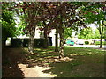
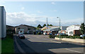
A corner of the Westley estate
Named after the nearest village and the airfield that occupied this site, the Westley estate was built starting in the 1950s.
The footpath on the left goes to Westley, and was repositioned off the airfield in the 1930s.
Image: © John Goldsmith
Taken: 15 May 2010
0.13 miles
2
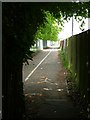
Footpath to Westley
The Bury St. Edmunds end of a footpath to Westley village. This first section is tarmac surfaced and marked into a footpath by the stick man, and a bicycle lane, the symbol for which is hidden on the left. The purpose of the cycle lane is not clear as this path eventually turns into a rough footpath on which cycling is presumably not allowed. The fence on the left keeps intruders out of the middle school, while on the right there is another footpath at the back of the Westley estate houses. Why two side by side paths?
Image: © John Goldsmith
Taken: 15 May 2010
0.13 miles
3
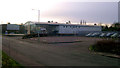
Closed car dealer, Dettingen Way, Bury St. Edmunds
The former Ford Dealership.
Image: © John Goldsmith
Taken: 19 Dec 2008
0.14 miles
4
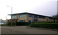
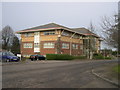
Office building, Dettingen Way, Bury St. Edmunds
Image: © John Goldsmith
Taken: 19 Dec 2008
0.14 miles
5
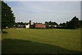
Westley Middle School
The rear of the school, across the playing field.
Image: © Bob Jones
Taken: 22 Jun 2005
0.15 miles
6
Insurance company office, Dettingen Way, Bury St. Edmunds
The traffic lights at the junction to Newmarket Road are just visible on the right.
The building has a very odd roof.
Image: © John Goldsmith
Taken: 19 Dec 2008
0.16 miles
7
Unused site, Dettingen Way, Bury St. Edmunds
A three-photo pan. Apologies to the company whose building has been turned into a banana!
Image: © John Goldsmith
Taken: 19 Dec 2008
0.18 miles
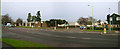
8
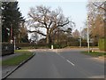
The junction where Flemyng Road meets Westley Road
Image: © Robert Edwards
Taken: 2 Mar 2011
0.23 miles
9
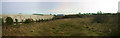
Western Way West
This little stub off the main part of Western Way houses a dairy at the end of the road, the former Miro Press printers and a company that puts the glossy lamination on cardboard products (remember LP sleeves?)
Image: © John Goldsmith
Taken: 3 Sep 2008
0.23 miles
10
Junction of Western Way and Newmarket Road.
The Minden Rose public house is on the right. The premises on the left have a recent new occupant, having been owned for many years by the industrial vacuum cleaner maker Nilfisk.
At one time Newmarket Road was on the main East-West route of East Anglia, now replaced by the A14. The junction recently gained the enormous yellow hatched box which would virtually stop traffic flow if anyone took any notice of it.
Image: © John Goldsmith
Taken: 19 Dec 2008
0.24 miles