
IMAGES TAKEN NEAR TO
School Yard, BURY ST. EDMUNDS, IP33 3FS
Introduction
This page details the photographs taken nearby to School Yard, IP33 3FS by members of the Geograph project.
The Geograph project started in 2005 with the aim of publishing, organising and preserving representative images for every square kilometre of Great Britain, Ireland and the Isle of Man.

There are currently over 7.5m images from over14,400 individuals and you can help contribute to the project by visiting https://www.geograph.org.uk
Image Map
Images are licensed for reuse under creativecommons.org/licenses/by-sa/2.0
Notes
- Clicking on the map will re-center to the selected point.
- The higher the marker number, the further away the image location is from the centre of the postcode.
Image Listing (677 Images Found)
Images are licensed for reuse under creativecommons.org/licenses/by-sa/2.0
Image
Details
Distance
1
![Bury St Edmunds houses [303]](https://s3.geograph.org.uk/geophotos/06/69/82/6698235_c780bcf4_120x120.jpg)
Bury St Edmunds houses [303]
Recently built (2014) apartments in Prospect Row. Prospect Row was created in 1852 as an entrance to the cattle market. A plaque on the gable wall of number 17 Risbygate Street Image reads 'This entrance to the CATTLE MARKET Made by Order of the Town Council August 1852. J.P.EVERARD Esq, Mayor'.
Image: © Michael Dibb
Taken: 7 Sep 2020
0.01 miles
2
![Bury St Edmunds buildings [235]](https://s2.geograph.org.uk/geophotos/06/69/82/6698234_e2d1b5e8_120x120.jpg)
Bury St Edmunds buildings [235]
Originally one house, once divided into two and lately recombined, numbers 16 and 17 Risbygate Street are now offices with a flat above. Built in the early 18th century, incorporating fragments of an earlier core, timber framed and stuccoed with the framing exposed on the gable wall. The attic storey and the rear range are later 18th century alterations and additions. Listed, grade II, with details at: https://historicengland.org.uk/listing/the-list/list-entry/1244900
Brentgovel Street and Risbygate Street was a prosperous area in the fifteenth century but it became neglected and decay had set in. In the 1990s, a Conservation Area Partnership Schemes was introduced to give a new lease of life into the area by repairing and reusing historic buildings. Forty five new residential units and ten new retail units have resulted in the area thriving again.
Bury St Edmunds is a market town which is the cultural and retail centre for West Suffolk and is known for brewing (Greene King) and sugar (British Sugar). There is scattered evidence of earlier activity but essentially Bury St Edmunds began as one of the royal boroughs of the Saxons and a monastery was founded which became the burial place of King Edmund. A new Benedictine abbey was built in 1020 which became rich and powerful and the town was laid out on a grid pattern by Abbot Baldwin. After the dissolution the abbey became ruinous. A new church, later the cathedral, was begun in the early 16th century.
Image: © Michael Dibb
Taken: 7 Sep 2020
0.01 miles
3
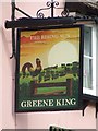
The Rising Sun pub sign
The Rising Sun pub sign Risbygate street Bury St.Edmunds Suffolk
Image: © Keith Evans
Taken: 9 Mar 2008
0.02 miles
4
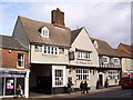
St Edmunds Tavern on Risbygate Street
St Edmunds Tavern, formerly called the Rising Sun.
Image: © Martin Speck
Taken: 10 Oct 2011
0.02 miles
5
![Bury St Edmunds buildings [242]](https://s3.geograph.org.uk/geophotos/06/69/90/6699043_2d1b5aa9_120x120.jpg)
Bury St Edmunds buildings [242]
Now a winebar and restaurant, number 98 Risbygate Street was formerly The Rising Sun public house, also briefly known as St Edmunds Tavern. Built as a house in the 15th and 16th centuries with extensions in the 17th century and later alterations. The plan is complex with a central gabled and jettied cross wing between two jettied ranges. Timber framed and mostly stuccoed with some exposed timbers. Listed, grade II*, with details at: https://historicengland.org.uk/listing/the-list/list-entry/1244921
Brentgovel Street and Risbygate Street was a prosperous area in the fifteenth century but it became neglected and decay had set in. In the 1990s, a Conservation Area Partnership Schemes was introduced to give a new lease of life into the area by repairing and reusing historic buildings. Forty-five new residential units and ten new retail units have resulted in the area thriving again.
Bury St Edmunds is a market town which is the cultural and retail centre for West Suffolk and is known for brewing (Greene King) and sugar (British Sugar). There is scattered evidence of earlier activity but essentially Bury St Edmunds began as one of the royal boroughs of the Saxons and a monastery was founded which became the burial place of King Edmund. A new Benedictine abbey was built in 1020 which became rich and powerful and the town was laid out on a grid pattern by Abbot Baldwin. After the dissolution the abbey became ruinous. A new church, later the cathedral, was begun in the early 16th century.
Image: © Michael Dibb
Taken: 7 Sep 2020
0.02 miles
6
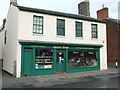
Anglia arms
Anglia arms gun and country accessories shop Risbygate Street Bury St.Edmunds Suffolk.
Image: © Keith Evans
Taken: 9 Mar 2008
0.02 miles
7
![Bury St Edmunds buildings [240]](https://s1.geograph.org.uk/geophotos/06/69/83/6698329_6b07c84f_120x120.jpg)
Bury St Edmunds buildings [240]
This building, numbers 93,94 and 95 Risbygate Street was built as two separate houses which were merged to become one house. Later divided into three and subsequently re-divided into two, now used as offices. The two bays on the left are 16th century and partly replaced a mid 14th century house set at right angles to the street. The rest of the building is 16th century, timber framed, jettied to the street and refronted in the early 19th century. Listed, grade II*, with details at: https://historicengland.org.uk/listing/the-list/list-entry/1244918
Brentgovel Street and Risbygate Street was a prosperous area in the fifteenth century but it became neglected and decay had set in. In the 1990s, a Conservation Area Partnership Schemes was introduced to give a new lease of life into the area by repairing and reusing historic buildings. Forty five new residential units and ten new retail units have resulted in the area thriving again.
Bury St Edmunds is a market town which is the cultural and retail centre for West Suffolk and is known for brewing (Greene King) and sugar (British Sugar). There is scattered evidence of earlier activity but essentially Bury St Edmunds began as one of the royal boroughs of the Saxons and a monastery was founded which became the burial place of King Edmund. A new Benedictine abbey was built in 1020 which became rich and powerful and the town was laid out on a grid pattern by Abbot Baldwin. After the dissolution the abbey became ruinous. A new church, later the cathedral, was begun in the early 16th century.
Image: © Michael Dibb
Taken: 8 Sep 2020
0.02 miles
8
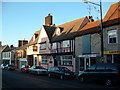
The Rising Sun
The Rising Sun public house Risbygate street Bury St.edmunds Suffolk. See link of the same location taken in 1987. http://www.geograph.org.uk/photo/294833
Image: © Keith Evans
Taken: 17 Dec 2006
0.02 miles
9
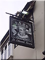
St Edmunds Tavern sign
St Edmunds Tavern sign on Risbygate Street.
Image: © Martin Speck
Taken: 10 Oct 2011
0.02 miles
10
![Bury St Edmunds buildings [243]](https://s2.geograph.org.uk/geophotos/06/69/90/6699046_1f41b61d_120x120.jpg)
Bury St Edmunds buildings [243]
Numbers 98A, 99 and 100 Risbygate Street were originally a house and two cottages.
Built in the early 19th century with a 17th century core, timber framed with brick fronts. By the mid 1990s, the premises had been given consent for demolition and office redevelopment. Purchased by the Town Trust who constructed three self-contained shops with three flats above on the street elevation and four new dwellings to the rear. Listed, grade II, with details at: https://historicengland.org.uk/listing/the-list/list-entry/1244993
Brentgovel Street and Risbygate Street was a prosperous area in the fifteenth century but it became neglected and decay had set in. In the 1990s, a Conservation Area Partnership Schemes was introduced to give a new lease of life into the area by repairing and reusing historic buildings. Forty five new residential units and ten new retail units have resulted in the area thriving again.
Bury St Edmunds is a market town which is the cultural and retail centre for West Suffolk and is known for brewing (Greene King) and sugar (British Sugar). There is scattered evidence of earlier activity but essentially Bury St Edmunds began as one of the royal boroughs of the Saxons and a monastery was founded which became the burial place of King Edmund. A new Benedictine abbey was built in 1020 which became rich and powerful and the town was laid out on a grid pattern by Abbot Baldwin. After the dissolution the abbey became ruinous. A new church, later the cathedral, was begun in the early 16th century.
Image: © Michael Dibb
Taken: 7 Sep 2020
0.02 miles