Bury St Edmunds buildings [240]
Introduction
The photograph on this page of Bury St Edmunds buildings [240] by Michael Dibb as part of the Geograph project.
The Geograph project started in 2005 with the aim of publishing, organising and preserving representative images for every square kilometre of Great Britain, Ireland and the Isle of Man.

There are currently over 7.5m images from over 14,400 individuals and you can help contribute to the project by visiting https://www.geograph.org.uk
Bury St Edmunds buildings [240]
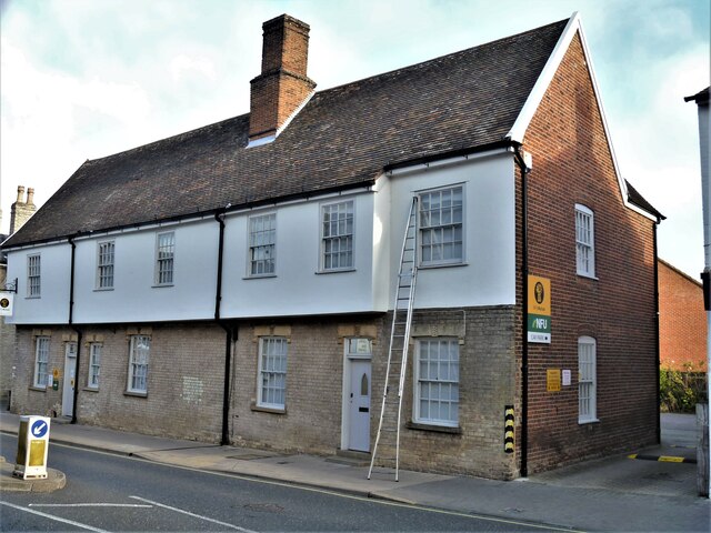
Image: © Michael Dibb Taken: 8 Sep 2020
This building, numbers 93,94 and 95 Risbygate Street was built as two separate houses which were merged to become one house. Later divided into three and subsequently re-divided into two, now used as offices. The two bays on the left are 16th century and partly replaced a mid 14th century house set at right angles to the street. The rest of the building is 16th century, timber framed, jettied to the street and refronted in the early 19th century. Listed, grade II*, with details at: https://historicengland.org.uk/listing/the-list/list-entry/1244918 Brentgovel Street and Risbygate Street was a prosperous area in the fifteenth century but it became neglected and decay had set in. In the 1990s, a Conservation Area Partnership Schemes was introduced to give a new lease of life into the area by repairing and reusing historic buildings. Forty five new residential units and ten new retail units have resulted in the area thriving again. Bury St Edmunds is a market town which is the cultural and retail centre for West Suffolk and is known for brewing (Greene King) and sugar (British Sugar). There is scattered evidence of earlier activity but essentially Bury St Edmunds began as one of the royal boroughs of the Saxons and a monastery was founded which became the burial place of King Edmund. A new Benedictine abbey was built in 1020 which became rich and powerful and the town was laid out on a grid pattern by Abbot Baldwin. After the dissolution the abbey became ruinous. A new church, later the cathedral, was begun in the early 16th century.
Images are licensed for reuse under creativecommons.org/licenses/by-sa/2.0
Image Location
Latitude
52.247393
Longitude
0.708669