
IMAGES TAKEN NEAR TO
Kings Road, BURY ST. EDMUNDS, IP33 3DP
Introduction
This page details the photographs taken nearby to Kings Road, IP33 3DP by members of the Geograph project.
The Geograph project started in 2005 with the aim of publishing, organising and preserving representative images for every square kilometre of Great Britain, Ireland and the Isle of Man.

There are currently over 7.5m images from over14,400 individuals and you can help contribute to the project by visiting https://www.geograph.org.uk
Image Map
Images are licensed for reuse under creativecommons.org/licenses/by-sa/2.0
Notes
- Clicking on the map will re-center to the selected point.
- The higher the marker number, the further away the image location is from the centre of the postcode.
Image Listing (270 Images Found)
Images are licensed for reuse under creativecommons.org/licenses/by-sa/2.0
Image
Details
Distance
1
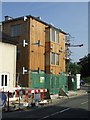
New development
New local housing authority housing under construction on the corner of Kings Road and the Parkway Bury St.Edmunds, Suffolk. For another view see http://www.geograph.org.uk/photo/989106
Image: © Keith Evans
Taken: 20 Sep 2008
0.01 miles
2
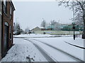
Parkway and Kings Road roundabout in the snow
Parkway and Kings Road roundabout in the snow Bury St.Edmunds Suffolk.
Image: © Keith Evans
Taken: 23 Mar 2008
0.01 miles
3
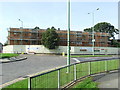
New development
New local housing authority housing under construction on the corner of Kings Road and the Parkway Bury St.Edmunds, Suffolk. For another view see http://www.geograph.org.uk/photo/989101
Image: © Keith Evans
Taken: 20 Sep 2008
0.02 miles
4
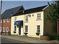
Mane Attraction
Former pub now a hairdressers called Mane Attraction Kings Road Bury St. Edmunds, Suffolk. The pub was called The Wheatsheaf it began its life as a beerhouse in the late 1850's and closed its doors in 1981.
Image: © Keith Evans
Taken: 20 Sep 2008
0.02 miles
5
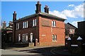
Former Yeomanry Barracks - Kings Road
Built as the barracks for the Suffolk Yeomanry in 1857. Remained in use by the Territorial Army until 1977. Large yard to rear of entrance with drill hall redeveloped as housing in 1991. In 1914 Yeomanry HQ.
Image: © Bob Jones
Taken: 3 Mar 2015
0.02 miles
6
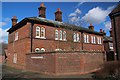
Rear of Barracks Entrance - Kings Road
Built as the barracks for the Suffolk Yeomanry in 1857. Remained in use by the Territorial Army until 1977. Large yard to rear of entrance with drill hall redeveloped as housing in 1991. In 1914 Yeomanry HQ.
Image: © Bob Jones
Taken: 3 Mar 2015
0.02 miles
7
![Bury St Edmunds houses [336]](https://s3.geograph.org.uk/geophotos/06/70/40/6704075_32efd0cc_120x120.jpg)
Bury St Edmunds houses [336]
Numbers 30 to 33 King's Road are four flats occupying one of the buildings that were part of the former barracks of the West Suffolk Militia Regiment. This is the surviving building of a pair which included the armoury, guard room and orderly room. Built in 1858 in dark red brick with blue brick headers and lighter red brick dressings. See also Image Listed, along with numbers 28 and 29 Image, grade II, with details at: https://historicengland.org.uk/listing/the-list/list-entry/1022571
Much of the centre of the town has suffered from redevelopment and most buildings are later than the mid 19th century. There are some uninspiring modern buildings along Parkway and the Arc shopping centre is particularly ugly, especially the building occupied by Debenhams.
Bury St Edmunds is a market town which is the cultural and retail centre for West Suffolk and is known for brewing (Greene King) and sugar (British Sugar). There is scattered evidence of earlier activity but essentially Bury St Edmunds began as one of the royal boroughs of the Saxons and a monastery was founded which became the burial place of King Edmund. A new Benedictine abbey was built in 1020 which became rich and powerful and the town was laid out on a grid pattern by Abbot Baldwin. After the dissolution the abbey became ruinous. A new church, later the cathedral, was begun in the early 16th century.
Image: © Michael Dibb
Taken: 9 Sep 2020
0.02 miles
8

King's Road, Bury St Edmunds
Looking away from the town centre from the junction with Parkway.
Image: © Richard Vince
Taken: 3 Feb 2018
0.02 miles
9
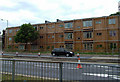
Sponsored by Cuprinol ?
Some very odd architecture in this new building on Parkway.
Who really wants to live next to a dual carriageway, a roundabout, and several food outlets?
Image: © John Goldsmith
Taken: 6 Jun 2009
0.02 miles
10
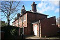
Rear of Barracks Entrance/Guardhouse - Kings Road
Built as the barracks for the Suffolk Yeomanry in 1857. Remained in use by the Territorial Army until 1977. Large yard to rear of entrance with drill hall redeveloped as housing in 1991. In 1914 Yeomanry HQ.
Image: © Bob Jones
Taken: 3 Mar 2015
0.02 miles