Bury St Edmunds houses [336]
Introduction
The photograph on this page of Bury St Edmunds houses [336] by Michael Dibb as part of the Geograph project.
The Geograph project started in 2005 with the aim of publishing, organising and preserving representative images for every square kilometre of Great Britain, Ireland and the Isle of Man.

There are currently over 7.5m images from over 14,400 individuals and you can help contribute to the project by visiting https://www.geograph.org.uk
Bury St Edmunds houses [336]
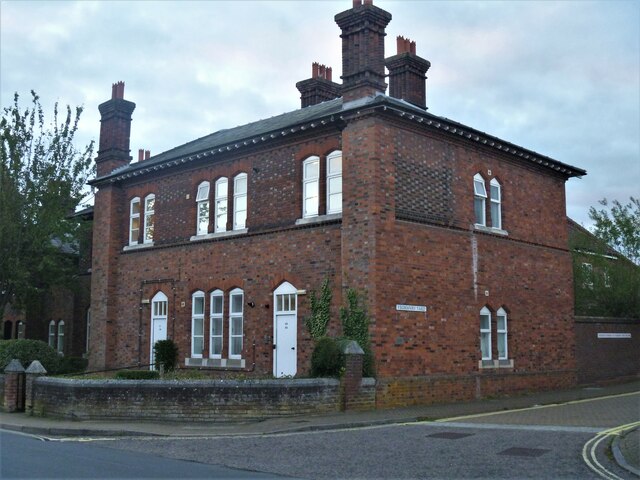
Image: © Michael Dibb Taken: 9 Sep 2020
Numbers 30 to 33 King's Road are four flats occupying one of the buildings that were part of the former barracks of the West Suffolk Militia Regiment. This is the surviving building of a pair which included the armoury, guard room and orderly room. Built in 1858 in dark red brick with blue brick headers and lighter red brick dressings. See also Image Listed, along with numbers 28 and 29 Image, grade II, with details at: https://historicengland.org.uk/listing/the-list/list-entry/1022571 Much of the centre of the town has suffered from redevelopment and most buildings are later than the mid 19th century. There are some uninspiring modern buildings along Parkway and the Arc shopping centre is particularly ugly, especially the building occupied by Debenhams. Bury St Edmunds is a market town which is the cultural and retail centre for West Suffolk and is known for brewing (Greene King) and sugar (British Sugar). There is scattered evidence of earlier activity but essentially Bury St Edmunds began as one of the royal boroughs of the Saxons and a monastery was founded which became the burial place of King Edmund. A new Benedictine abbey was built in 1020 which became rich and powerful and the town was laid out on a grid pattern by Abbot Baldwin. After the dissolution the abbey became ruinous. A new church, later the cathedral, was begun in the early 16th century.
Images are licensed for reuse under creativecommons.org/licenses/by-sa/2.0
Image Location
Latitude
52.244387
Longitude
0.706435