IMAGES TAKEN NEAR TO
Grove Park, BURY ST. EDMUNDS, IP33 3BG
Introduction
This page details the photographs taken nearby to Grove Park, IP33 3BG by members of the Geograph project.
The Geograph project started in 2005 with the aim of publishing, organising and preserving representative images for every square kilometre of Great Britain, Ireland and the Isle of Man.

There are currently over 7.5m images from over14,400 individuals and you can help contribute to the project by visiting https://www.geograph.org.uk
Image Map
Images are licensed for reuse under creativecommons.org/licenses/by-sa/2.0
Notes
- Clicking on the map will re-center to the selected point.
- The higher the marker number, the further away the image location is from the centre of the postcode.
Image Listing (117 Images Found)
Images are licensed for reuse under creativecommons.org/licenses/by-sa/2.0
Image
Details
Distance
1
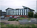
New building, West Suffolk College
Further major development plans have just been put on hold due to a funding crisis.
Image: © John Goldsmith
Taken: 6 Sep 2008
0.05 miles
2
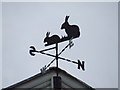
Bunny weather vane
Bunny weather vane above the entrance of St.Edmunds primary school Grove road Bury St.Edmunds Suffolk.
Image: © Keith Evans
Taken: 2 Dec 2007
0.05 miles
3
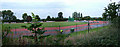
Running Track, Bury Leisure Centre
It's a landscape shot of Bury St. Edmunds, so it goes without saying that the sugar factory silos are visible on the horizon! That's why the CBers call us Sugartown. Viewing point was the Leisure Centre entrance.
Image: © John Goldsmith
Taken: 11 Sep 2008
0.07 miles
4
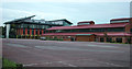
Buildings at West Suffolk College
The car park in the foreground was originally the practice marching square of the barracks.
Image: © John Goldsmith
Taken: 6 Sep 2008
0.09 miles
5
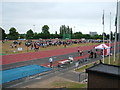
School sports on athletics track
I've never seen an athletics event before with the viewing crowd in the middle of the track. I don't know which school it was, and that is probably just as well, as many of the athletes in the relay race I witnessed did not seem very serious about it. Another odd feature was that the tent on the right housed a live cover-version rock band, which, judging by an overheard conversation with the mayor as he left, was made up of school pupils.
The sugar factory silos are visible in the distance.
Image: © John Goldsmith
Taken: 13 Jul 2010
0.10 miles
6
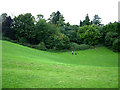
'The Bomb Hole' Risbygate Street
Generally known as The Bomb Hole, or The Dip, but more officially titled St. Peter's Pit, this feature is probably a disused chalk working or a collapse where chalk has dissolved in rainwater. As the only public space in Bury St. Edmunds with a steep hill it is a favourite spot with children when it snows.
The official name comes from the medieval leprosy hospital that was in this area and has also given its name to St. Peter's House and St. Peter's Villas.
Image: © John Goldsmith
Taken: 8 Sep 2008
0.10 miles
7
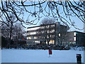
Sunset reflects off West Suffolk College
The windows of the main building of West Suffolk College reflect a sunset sky, in a snowy scene. The college site is split in two by the tall wall visible to the left, a legacy of the barracks formerly on part of the site.
Image: © John Goldsmith
Taken: 8 Jan 2010
0.10 miles
8
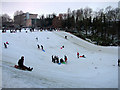
Sledging at St. Peter's Pit
This is the favourite sledging spot for Bury St. Edmunds - one of the few steep slopes with public access. St. Peter's pit is basically rectangular, but a fenced off private site occupies one side, and another side is lightly wooded. Despite the use of two routes at right angles there are few collisions. The fence acts as a final stop, and depending on footwear can provide a necessary help on the return climb.
As well as plastic, wooden and metal runner sledges, improvised versions included carpet squares, plastic bags (including one girl wearing one like a short skirt), a tarpaulin with 7 riders, a blow-up jetski, crates fixed to real skis, skateboards with wheels removed, surf boards, and the rather unsuccessful bread tray visible here (It's the wrong way round you idiot).
What a brilliant way for children to get serious exercise and to very clearly enjoy it. And a great way to socialise.
Houses in Grove Park and the West Suffolk College can be seen behind.
Image: © John Goldsmith
Taken: 8 Jan 2010
0.11 miles
9
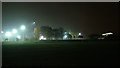
Sports arena by night
The main illumination in the photo is the Sports Centre's running track and other outdoor facilities. On the right is West Suffolk House, the offices of Suffolk County Council and St. Edmundsbury Council. The field in the foreground belongs to King Edward VI School.
The sports arena was built on an area previously used by the Victorian barracks.
Image: © John Goldsmith
Taken: 22 Nov 2011
0.11 miles
10
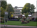
West Suffolk College from across the street
It was recently announced that the college would like to demolish these 1960s buildings and rebuild, as they are so old that they are no longer fit for purpose. What does that say about the many establishments operating from Victorian buildings, and even more so the colleges in Cambridge and Oxford?
The building has now vanished behind a wall of scaffolding and netting.
The College certainly does its part to support Bury in Bloom.
The large stone near the planter is the so-called plague stone. This appears to be a part of a looted pillar from the abbey and was reputedly used as a wash basin for travellers' coins during the Black Death.
This view is the reverse of Image
Image: © John Goldsmith
Taken: 21 Jun 2011
0.11 miles