IMAGES TAKEN NEAR TO
Springfield Road, BURY ST. EDMUNDS, IP33 3AR
Introduction
This page details the photographs taken nearby to Springfield Road, IP33 3AR by members of the Geograph project.
The Geograph project started in 2005 with the aim of publishing, organising and preserving representative images for every square kilometre of Great Britain, Ireland and the Isle of Man.

There are currently over 7.5m images from over14,400 individuals and you can help contribute to the project by visiting https://www.geograph.org.uk
Image Map
Images are licensed for reuse under creativecommons.org/licenses/by-sa/2.0
Notes
- Clicking on the map will re-center to the selected point.
- The higher the marker number, the further away the image location is from the centre of the postcode.
Image Listing (170 Images Found)
Images are licensed for reuse under creativecommons.org/licenses/by-sa/2.0
Image
Details
Distance
1
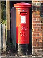
G R Postbox
G R Postbox Springfield Road Bury St.Edmunds Suffolk.
Image: © Keith Evans
Taken: 30 Dec 2008
0.03 miles
2
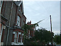
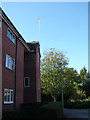
Telephone line creeper
On the western side of Springfield Road. The neighbouring houses are Nelson Villa and Trafalgar Villa, which may be a clue to their age. But the terraces further down the road are dated 1896 to 1900.
Image: © John Goldsmith
Taken: 8 Sep 2008
0.07 miles
3
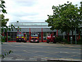
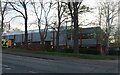
Fire station cleaning, Parkway, Bury St. Edmunds
The appliances have been moved outside while the building has a thorough cleaning, using the 'cherry picker' vehicle on the right.
Image: © John Goldsmith
Taken: 3 Jun 2009
0.08 miles
4
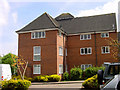
Block 1, Trinity Mews
Built 1987. 9 flats in this block, but there are 5 other blocks.
Image: © John Goldsmith
Taken: 11 Aug 2007
0.08 miles
5
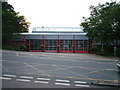
Fire Station, Bury St. Edmunds
Off Parkway. While this road provides good road access in most directions, the position at the bottom of a long hill seems odd, when sites could have been found at the top.
This is at least the third Fire Station in Bury St. Edmunds - a town centre building still carries the carved stone marking. A later one in Fornham Road was demolished for housing.
Note the decorative flower baskets - Bury is a repeat winner in the Britain In Bloom contest.
Image: © John Goldsmith
Taken: 6 Sep 2008
0.08 miles
6

Fire station viewed through Trinity Mews arch
Image: © John Goldsmith
Taken: 19 Oct 2008
0.09 miles
7
Sign of the times, new aerial for digital TV
Last week the digital TV switch-over started in this area, with BBC2 switched off. The aerial used to be mounted in the roof and receive just 4 analogue channels from a repeater transmitter on the sugar factory. We were advised that we needed new equipment for digital transmissions, and it would be better to add a tall mast and get the signals from the main transmitter at Tacolneston, providing all the Freeview channels right away. Here the shiny new aerial glints in the sun.
Image: © John Goldsmith
Taken: 30 Sep 2011
0.09 miles
8
![Bury St Edmunds buildings [270]](https://s3.geograph.org.uk/geophotos/06/70/47/6704751_14328e46_120x120.jpg)
Bury St Edmunds buildings [270]
This modern building in Parkway is a fire and ambulance station opened in 1987.
Much of the centre of the town has suffered from redevelopment and most buildings are later than the mid 19th century. There are some uninspiring modern buildings along Parkway and the Arc shopping centre is particularly ugly, especially the building occupied by Debenhams.
Bury St Edmunds is a market town which is the cultural and retail centre for West Suffolk and is known for brewing (Greene King) and sugar (British Sugar). There is scattered evidence of earlier activity but essentially Bury St Edmunds began as one of the royal boroughs of the Saxons and a monastery was founded which became the burial place of King Edmund. A new Benedictine abbey was built in 1020 which became rich and powerful and the town was laid out on a grid pattern by Abbot Baldwin. After the dissolution the abbey became ruinous. A new church, later the cathedral, was begun in the early 16th century.
Image: © Michael Dibb
Taken: 7 Sep 2020
0.09 miles
10
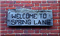
Welcome to Spring Lane
This sign is actually flanked by a couple of hooks for hanging baskets, but sadly none are fitted. The sign was erected in the 1980s when an area of allotments was converted to be a temporary wildlife area pending the construction of housing. The area attracted lots of 'green' people, hippies and tree huggers, then when the houses were finally planned they said 'You can't destroy our wild area'. So far they have their way. It provides an interesting contrast to an adjacent slightly more managed park area, and then the Tayfen Meadows estate.
Image: © John Goldsmith
Taken: 8 Jun 2009
0.09 miles