
IMAGES TAKEN NEAR TO
Linnet Place, BURY ST. EDMUNDS, IP33 2ND
Introduction
This page details the photographs taken nearby to Linnet Place, IP33 2ND by members of the Geograph project.
The Geograph project started in 2005 with the aim of publishing, organising and preserving representative images for every square kilometre of Great Britain, Ireland and the Isle of Man.

There are currently over 7.5m images from over14,400 individuals and you can help contribute to the project by visiting https://www.geograph.org.uk
Image Map
Images are licensed for reuse under creativecommons.org/licenses/by-sa/2.0
Notes
- Clicking on the map will re-center to the selected point.
- The higher the marker number, the further away the image location is from the centre of the postcode.
Image Listing (158 Images Found)
Images are licensed for reuse under creativecommons.org/licenses/by-sa/2.0
Image
Details
Distance
1
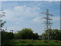
View from No Man's Meadow towards the town
Featuring the electrical supply to Bury St. Edmunds, with the old and new substation connections also shown in Image and Image Just to the left of the pylon the top of a stone tower can be seen - I think this is the Norman Tower.
Image: © John Goldsmith
Taken: 2 Sep 2011
0.04 miles
2
![Bury St Edmunds houses [195]](https://s1.geograph.org.uk/geophotos/06/68/21/6682181_345d1f86_120x120.jpg)
Bury St Edmunds houses [195]
Number 24 Southgate Street is mid 16th century, timber framed and stuccoed, jettied along the street. There is a two storey gabled rear wing in an L shaped plan. There is a 19th century addition in the angle between the front range and the rear wing. Listed, grade II, with details at: https://historicengland.org.uk/listing/the-list/list-entry/1272109
Sparhawk Street runs from Honey Hill via the open space of St Mary’s Square to Southgate Street which leads to Southgate Green, the site of the town’s Southgate and where St Petronella’s Hospital was located, established in the 12th century for the treatment of female lepers. The area is rich in history and has a great variety of buildings.
Bury St Edmunds is a market town which is the cultural and retail centre for West Suffolk and is known for brewing (Greene King) and sugar (British Sugar). There is scattered evidence of earlier activity but essentially Bury St Edmunds began as one of the royal boroughs of the Saxons and a monastery was founded which became the burial place of King Edmund. A new Benedictine abbey was built in 1020 which became rich and powerful and the town was laid out on a grid pattern by Abbot Baldwin. After the dissolution the abbey became ruinous. A new church, later the cathedral, was begun in the early 16th century.
Image: © Michael Dibb
Taken: 9 Sep 2020
0.04 miles
3
![Bury St Edmunds houses [196]](https://s2.geograph.org.uk/geophotos/06/68/21/6682182_3136aa61_120x120.jpg)
Bury St Edmunds houses [196]
Linnet House, number 32 Southgate Street, has a 17th century front range and an 18th century long rear range in a L shaped plan. Timber framed and stuccoed. There is a plaque below the central window to Henry Crabb Robinson (1775-1867). There are various later additions. Listed, grade II, with details at: https://historicengland.org.uk/listing/the-list/list-entry/1272112
Sparhawk Street runs from Honey Hill via the open space of St Mary’s Square to Southgate Street which leads to Southgate Green, the site of the town’s Southgate and where St Petronella’s Hospital was located, established in the 12th century for the treatment of female lepers. The area is rich in history and has a great variety of buildings.
Bury St Edmunds is a market town which is the cultural and retail centre for West Suffolk and is known for brewing (Greene King) and sugar (British Sugar). There is scattered evidence of earlier activity but essentially Bury St Edmunds began as one of the royal boroughs of the Saxons and a monastery was founded which became the burial place of King Edmund. A new Benedictine abbey was built in 1020 which became rich and powerful and the town was laid out on a grid pattern by Abbot Baldwin. After the dissolution the abbey became ruinous. A new church, later the cathedral, was begun in the early 16th century.
Image: © Michael Dibb
Taken: 9 Sep 2020
0.04 miles
4

The Oast House, Bury St. Edmunds
Oast houses are normally associated mainly with Kent, and I had lived in Bury St. Edmunds for decades before I discovered that we have one in the town. It has obviously been converted to housing and/or offices.
In the foreground we see a storage yard for a builders' merchants.
Image: © John Goldsmith
Taken: 2 Sep 2011
0.04 miles
5
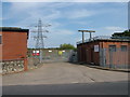
Disused part of substation
This part seems to be disused since a recent refurbishment, and the newer part can be seen in Image
The road is Raingate Street and the field behind is No Man's Meadows, a flood plain beside the river Lark. So it is a good job Suffolk suffers very little from flooding, or we would soon lose our power.
Image: © John Goldsmith
Taken: 2 Sep 2011
0.05 miles
6
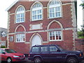
Old Mission House
The stone tablet over the door says 'Old Mission House' which seems a little strange, as no-one names something as Old - it only becomes known as Old after a new one is built. The building displays lots of interesting brickwork - the sections over the lower windows are not even the same. The different coloured bricks under these windows suggest that the sills may have been raised.
Image: © John Goldsmith
Taken: 2 Sep 2011
0.05 miles
7
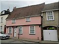
24 Southgate Street, Bury St Edmunds
Sixteenth century house https://historicengland.org.uk/listing/the-list/list-entry/1272109?section=official-list-entry
Image: © Jonathan Thacker
Taken: 16 May 2022
0.05 miles
8
![Bury St Edmunds houses [208]](https://s1.geograph.org.uk/geophotos/06/68/34/6683433_e20c9c37_120x120.jpg)
Bury St Edmunds houses [208]
Numbers 130 and 131 Southgate Street were originally one house irregularly divided into two. The 5 bays to the north (furthest from the camera) are 18th century, the 2 bays to the south are 19th century with a lower roof pitch. Built in dark red brick with lighter red brick dressings. There are two rear extensions of the 1960s. Listed, grade II, with details at: https://historicengland.org.uk/listing/the-list/list-entry/1272159
Sparhawk Street runs from Honey Hill via the open space of St Mary’s Square to Southgate Street which leads to Southgate Green, the site of the town’s Southgate and where St Petronella’s Hospital was located, established in the 12th century for the treatment of female lepers. The area is rich in history and has a great variety of buildings.
Bury St Edmunds is a market town which is the cultural and retail centre for West Suffolk and is known for brewing (Greene King) and sugar (British Sugar). There is scattered evidence of earlier activity but essentially Bury St Edmunds began as one of the royal boroughs of the Saxons and a monastery was founded which became the burial place of King Edmund. A new Benedictine abbey was built in 1020 which became rich and powerful and the town was laid out on a grid pattern by Abbot Baldwin. After the dissolution the abbey became ruinous. A new church, later the cathedral, was begun in the early 16th century.
Image: © Michael Dibb
Taken: 9 Sep 2020
0.05 miles
9
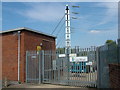
New power feed into substation
This main feed to Bury St. Edmunds has had a recent refurbishment - the old parts remain to the south of the site.
Image: © John Goldsmith
Taken: 2 Sep 2011
0.05 miles
10
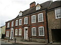
130/131 Southgate Street, Bury St Edmunds
Eighteenth century house with nineteenth century extension https://historicengland.org.uk/listing/the-list/list-entry/1272159?section=official-list-entry
Image: © Jonathan Thacker
Taken: 16 May 2022
0.05 miles