IMAGES TAKEN NEAR TO
Glastonbury Road, BURY ST. EDMUNDS, IP33 2EX
Introduction
This page details the photographs taken nearby to Glastonbury Road, IP33 2EX by members of the Geograph project.
The Geograph project started in 2005 with the aim of publishing, organising and preserving representative images for every square kilometre of Great Britain, Ireland and the Isle of Man.

There are currently over 7.5m images from over14,400 individuals and you can help contribute to the project by visiting https://www.geograph.org.uk
Image Map
Images are licensed for reuse under creativecommons.org/licenses/by-sa/2.0
Notes
- Clicking on the map will re-center to the selected point.
- The higher the marker number, the further away the image location is from the centre of the postcode.
Image Listing (7 Images Found)
Images are licensed for reuse under creativecommons.org/licenses/by-sa/2.0
Image
Details
Distance
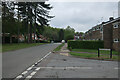
1

The Glad Abbot
The Glad Abbot pub Glastonbury Rd, Bury St.Edmunds, Suffolk.
Image: © Claire Evans
Taken: 11 Mar 2009
0.03 miles
3
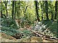
Former chalk pit, Bury St Edmunds
There are several pits and mine tunnels. The area is now woodland and the area is a biological Site of Special Scientific Interest due to the tunnels which are used by bats for hibernation [Horringer Court Caves]
Image: © Richard Rogerson
Taken: 30 Apr 2022
0.19 miles
5
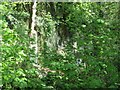
Horringer Court Caves
Horringer Court Caves is a 3.8 hectare biological Site of Special Scientific Interest on the southern outskirts of Bury St Edmunds in Suffolk.
This site has over 500 metres of chalk mines, with five grilled entrances, one of which is shown in the photo. they are used by bats for hibernation. They have been the subject of research since 1947. The main bats using the caves are Daubenton's, but other species include the very rare barbastelle, which have been recorded eight times in 36 years.
Image: © Richard Rogerson
Taken: 30 Apr 2022
0.23 miles
7
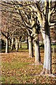
Tree-lined walk by the River Linnet
The narrow stream just visible through the trees is the River Linnet, which joins the larger River Lark in the centre of Bury St Edmunds. Here, at the junction of Huntingfield Road and Winthrop Road, there is a pleasant walk alongside the river.
Image: © Bob Jones
Taken: 12 Nov 2007
0.25 miles