IMAGES TAKEN NEAR TO
IP33 1YU
Introduction
This page details the photographs taken nearby to IP33 1YU by members of the Geograph project.
The Geograph project started in 2005 with the aim of publishing, organising and preserving representative images for every square kilometre of Great Britain, Ireland and the Isle of Man.

There are currently over 7.5m images from over14,400 individuals and you can help contribute to the project by visiting https://www.geograph.org.uk
Image Map
Images are licensed for reuse under creativecommons.org/licenses/by-sa/2.0
Notes
- Clicking on the map will re-center to the selected point.
- The higher the marker number, the further away the image location is from the centre of the postcode.
Image Listing (471 Images Found)
Images are licensed for reuse under creativecommons.org/licenses/by-sa/2.0
Image
Details
Distance
1
![Bury St Edmunds buildings [223]](https://s0.geograph.org.uk/geophotos/06/69/66/6696612_816f483d_120x120.jpg)
Bury St Edmunds buildings [223]
The former St James Infant School at number 139 Eastgate Street, was built in 1872 on land donated by the Marquis of Bristol. Constructed in knapped flint with stone and ashlar dressings, the property is now holiday accommodation. Listed, grade II, with details at: https://historicengland.org.uk/listing/the-list/list-entry/1363683
Until the second half of the 20th century, there were almost no buildings east of the River Lark except along Eastgate Street which has a number of 16th and 17th century houses. Now there are several large housing estates and a fairly large industrial estate.
Bury St Edmunds is a market town which is the cultural and retail centre for West Suffolk and is known for brewing (Greene King) and sugar (British Sugar). There is scattered evidence of earlier activity but essentially Bury St Edmunds began as one of the royal boroughs of the Saxons and a monastery was founded which became the burial place of King Edmund. A new Benedictine abbey was built in 1020 which became rich and powerful and the town was laid out on a grid pattern by Abbot Baldwin. After the dissolution the abbey became ruinous. A new church, later the cathedral, was begun in the early 16th century.
Image: © Michael Dibb
Taken: 8 Sep 2020
0.03 miles
2
![Bury St Edmunds features [37]](https://s0.geograph.org.uk/geophotos/06/69/48/6694872_f005fbb5_120x120.jpg)
Bury St Edmunds features [37]
A glimpse of the bridge that carries Eastgate Street over the River Lark. Erected in 1840, the railings on both approaches once surrounded the market cross. Listed, grade II, with details at: https://historicengland.org.uk/listing/the-list/list-entry/1343604
Until the second half of the 20th century, there were almost no buildings east of the River Lark except along Eastgate Street which has a number of 16th and 17th century houses. Now there are several large housing estates and a fairly large industrial estate.
Bury St Edmunds is a market town which is the cultural and retail centre for West Suffolk and is known for brewing (Greene King) and sugar (British Sugar). There is scattered evidence of earlier activity but essentially Bury St Edmunds began as one of the royal boroughs of the Saxons and a monastery was founded which became the burial place of King Edmund. A new Benedictine abbey was built in 1020 which became rich and powerful and the town was laid out on a grid pattern by Abbot Baldwin. After the dissolution the abbey became ruinous. A new church, later the cathedral, was begun in the early 16th century.
Image: © Michael Dibb
Taken: 8 Sep 2020
0.05 miles
3
![Bury St Edmunds houses [299]](https://s2.geograph.org.uk/geophotos/06/69/66/6696610_becb0377_120x120.jpg)
Bury St Edmunds houses [299]
This row of 6 cottages, number 1 to 6, The Vinefields, in flint and red brick is completely unaltered from 1834 when it was built. The Vinefields leads off Eastgate Street towards what once was the abbey vineyards. Listed, grade II, with details at: https://historicengland.org.uk/listing/the-list/list-entry/1038278
Until the second half of the 20th century, there were almost no buildings east of the River Lark except along Eastgate Street which has a number of 16th and 17th century houses. Now there are several large housing estates and a fairly large industrial estate.
Bury St Edmunds is a market town which is the cultural and retail centre for West Suffolk and is known for brewing (Greene King) and sugar (British Sugar). There is scattered evidence of earlier activity but essentially Bury St Edmunds began as one of the royal boroughs of the Saxons and a monastery was founded which became the burial place of King Edmund. A new Benedictine abbey was built in 1020 which became rich and powerful and the town was laid out on a grid pattern by Abbot Baldwin. After the dissolution the abbey became ruinous. A new church, later the cathedral, was begun in the early 16th century.
Image: © Michael Dibb
Taken: 8 Sep 2020
0.05 miles
4
![Bury St Edmunds houses [283]](https://s2.geograph.org.uk/geophotos/06/69/57/6695742_ace7161f_120x120.jpg)
Bury St Edmunds houses [283]
Number 12 Eastgate Street is 16th century, timber framed and roughcast, with 18th century additions and a 19th century front. The refronting included a shop front which remains but with a window replacing the door. Listed, grade II, with details at: https://historicengland.org.uk/listing/the-list/list-entry/1075230
Until the second half of the 20th century, there were almost no buildings east of the River Lark except along Eastgate Street which has a number of 16th and 17th century houses. Now there are several large housing estates and a fairly large industrial estate.
Bury St Edmunds is a market town which is the cultural and retail centre for West Suffolk and is known for brewing (Greene King) and sugar (British Sugar). There is scattered evidence of earlier activity but essentially Bury St Edmunds began as one of the royal boroughs of the Saxons and a monastery was founded which became the burial place of King Edmund. A new Benedictine abbey was built in 1020 which became rich and powerful and the town was laid out on a grid pattern by Abbot Baldwin. After the dissolution the abbey became ruinous. A new church, later the cathedral, was begun in the early 16th century.
Image: © Michael Dibb
Taken: 8 Sep 2020
0.05 miles
5
![Bury St Edmunds houses [284]](https://s3.geograph.org.uk/geophotos/06/69/57/6695743_ae597158_120x120.jpg)
Bury St Edmunds houses [284]
Numbers 13 and 14 Eastgate Street were originally one house, now divided into two. Built in the early to mid 17th century with 19th century rear extensions. Timber framed with roughcast (number 13) and stucco (number 14). Number 13 has aground floor shop window. Listed, grade II, with details at: https://historicengland.org.uk/listing/the-list/list-entry/1075231
Until the second half of the 20th century, there were almost no buildings east of the River Lark except along Eastgate Street which has a number of 16th and 17th century houses. Now there are several large housing estates and a fairly large industrial estate.
Bury St Edmunds is a market town which is the cultural and retail centre for West Suffolk and is known for brewing (Greene King) and sugar (British Sugar). There is scattered evidence of earlier activity but essentially Bury St Edmunds began as one of the royal boroughs of the Saxons and a monastery was founded which became the burial place of King Edmund. A new Benedictine abbey was built in 1020 which became rich and powerful and the town was laid out on a grid pattern by Abbot Baldwin. After the dissolution the abbey became ruinous. A new church, later the cathedral, was begun in the early 16th century.
Image: © Michael Dibb
Taken: 8 Sep 2020
0.05 miles
6
![Bury St Edmunds houses [285]](https://s0.geograph.org.uk/geophotos/06/69/57/6695748_960cd8ad_120x120.jpg)
Bury St Edmunds houses [285]
Seemingly a terrace of old houses, numbers 18 to 22 Eastgate Street is three separate houses, two of which have been divided into two. This view shows the end truss of the now-demolished house which stood to the west of Number 18. The houses are described in detail at Image, Image and Image
Until the second half of the 20th century, there were almost no buildings east of the River Lark except along Eastgate Street which has a number of 16th and 17th century houses. Now there are several large housing estates and a fairly large industrial estate.
Bury St Edmunds is a market town which is the cultural and retail centre for West Suffolk and is known for brewing (Greene King) and sugar (British Sugar). There is scattered evidence of earlier activity but essentially Bury St Edmunds began as one of the royal boroughs of the Saxons and a monastery was founded which became the burial place of King Edmund. A new Benedictine abbey was built in 1020 which became rich and powerful and the town was laid out on a grid pattern by Abbot Baldwin. After the dissolution the abbey became ruinous. A new church, later the cathedral, was begun in the early 16th century.
Image: © Michael Dibb
Taken: 8 Sep 2020
0.06 miles
7
![Bury St Edmunds houses [286]](https://s1.geograph.org.uk/geophotos/06/69/57/6695749_32521002_120x120.jpg)
Bury St Edmunds houses [286]
Number 18 Eastgate Street was built in the late 16th or early 17th century, timber framed and stuccoed, jettied to the street. There is a later rear extension built in two phases. Listed, grade II, with details at: https://historicengland.org.uk/listing/the-list/list-entry/1075233
Until the second half of the 20th century, there were almost no buildings east of the River Lark except along Eastgate Street which has a number of 16th and 17th century houses. Now there are several large housing estates and a fairly large industrial estate.
Bury St Edmunds is a market town which is the cultural and retail centre for West Suffolk and is known for brewing (Greene King) and sugar (British Sugar). There is scattered evidence of earlier activity but essentially Bury St Edmunds began as one of the royal boroughs of the Saxons and a monastery was founded which became the burial place of King Edmund. A new Benedictine abbey was built in 1020 which became rich and powerful and the town was laid out on a grid pattern by Abbot Baldwin. After the dissolution the abbey became ruinous. A new church, later the cathedral, was begun in the early 16th century.
Image: © Michael Dibb
Taken: 8 Sep 2020
0.06 miles
8
![Bury St Edmunds buildings [221]](https://s1.geograph.org.uk/geophotos/06/69/57/6695745_3beac5e5_120x120.jpg)
Bury St Edmunds buildings [221]
Number 15 Eastgate Street was originally a house, now a shop with storage over. Built in the early 17th century, timber framed and stuccoed. There is a later rear wing, built in two phases, the first phase timber framed. The double shop front is late 20th century. Listed, grade II, with details at: https://historicengland.org.uk/listing/the-list/list-entry/1075232
Until the second half of the 20th century, there were almost no buildings east of the River Lark except along Eastgate Street which has a number of 16th and 17th century houses. Now there are several large housing estates and a fairly large industrial estate.
Bury St Edmunds is a market town which is the cultural and retail centre for West Suffolk and is known for brewing (Greene King) and sugar (British Sugar). There is scattered evidence of earlier activity but essentially Bury St Edmunds began as one of the royal boroughs of the Saxons and a monastery was founded which became the burial place of King Edmund. A new Benedictine abbey was built in 1020 which became rich and powerful and the town was laid out on a grid pattern by Abbot Baldwin. After the dissolution the abbey became ruinous. A new church, later the cathedral, was begun in the early 16th century.
Image: © Michael Dibb
Taken: 8 Sep 2020
0.06 miles
9
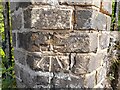
OS Benchmark
Recorded on Benchmark Database as 'Bury St Edmunds, Bridge Over River Lark'.
Image: © David Bremner
Taken: 9 May 2023
0.06 miles
10
![Bury St Edmunds houses [288]](https://s3.geograph.org.uk/geophotos/06/69/57/6695751_0e855481_120x120.jpg)
Bury St Edmunds houses [288]
Numbers 21 and 22 Eastgate Street were originally one house, now divided into two. Built in the early to mid 16th century, timber framed and jettied to the street. The first floor is stuccoed, the ground floor is in white brick. Listed, grade II, with details at: https://historicengland.org.uk/listing/the-list/list-entry/1343592
Until the second half of the 20th century, there were almost no buildings east of the River Lark except along Eastgate Street which has a number of 16th and 17th century houses. Now there are several large housing estates and a fairly large industrial estate.
Bury St Edmunds is a market town which is the cultural and retail centre for West Suffolk and is known for brewing (Greene King) and sugar (British Sugar). There is scattered evidence of earlier activity but essentially Bury St Edmunds began as one of the royal boroughs of the Saxons and a monastery was founded which became the burial place of King Edmund. A new Benedictine abbey was built in 1020 which became rich and powerful and the town was laid out on a grid pattern by Abbot Baldwin. After the dissolution the abbey became ruinous. A new church, later the cathedral, was begun in the early 16th century.
Image: © Michael Dibb
Taken: 8 Sep 2020
0.06 miles