
IMAGES TAKEN NEAR TO
Mustow Street, BURY ST. EDMUNDS, IP33 1XU
Introduction
This page details the photographs taken nearby to Mustow Street, IP33 1XU by members of the Geograph project.
The Geograph project started in 2005 with the aim of publishing, organising and preserving representative images for every square kilometre of Great Britain, Ireland and the Isle of Man.

There are currently over 7.5m images from over14,400 individuals and you can help contribute to the project by visiting https://www.geograph.org.uk
Image Map
Images are licensed for reuse under creativecommons.org/licenses/by-sa/2.0
Notes
- Clicking on the map will re-center to the selected point.
- The higher the marker number, the further away the image location is from the centre of the postcode.
Image Listing (1160 Images Found)
Images are licensed for reuse under creativecommons.org/licenses/by-sa/2.0
Image
Details
Distance
1
![Bury St Edmunds houses [277]](https://s1.geograph.org.uk/geophotos/06/69/47/6694753_6dfbc6c2_120x120.jpg)
Bury St Edmunds houses [277]
This house at number 17 Mustow Street was built in 1926 entirely from timbers from a row of demolished timber framed buildings. Timber framed, jettied on two sides with an elaborate corner post. Listed because the house conserves the timbers, grade II, with details at: https://historicengland.org.uk/listing/the-list/list-entry/1022600
Until the second half of the 20th century, there were almost no buildings east of the River Lark except along Eastgate Street which has a number of 16th and 17th century houses. Now there are several large housing estates and a fairly large industrial estate.
Bury St Edmunds is a market town which is the cultural and retail centre for West Suffolk and is known for brewing (Greene King) and sugar (British Sugar). There is scattered evidence of earlier activity but essentially Bury St Edmunds began as one of the royal boroughs of the Saxons and a monastery was founded which became the burial place of King Edmund. A new Benedictine abbey was built in 1020 which became rich and powerful and the town was laid out on a grid pattern by Abbot Baldwin. After the dissolution the abbey became ruinous. A new church, later the cathedral, was begun in the early 16th century.
Image: © Michael Dibb
Taken: 8 Sep 2020
0.01 miles
2
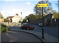
Remains of Abbey Gardens wall
Mustow Street.
Image: © Mr Ignavy
Taken: 27 Oct 2008
0.01 miles
3
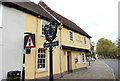
The Fox Inn, Eastgate, Bury St, Edmunds
https://www.geograph.org.uk/photo/6653120
Image: © Adrian S Pye
Taken: 26 Oct 2020
0.02 miles
4
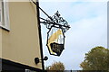
Sign of The Fox Inn
https://www.geograph.org.uk/photo/6653115
Image: © Adrian S Pye
Taken: 26 Oct 2020
0.02 miles
5
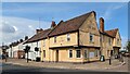
The Fox Inn, Bury St Edmunds
https://historicengland.org.uk/listing/the-list/list-entry/1075223?section=official-list-entry
Image: © Sandy Gerrard
Taken: 16 Apr 2023
0.02 miles
6
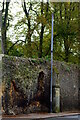
Stinkpipe Edmund in Mustow Street
This tall iron sewer vent pipe rises high over the medieval wall of the abbey precinct, just within the former east gate of the town. The Image identifies the manufacturer as Wm E. Farrer of Birmingham.
Image: © Tiger
Taken: 23 Oct 2021
0.02 miles
7
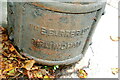
Base of the stinkpipe
William E. Farrer (1868-1931) was born in Oldham and set up as a sanitary engineer in Hall Green, Birmingham. This tall Image stands against the ancient wall of the abbey precinct and not far from the former east gate of the town and the River Lark.
Image: © Tiger
Taken: 23 Oct 2021
0.02 miles
8
![Bury St Edmunds Abbey precincts [3]](https://s0.geograph.org.uk/geophotos/06/64/03/6640332_c4bf511b_120x120.jpg)
Bury St Edmunds Abbey precincts [3]
Much of the abbey precincts are enclosed by 12th century walls. Here the wall at the side of Mustow Street is some 88 yards (80 metres) long from the site of the former East Gate to the present entrance to the gardens. Listed, grade I with details at: https://historicengland.org.uk/listing/the-list/list-entry/1375548
The Abbey Gardens occupy the site of St Edmund's Abbey. In 1953 the Borough bought the Gardens and managed the area around the abbey ruins, thus reuniting the two main parts of the Abbey Precinct - the Abbey Gardens and the Great Churchyard. The gardens are on the Register of Historic Parks and Gardens, grade II, and there is much history and detail at: https://historicengland.org.uk/listing/the-list/list-entry/1001493 Except for the Great Churchyard the site is a Scheduled Ancient Monument and there is much history and detail at: https://historicengland.org.uk/listing/the-list/list-entry/1021450
Image: © Michael Dibb
Taken: 8 Sep 2020
0.02 miles
9
![Bury St Edmunds buildings [220]](https://s2.geograph.org.uk/geophotos/06/69/47/6694758_bf5af6d9_120x120.jpg)
Bury St Edmunds buildings [220]
This delightful 15th century former merchant's house is now The Fox Inn at number 1 Eastgate Street. On a corner site, timber-framed and stuccoed in an half-H form with two jettied cross-wings. In the 19th century there was a rear extension and the roof of the central part was raised. Listed, grade II*, with details at: https://historicengland.org.uk/listing/the-list/list-entry/1075223
Until the second half of the 20th century, there were almost no buildings east of the River Lark except along Eastgate Street which has a number of 16th and 17th century houses. Now there are several large housing estates and a fairly large industrial estate.
Bury St Edmunds is a market town which is the cultural and retail centre for West Suffolk and is known for brewing (Greene King) and sugar (British Sugar). There is scattered evidence of earlier activity but essentially Bury St Edmunds began as one of the royal boroughs of the Saxons and a monastery was founded which became the burial place of King Edmund. A new Benedictine abbey was built in 1020 which became rich and powerful and the town was laid out on a grid pattern by Abbot Baldwin. After the dissolution the abbey became ruinous. A new church, later the cathedral, was begun in the early 16th century.
Image: © Michael Dibb
Taken: 8 Sep 2020
0.02 miles
10
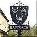
Bury St Edmunds, Eastgate sign
The sign shows three crowns, each pierced by two arrows saltire, the crest of the great abbey which grew up around Saint Edmund’s shrine. King Edmund of East Anglia, otherwise known as Edmund the Martyr was King from 855 until he was killed at an unidentified place known as Haegelisdun, after he refused the Danes' demand that he renounce Christ: the Danes beat him, shot him with arrows and then beheaded him just to be on the safe side. His body was taken to what is now Bury St Edmunds and a shrine was created. I don’t think anyone knows what Bury St Edmunds was called before it was re-named Bury St. Edmunds; Haegelisdun perhaps. https://www.geograph.org.uk/photo/6655804
Image: © Adrian S Pye
Taken: 26 Oct 2020
0.02 miles