IMAGES TAKEN NEAR TO
Churchgate Street, BURY ST. EDMUNDS, IP33 1RG
Introduction
This page details the photographs taken nearby to Churchgate Street, IP33 1RG by members of the Geograph project.
The Geograph project started in 2005 with the aim of publishing, organising and preserving representative images for every square kilometre of Great Britain, Ireland and the Isle of Man.

There are currently over 7.5m images from over14,400 individuals and you can help contribute to the project by visiting https://www.geograph.org.uk
Image Map
Images are licensed for reuse under creativecommons.org/licenses/by-sa/2.0
Notes
- Clicking on the map will re-center to the selected point.
- The higher the marker number, the further away the image location is from the centre of the postcode.
Image Listing (2017 Images Found)
Images are licensed for reuse under creativecommons.org/licenses/by-sa/2.0
Image
Details
Distance
1
![Bury St Edmunds buildings [63]](https://s1.geograph.org.uk/geophotos/06/65/67/6656797_c6592d23_120x120.jpg)
Bury St Edmunds buildings [63]
Originally a house, number 31 Churchgate Street is now a shop with a flat above. Built in the 16th century, timber framed and jettied, the building was refronted, underbuilding the jetty, and raised to three storeys in the early 19th century, with roughcast render. There is a 17th century rear extension and other extensions of various dates. Listed, grade II, with details at: https://historicengland.org.uk/listing/the-list/list-entry/1248123
Churchgate Street is aligned with the Norman Tower entrance to the Abbey and would have been the ceremonial route between the Abbey and the Guildhall, the spiritual and the temporal. The street has some of the town’s most important historic buildings with structures dating back to the 13th century.
Bury St Edmunds is a market town which is the cultural and retail centre for West Suffolk and is known for brewing (Greene King) and sugar (British Sugar). There is scattered evidence of earlier activity but essentially Bury St Edmunds began as one of the royal boroughs of the Saxons and a monastery was founded which became the burial place of King Edmund. A new Benedictine abbey was built in 1020 which became rich and powerful and the town was laid out on a grid pattern by Abbot Baldwin. After the dissolution the abbey became ruinous. A new church, later the cathedral, was begun in the early 16th century.
Image: © Michael Dibb
Taken: 12 Sep 2020
0.01 miles
2
![Bury St Edmunds buildings [61]](https://s1.geograph.org.uk/geophotos/06/65/60/6656057_03dd37a6_120x120.jpg)
Bury St Edmunds buildings [61]
Number 28 Churchgate Street, now a shop with living accommodation above, was originally two houses built in the 16th or 17th century. The white brick front was added in 1835 to the timber framed and stuccoed building. There is a rear 17th century extension. Part of one of the original houses survives in number 29 adjoining (Image). Listed, grade II, with details at: https://historicengland.org.uk/listing/the-list/list-entry/1248120
Churchgate Street is aligned with the Norman Tower entrance to the Abbey and would have been the ceremonial route between the Abbey and the Guildhall, the spiritual and the temporal. The street has some of the town’s most important historic buildings with structures dating back to the 13th century.
Bury St Edmunds is a market town which is the cultural and retail centre for West Suffolk and is known for brewing (Greene King) and sugar (British Sugar). There is scattered evidence of earlier activity but essentially Bury St Edmunds began as one of the royal boroughs of the Saxons and a monastery was founded which became the burial place of King Edmund. A new Benedictine abbey was built in 1020 which became rich and powerful and the town was laid out on a grid pattern by Abbot Baldwin. After the dissolution the abbey became ruinous. A new church, later the cathedral, was begun in the early 16th century.
Image: © Michael Dibb
Taken: 12 Sep 2020
0.01 miles
3
![Bury St Edmunds buildings [62]](https://s0.geograph.org.uk/geophotos/06/65/60/6656072_cab62531_120x120.jpg)
Bury St Edmunds buildings [62]
Originally a house, number 29 Churchgate Street is now a shop with a flat above. Built in the mid 16th century the timber framed and jettied building was raised and fronted in white brick in the early 19th century. The shop front is early 19th century. Within the shop a main beam on the side wall originally formed the centre beam of a 2-bay room which extended into what is now the adjoining property, number 28 Image Listed, grade II, with details at: https://historicengland.org.uk/listing/the-list/list-entry/1248121
Churchgate Street is aligned with the Norman Tower entrance to the Abbey and would have been the ceremonial route between the Abbey and the Guildhall, the spiritual and the temporal. The street has some of the town’s most important historic buildings with structures dating back to the 13th century.
Bury St Edmunds is a market town which is the cultural and retail centre for West Suffolk and is known for brewing (Greene King) and sugar (British Sugar). There is scattered evidence of earlier activity but essentially Bury St Edmunds began as one of the royal boroughs of the Saxons and a monastery was founded which became the burial place of King Edmund. A new Benedictine abbey was built in 1020 which became rich and powerful and the town was laid out on a grid pattern by Abbot Baldwin. After the dissolution the abbey became ruinous. A new church, later the cathedral, was begun in the early 16th century.
Image: © Michael Dibb
Taken: 12 Sep 2020
0.01 miles
4
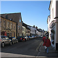
Bury St Edmunds: Churchgate Street
A view from the corner of Athenaeum Lane taken late in the morning of a sunny day in February.
Image: © John Sutton
Taken: 17 Feb 2015
0.01 miles
5
![Bury St Edmunds houses [47]](https://s2.geograph.org.uk/geophotos/06/65/68/6656802_a7548394_120x120.jpg)
Bury St Edmunds houses [47]
The building containing numbers 32 and 33 Churchgate is one house, later divided into two, but half of number 33 (nearest the camera) was part of number 34 Image and dates from the 16th century. Number 32 and the other half of number 33 are 17th century. The building is timber framed and was refronted in the 19th century in roughcast. The former shop fronts are 19th century and there is a 17th century rear extension and others of various dates. Number 33 has a room on the upper floor which can only accessed from number 34. Listed, grade II, with details at: https://historicengland.org.uk/listing/the-list/list-entry/1248203
Churchgate Street is aligned with the Norman Tower entrance to the Abbey and would have been the ceremonial route between the Abbey and the Guildhall, the spiritual and the temporal. The street has some of the town’s most important historic buildings with structures dating back to the 13th century.
Bury St Edmunds is a market town which is the cultural and retail centre for West Suffolk and is known for brewing (Greene King) and sugar (British Sugar). There is scattered evidence of earlier activity but essentially Bury St Edmunds began as one of the royal boroughs of the Saxons and a monastery was founded which became the burial place of King Edmund. A new Benedictine abbey was built in 1020 which became rich and powerful and the town was laid out on a grid pattern by Abbot Baldwin. After the dissolution the abbey became ruinous. A new church, later the cathedral, was begun in the early 16th century.
Image: © Michael Dibb
Taken: 12 Sep 2020
0.01 miles
6
![Bury St Edmunds houses [46]](https://s0.geograph.org.uk/geophotos/06/65/57/6655784_9d7ae368_120x120.jpg)
Bury St Edmunds houses [46]
Number 27 Churchgate Street has a 17th century core. It was modernised circa 1690 and again in the early 18th century when it was refronted. Timber-framed, fronted in 2 shades of red brick and roughcast-rendered to the sides and rear. Some fine original internal features remain. Listed, grade II, with details at: https://historicengland.org.uk/listing/the-list/list-entry/1248119
Churchgate Street is aligned with the Norman Tower entrance to the Abbey and would have been the ceremonial route between the Abbey and the Guildhall, the spiritual and the temporal. The street has some of the town’s most important historic buildings with structures dating back to the 13th century.
Bury St Edmunds is a market town which is the cultural and retail centre for West Suffolk and is known for brewing (Greene King) and sugar (British Sugar). There is scattered evidence of earlier activity but essentially Bury St Edmunds began as one of the royal boroughs of the Saxons and a monastery was founded which became the burial place of King Edmund. A new Benedictine abbey was built in 1020 which became rich and powerful and the town was laid out on a grid pattern by Abbot Baldwin. After the dissolution the abbey became ruinous. A new church, later the cathedral, was begun in the early 16th century.
Image: © Michael Dibb
Taken: 12 Sep 2020
0.01 miles
7
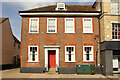
Abbey House, 27 Churchgate Street
Grade II listed 17th century timber framed house, with an early 19th century brick front
Image: © Richard Croft
Taken: 11 Sep 2023
0.01 miles
8
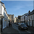
Bury St Edmunds: Churchgate Street
Looking towards the Norman Tower from the corner of Hatter Street on a sunny January morning.
Image: © John Sutton
Taken: 23 Jan 2015
0.01 miles
9
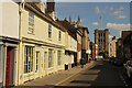
Churchgate Street
Historic street in Bury St. Edmunds
Image: © Richard Croft
Taken: 11 Sep 2023
0.02 miles
10
![Bury St Edmunds buildings [64]](https://s0.geograph.org.uk/geophotos/06/65/68/6656808_e13b3046_120x120.jpg)
Bury St Edmunds buildings [64]
Undergoing repairs, the house and shop at number 34 Churchgate Street, partly has a 16th century core overlapping with number 33 Image The rest is early 18th century, timber framed and stuccoed, with 19th century alterations. On a corner site, there is a long side frontage to Angel Lane. There are a number of original 18th century internal features remaining. Listed, grade II, with details at: https://historicengland.org.uk/listing/the-list/list-entry/1248203
Churchgate Street is aligned with the Norman Tower entrance to the Abbey and would have been the ceremonial route between the Abbey and the Guildhall, the spiritual and the temporal. The street has some of the town’s most important historic buildings with structures dating back to the 13th century.
Bury St Edmunds is a market town which is the cultural and retail centre for West Suffolk and is known for brewing (Greene King) and sugar (British Sugar). There is scattered evidence of earlier activity but essentially Bury St Edmunds began as one of the royal boroughs of the Saxons and a monastery was founded which became the burial place of King Edmund. A new Benedictine abbey was built in 1020 which became rich and powerful and the town was laid out on a grid pattern by Abbot Baldwin. After the dissolution the abbey became ruinous. A new church, later the cathedral, was begun in the early 16th century.
Image: © Michael Dibb
Taken: 12 Sep 2020
0.02 miles