Bury St Edmunds houses [47]
Introduction
The photograph on this page of Bury St Edmunds houses [47] by Michael Dibb as part of the Geograph project.
The Geograph project started in 2005 with the aim of publishing, organising and preserving representative images for every square kilometre of Great Britain, Ireland and the Isle of Man.

There are currently over 7.5m images from over 14,400 individuals and you can help contribute to the project by visiting https://www.geograph.org.uk
Bury St Edmunds houses [47]
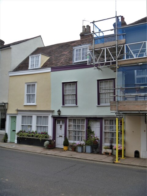
Image: © Michael Dibb Taken: 12 Sep 2020
The building containing numbers 32 and 33 Churchgate is one house, later divided into two, but half of number 33 (nearest the camera) was part of number 34 Image and dates from the 16th century. Number 32 and the other half of number 33 are 17th century. The building is timber framed and was refronted in the 19th century in roughcast. The former shop fronts are 19th century and there is a 17th century rear extension and others of various dates. Number 33 has a room on the upper floor which can only accessed from number 34. Listed, grade II, with details at: https://historicengland.org.uk/listing/the-list/list-entry/1248203 Churchgate Street is aligned with the Norman Tower entrance to the Abbey and would have been the ceremonial route between the Abbey and the Guildhall, the spiritual and the temporal. The street has some of the town’s most important historic buildings with structures dating back to the 13th century. Bury St Edmunds is a market town which is the cultural and retail centre for West Suffolk and is known for brewing (Greene King) and sugar (British Sugar). There is scattered evidence of earlier activity but essentially Bury St Edmunds began as one of the royal boroughs of the Saxons and a monastery was founded which became the burial place of King Edmund. A new Benedictine abbey was built in 1020 which became rich and powerful and the town was laid out on a grid pattern by Abbot Baldwin. After the dissolution the abbey became ruinous. A new church, later the cathedral, was begun in the early 16th century.
Images are licensed for reuse under creativecommons.org/licenses/by-sa/2.0
Image Location
Latitude
52.243464
Longitude
0.715315