
IMAGES TAKEN NEAR TO
Chequer Square, BURY ST. EDMUNDS, IP33 1QZ
Introduction
This page details the photographs taken nearby to Chequer Square, IP33 1QZ by members of the Geograph project.
The Geograph project started in 2005 with the aim of publishing, organising and preserving representative images for every square kilometre of Great Britain, Ireland and the Isle of Man.

There are currently over 7.5m images from over14,400 individuals and you can help contribute to the project by visiting https://www.geograph.org.uk
Image Map
Images are licensed for reuse under creativecommons.org/licenses/by-sa/2.0
Notes
- Clicking on the map will re-center to the selected point.
- The higher the marker number, the further away the image location is from the centre of the postcode.
Image Listing (1946 Images Found)
Images are licensed for reuse under creativecommons.org/licenses/by-sa/2.0
Image
Details
Distance
1
![Bury St Edmunds houses [39]](https://s2.geograph.org.uk/geophotos/06/65/45/6654506_631be20d_120x120.jpg)
Bury St Edmunds houses [39]
Baret House, number 3 Chequer Square, is an important, large, late medieval town house with earlier origins and later alterations. The house is timber framed and was refronted in white brick circa 1813 when the roof was raised. There is remains of a 14th century core, a 15th century lodging range and a hall range and other alterations circa 1500. There was more remodelling in the late late 17th century and circa 1813. The garden front is in red brick and a 2-storey 15th century timber-framed rear gallery range, at right-angles, is faced in late 17th century red brick. As well as much high quality timber framing, important surviving features include a 14th century doorway; the mid 15th century priests lodging range; the fine hall ceiling of circa 1500; very significant painted decoration on the circa 1500 chimney stack. Listed, grade II*, with details at: https://historicengland.org.uk/listing/the-list/list-entry/1248046
Crown Street is an historic street that starts with a brewery and finishes with a cathedral, has a medieval graveyard, the second largest parish church in the country and houses from the 16th to the 19th centuries. At its north end it opens out to become Chequer Square.
Bury St Edmunds is a market town which is the cultural and retail centre for West Suffolk and is known for brewing (Greene King) and sugar (British Sugar). There is scattered evidence of earlier activity but essentially Bury St Edmunds began as one of the royal boroughs of the Saxons and a monastery was founded which became the burial place of King Edmund. A new Benedictine abbey was built in 1020 which became rich and powerful and the town was laid out on a grid pattern by Abbot Baldwin. After the dissolution the abbey became ruinous. A new church, later the cathedral, was begun in the early 16th century.
Image: © Michael Dibb
Taken: 11 Sep 2020
0.00 miles
2
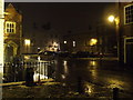
Chequer Square
Chequer Square Bury St.Edmunds, Suffolk at night.
Image: © Keith Evans
Taken: 2 Feb 2009
0.01 miles
3
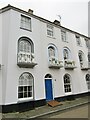
Bury St Edmunds - Crown Street
Historic housing terrace with ornate iron balconies.
www.visit-burystedmunds.co.uk
Image: © Colin Smith
Taken: 14 Aug 2020
0.01 miles
4
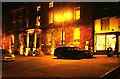
Angel Hotel by night
The Angel Hotel is on Angel Hill - not sure which one came first.
Over the years it has housed many famous people, from Charles Dickens to Nick Cave.
Image: © John Goldsmith
Taken: 17 Nov 2011
0.01 miles
5
![Bury St Edmunds houses [40]](https://s1.geograph.org.uk/geophotos/06/65/45/6654557_cfd7d08b_120x120.jpg)
Bury St Edmunds houses [40]
Chequer House, 3 Chequer Square has a circa 1700 core from the Chequer Inn which formerly stood on the site. Rebuilt in white brick in the early 19th century with a rear extension of the late 19th century. The house is now divided into flats. There is a very fine late 17th or early 18th century open well stair which rises the whole height of the house and ends in a balustrade on the landing of the top storey. Listed, grade II, with details at: https://historicengland.org.uk/listing/the-list/list-entry/1248047
Crown Street is an historic street that starts with a brewery and finishes with a cathedral, has a medieval graveyard, the second largest parish church in the country and houses from the 16th to the 19th centuries. At its north end it opens out to become Chequer Square.
Bury St Edmunds is a market town which is the cultural and retail centre for West Suffolk and is known for brewing (Greene King) and sugar (British Sugar). There is scattered evidence of earlier activity but essentially Bury St Edmunds began as one of the royal boroughs of the Saxons and a monastery was founded which became the burial place of King Edmund. A new Benedictine abbey was built in 1020 which became rich and powerful and the town was laid out on a grid pattern by Abbot Baldwin. After the dissolution the abbey became ruinous. A new church, later the cathedral, was begun in the early 16th century.
Image: © Michael Dibb
Taken: 11 Sep 2020
0.01 miles
7
![Bury St Edmunds houses [38]](https://s3.geograph.org.uk/geophotos/06/65/43/6654351_40ec1f9d_120x120.jpg)
Bury St Edmunds houses [38]
Numbers 1 and 2 Chequer Square are joined via a splayed corner to number 50 Crown Street Image Built in 1840 in stuccoed brick with attractive windows with semicircular arched heads with radiating glazing-bars. The first floor have cast iron balconies. Listed, grade II, with details at: https://historicengland.org.uk/listing/the-list/list-entry/1248045
Crown Street is an historic street that starts with a brewery and finishes with a cathedral, has a medieval graveyard, the second largest parish church in the country and houses from the 16th to the 19th centuries. At its north end it opens out to become Chequer Square.
Bury St Edmunds is a market town which is the cultural and retail centre for West Suffolk and is known for brewing (Greene King) and sugar (British Sugar). There is scattered evidence of earlier activity but essentially Bury St Edmunds began as one of the royal boroughs of the Saxons and a monastery was founded which became the burial place of King Edmund. A new Benedictine abbey was built in 1020 which became rich and powerful and the town was laid out on a grid pattern by Abbot Baldwin. After the dissolution the abbey became ruinous. A new church, later the cathedral, was begun in the early 16th century.
Image: © Michael Dibb
Taken: 11 Sep 2020
0.01 miles
8
![Bury St Edmunds features [6]](https://s2.geograph.org.uk/geophotos/06/65/46/6654630_b5ba03da_120x120.jpg)
Bury St Edmunds features [6]
The Obelisk, an 18th century stone needle stands in Chequer Square. Listed, grade II, with details at: https://historicengland.org.uk/listing/the-list/list-entry/1248048
Crown Street is an historic street that starts with a brewery and finishes with a cathedral, has a medieval graveyard, the second largest parish church in the country and houses from the 16th to the 19th centuries. At its north end it opens out to become Chequer Square.
Bury St Edmunds is a market town which is the cultural and retail centre for West Suffolk and is known for brewing (Greene King) and sugar (British Sugar). There is scattered evidence of earlier activity but essentially Bury St Edmunds began as one of the royal boroughs of the Saxons and a monastery was founded which became the burial place of King Edmund. A new Benedictine abbey was built in 1020 which became rich and powerful and the town was laid out on a grid pattern by Abbot Baldwin. After the dissolution the abbey became ruinous. A new church, later the cathedral, was begun in the early 16th century.
Image: © Michael Dibb
Taken: 11 Sep 2020
0.01 miles
9
![Bury St Edmunds houses [34]](https://s3.geograph.org.uk/geophotos/06/65/42/6654279_2bacf14a_120x120.jpg)
Bury St Edmunds houses [34]
Number 50 Crown Street also has a frontage onto Chequer Square (see Image). Built in 1840 in stuccoed brick with attractive windows with semicircular arched heads with radiating glazing-bars. The frontage to Chequer Square has a first floor cast iron balcony. Listed, grade II, with details at: https://historicengland.org.uk/listing/the-list/list-entry/1342764
Crown Street is an historic street that starts with a brewery and finishes with a cathedral, has a medieval graveyard, the second largest parish church in the country and houses from the 16th to the 19th centuries.
Bury St Edmunds is a market town which is the cultural and retail centre for West Suffolk and is known for brewing (Greene King) and sugar (British Sugar). There is scattered evidence of earlier activity but essentially Bury St Edmunds began as one of the royal boroughs of the Saxons and a monastery was founded which became the burial place of King Edmund. A new Benedictine abbey was built in 1020 which became rich and powerful and the town was laid out on a grid pattern by Abbot Baldwin. After the dissolution the abbey became ruinous. A new church, later the cathedral, was begun in the early 16th century.
Image: © Michael Dibb
Taken: 11 Sep 2020
0.01 miles
10
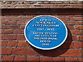
Blue plaque in Crown Street
Also see https://en.wikipedia.org/wiki/Lewis_Nockalls_Cottingham
Image: © Basher Eyre
Taken: 31 Jul 2016
0.01 miles