IMAGES TAKEN NEAR TO
Guildhall Street, BURY ST. EDMUNDS, IP33 1QD
Introduction
This page details the photographs taken nearby to Guildhall Street, IP33 1QD by members of the Geograph project.
The Geograph project started in 2005 with the aim of publishing, organising and preserving representative images for every square kilometre of Great Britain, Ireland and the Isle of Man.

There are currently over 7.5m images from over14,400 individuals and you can help contribute to the project by visiting https://www.geograph.org.uk
Image Map
Images are licensed for reuse under creativecommons.org/licenses/by-sa/2.0
Notes
- Clicking on the map will re-center to the selected point.
- The higher the marker number, the further away the image location is from the centre of the postcode.
Image Listing (1714 Images Found)
Images are licensed for reuse under creativecommons.org/licenses/by-sa/2.0
Image
Details
Distance
1
![Bury St Edmunds houses [63]](https://s0.geograph.org.uk/geophotos/06/65/95/6659528_5e6c03d6_120x120.jpg)
Bury St Edmunds houses [63]
Numbers 22 and 23 Guildhall Street were originally one house, now two. The core is 17th century, timber framed and stuccoed. The house was altered in the 18th century and divided into two in the early 19th century. Both houses have long rear extensions. Number 22 was restored in 1994. Some 18th century features remain. Listed, grade II, with details at: https://historicengland.org.uk/listing/the-list/list-entry/1363703
Guildhall Street is one of the north-south streets laid out in the 12th century. There is a rich mix of high quality buildings, especially at the commercial, northern end with a fine mix of houses at the residential, southern end. The Guildhall is a Norman building which is the oldest continuously used Civic building in the country.
Bury St Edmunds is a market town which is the cultural and retail centre for West Suffolk and is known for brewing (Greene King) and sugar (British Sugar). There is scattered evidence of earlier activity but essentially Bury St Edmunds began as one of the royal boroughs of the Saxons and a monastery was founded which became the burial place of King Edmund. A new Benedictine abbey was built in 1020 which became rich and powerful and the town was laid out on a grid pattern by Abbot Baldwin. After the dissolution the abbey became ruinous. A new church, later the cathedral, was begun in the early 16th century.
Image: © Michael Dibb
Taken: 13 Sep 2020
0.01 miles
2
![Bury St Edmunds houses [64]](https://s2.geograph.org.uk/geophotos/06/65/95/6659534_27bab6d8_120x120.jpg)
Bury St Edmunds houses [64]
Numbers 24, 25 and 26 Guildhall Street are a row of three early 19th century houses. The fronts are in white brick, the rears are in flint and red brick. Some original internal features remain. Listed, grade II, with details at: https://historicengland.org.uk/listing/the-list/list-entry/1363727
Guildhall Street is one of the north-south streets laid out in the 12th century. There is a rich mix of high quality buildings, especially at the commercial, northern end with a fine mix of houses at the residential, southern end. The Guildhall is a Norman building which is the oldest continuously used Civic building in the country.
Bury St Edmunds is a market town which is the cultural and retail centre for West Suffolk and is known for brewing (Greene King) and sugar (British Sugar). There is scattered evidence of earlier activity but essentially Bury St Edmunds began as one of the royal boroughs of the Saxons and a monastery was founded which became the burial place of King Edmund. A new Benedictine abbey was built in 1020 which became rich and powerful and the town was laid out on a grid pattern by Abbot Baldwin. After the dissolution the abbey became ruinous. A new church, later the cathedral, was begun in the early 16th century.
Image: © Michael Dibb
Taken: 13 Sep 2020
0.01 miles
3
![Bury St Edmunds buildings [138]](https://s3.geograph.org.uk/geophotos/06/67/26/6672675_9dea7e5a_120x120.jpg)
Bury St Edmunds buildings [138]
Set back from the street and at right angles to it is number 64 Whiting Street. Built as a snuff and tobacco factory, later a piano workshop and salesroom and now a domestic residence. Built in the 18th century in flint with red brick dressings and a mansard roof. The listing includes the wall between numbers 64 and 65. Listed, grade II, with details at: https://historicengland.org.uk/listing/the-list/list-entry/1096753
Whiting Street is one of the north-south streets laid out by Abbot Baldwin in the 12th century and has buildings from the early medieval to the late 20th century. The street is divided by Churchgate Street at its midpoint and the character is mainly residential to the southern part with a mixture of residential with retail and commercial uses to the northern part.
Bury St Edmunds is a market town which is the cultural and retail centre for West Suffolk and is known for brewing (Greene King) and sugar (British Sugar). There is scattered evidence of earlier activity but essentially Bury St Edmunds began as one of the royal boroughs of the Saxons and a monastery was founded which became the burial place of King Edmund. A new Benedictine abbey was built in 1020 which became rich and powerful and the town was laid out on a grid pattern by Abbot Baldwin. After the dissolution the abbey became ruinous. A new church, later the cathedral, was begun in the early 16th century.
Image: © Michael Dibb
Taken: 12 Sep 2020
0.01 miles
4
![Bury St Edmunds houses [85]](https://s3.geograph.org.uk/geophotos/06/66/25/6662515_37ee9e74_120x120.jpg)
Bury St Edmunds houses [85]
Number 72 Guildhall Street has a 17th century rear range and an 18th century front range. Timber framed with raised roughcast panels and a mansard roof. There is a 19th century rear extension. Listed, grade II, with details at: https://historicengland.org.uk/listing/the-list/list-entry/1363708
Guildhall Street is one of the north-south streets laid out in the 12th century. There is a rich mix of high quality buildings, especially at the commercial, northern end with a fine mix of houses at the residential, southern end. The Guildhall is a Norman building which is the oldest continuously used Civic building in the country.
Bury St Edmunds is a market town which is the cultural and retail centre for West Suffolk and is known for brewing (Greene King) and sugar (British Sugar). There is scattered evidence of earlier activity but essentially Bury St Edmunds began as one of the royal boroughs of the Saxons and a monastery was founded which became the burial place of King Edmund. A new Benedictine abbey was built in 1020 which became rich and powerful and the town was laid out on a grid pattern by Abbot Baldwin. After the dissolution the abbey became ruinous. A new church, later the cathedral, was begun in the early 16th century.
Image: © Michael Dibb
Taken: 13 Sep 2020
0.01 miles
5
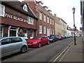
Guildhall St
Mostly handsome Georgian townhouses and the Black Boy pub. http://www.theblackboypublichouse.co.uk/
Image: © HelenK
Taken: 25 Oct 2015
0.01 miles
6
![Bury St Edmunds houses [86]](https://s0.geograph.org.uk/geophotos/06/66/25/6662516_6a945846_120x120.jpg)
Bury St Edmunds houses [86]
Number 73 Guildhall Street is 17th century refronted in the 18th century. Timber framed and raised roughcast panels. Extensive cellars have some 16th century rough walling. The house was extensively restored in the 1950s. Listed, grade II, with details at: https://historicengland.org.uk/listing/the-list/list-entry/1363709
Guildhall Street is one of the north-south streets laid out in the 12th century. There is a rich mix of high quality buildings, especially at the commercial, northern end with a fine mix of houses at the residential, southern end. The Guildhall is a Norman building which is the oldest continuously used Civic building in the country.
Bury St Edmunds is a market town which is the cultural and retail centre for West Suffolk and is known for brewing (Greene King) and sugar (British Sugar). There is scattered evidence of earlier activity but essentially Bury St Edmunds began as one of the royal boroughs of the Saxons and a monastery was founded which became the burial place of King Edmund. A new Benedictine abbey was built in 1020 which became rich and powerful and the town was laid out on a grid pattern by Abbot Baldwin. After the dissolution the abbey became ruinous. A new church, later the cathedral, was begun in the early 16th century.
Image: © Michael Dibb
Taken: 13 Sep 2020
0.01 miles
7
![Bury St Edmunds houses [62]](https://s3.geograph.org.uk/geophotos/06/65/95/6659503_6a43cbfc_120x120.jpg)
Bury St Edmunds houses [62]
Numbers 20 and 21 Guildhall Street are a pair of houses built circa 1860 in white brick. Listed, grade II, with details at: https://historicengland.org.uk/listing/the-list/list-entry/1363702
Guildhall Street is one of the north-south streets laid out in the 12th century. There is a rich mix of high quality buildings, especially at the commercial, northern end with a fine mix of houses at the residential, southern end. The Guildhall is a Norman building which is the oldest continuously used Civic building in the country.
Bury St Edmunds is a market town which is the cultural and retail centre for West Suffolk and is known for brewing (Greene King) and sugar (British Sugar). There is scattered evidence of earlier activity but essentially Bury St Edmunds began as one of the royal boroughs of the Saxons and a monastery was founded which became the burial place of King Edmund. A new Benedictine abbey was built in 1020 which became rich and powerful and the town was laid out on a grid pattern by Abbot Baldwin. After the dissolution the abbey became ruinous. A new church, later the cathedral, was begun in the early 16th century.
Image: © Michael Dibb
Taken: 13 Sep 2020
0.01 miles
8
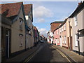
Guildhall St, Bury St Edmunds, Suffolk
British Legion on the lefthand side of picture
Image: © Andrew Norburn
Taken: 22 Jan 2007
0.02 miles
9
![Bury St Edmunds houses [84]](https://s2.geograph.org.uk/geophotos/06/66/25/6662514_2f57fc2d_120x120.jpg)
Bury St Edmunds houses [84]
This large house at number 71 Guildhall Street is early 19th century in white brick to the front and red brick to the rear. There are several 20th century extensions. Many original early 19th century internal features remain. Listed, grade II, with details at: https://historicengland.org.uk/listing/the-list/list-entry/1363707
Guildhall Street is one of the north-south streets laid out in the 12th century. There is a rich mix of high quality buildings, especially at the commercial, northern end with a fine mix of houses at the residential, southern end. The Guildhall is a Norman building which is the oldest continuously used Civic building in the country.
Bury St Edmunds is a market town which is the cultural and retail centre for West Suffolk and is known for brewing (Greene King) and sugar (British Sugar). There is scattered evidence of earlier activity but essentially Bury St Edmunds began as one of the royal boroughs of the Saxons and a monastery was founded which became the burial place of King Edmund. A new Benedictine abbey was built in 1020 which became rich and powerful and the town was laid out on a grid pattern by Abbot Baldwin. After the dissolution the abbey became ruinous. A new church, later the cathedral, was begun in the early 16th century.
Image: © Michael Dibb
Taken: 13 Sep 2020
0.02 miles
10
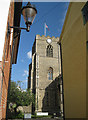
St Mary's Church, Bury St Edmunds
This church claims to be the third largest parish church in England, as well as having the second longest aisle. This view is from Church Walks, a narrow lane that links Crown Street and Bridewell Lane.
Image: © Bob Jones
Taken: 18 Sep 2012
0.02 miles