IMAGES TAKEN NEAR TO
Woolhall Street, BURY ST. EDMUNDS, IP33 1LA
Introduction
This page details the photographs taken nearby to Woolhall Street, IP33 1LA by members of the Geograph project.
The Geograph project started in 2005 with the aim of publishing, organising and preserving representative images for every square kilometre of Great Britain, Ireland and the Isle of Man.

There are currently over 7.5m images from over14,400 individuals and you can help contribute to the project by visiting https://www.geograph.org.uk
Image Map
Images are licensed for reuse under creativecommons.org/licenses/by-sa/2.0
Notes
- Clicking on the map will re-center to the selected point.
- The higher the marker number, the further away the image location is from the centre of the postcode.
Image Listing (1273 Images Found)
Images are licensed for reuse under creativecommons.org/licenses/by-sa/2.0
Image
Details
Distance
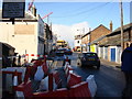
2
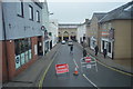
Woolhall Street from Corn Exchange
In the 1960s the Corn Exchange building was preserved by inserting a mezzanine floor for a public meeting and performance space upstairs, and shops below. This view from a window shows Woolhall Street, probably Bury's shortest, ending at the sharp roofed battleship grey of part of the arc development. Caaroline's dress shop has closed since this photo, having lasted only a few months. The BetFred premises used to be the Job Centre.
Image: © John Goldsmith
Taken: 9 Sep 2009
0.01 miles
3
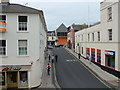
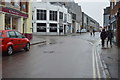
Night club corner, Bury St Edmunds
As a town hardly renowned for its night clubs, Bury St Edmunds now has two opposite each other - and in the centre of town. The red building is 'Deja Vu' (without the accents). The building on the other side of the road is known as 'Ruin'. These two buildings are located at the junction of Kings Road, Woolhall Street and St Andrew's Street South.
Image: © Bob Jones
Taken: 3 Feb 2009
0.01 miles
6
![Bury St Edmunds buildings [84]](https://s3.geograph.org.uk/geophotos/06/66/31/6663195_715faf60_120x120.jpg)
Bury St Edmunds buildings [84]
Bank Chambers, number 90 Guildhall Street was, until 2017, a branch of the Royal Bank of Scotland. There is a late 17th century timber framed core with a stuccoed early 19th century front. The building was modernised and altered in the 1980s. An entrance door on the extreme left is structurally part of Number 89 Image Listed, grade II, with details at: https://historicengland.org.uk/listing/the-list/list-entry/1363725
Guildhall Street is one of the north-south streets laid out in the 12th century. There is a rich mix of high quality buildings, especially at the commercial, northern end with a fine mix of houses at the residential, southern end. The Guildhall is a Norman building which is the oldest continuously used Civic building in the country.
Bury St Edmunds is a market town which is the cultural and retail centre for West Suffolk and is known for brewing (Greene King) and sugar (British Sugar). There is scattered evidence of earlier activity but essentially Bury St Edmunds began as one of the royal boroughs of the Saxons and a monastery was founded which became the burial place of King Edmund. A new Benedictine abbey was built in 1020 which became rich and powerful and the town was laid out on a grid pattern by Abbot Baldwin. After the dissolution the abbey became ruinous. A new church, later the cathedral, was begun in the early 16th century.
Image: © Michael Dibb
Taken: 13 Sep 2020
0.03 miles
8
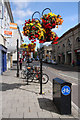
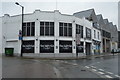
Street furniture, Bury St Edmunds
Floral baskets decorate the street scene at the junction of Guildhall Street and Abbeygate Street. To the right is the Corn Exchange, where events and conferences are held.
Image: © Bob Jones
Taken: 31 Jul 2009
0.03 miles
10
![Bury St Edmunds houses [95]](https://s2.geograph.org.uk/geophotos/06/66/31/6663186_fe13e3a2_120x120.jpg)
Bury St Edmunds houses [95]
This large house at number 88 Guildhall Street was used as offices for many decades and has recently been restored as a private dwelling. Built in the 17th century, timber framed and stuccoed there is a long 18th century timber framed rear extension. Some original internal features survive. Listed, grade II, with details at: https://historicengland.org.uk/listing/the-list/list-entry/1363723
Guildhall Street is one of the north-south streets laid out in the 12th century. There is a rich mix of high quality buildings, especially at the commercial, northern end with a fine mix of houses at the residential, southern end. The Guildhall is a Norman building which is the oldest continuously used Civic building in the country.
Bury St Edmunds is a market town which is the cultural and retail centre for West Suffolk and is known for brewing (Greene King) and sugar (British Sugar). There is scattered evidence of earlier activity but essentially Bury St Edmunds began as one of the royal boroughs of the Saxons and a monastery was founded which became the burial place of King Edmund. A new Benedictine abbey was built in 1020 which became rich and powerful and the town was laid out on a grid pattern by Abbot Baldwin. After the dissolution the abbey became ruinous. A new church, later the cathedral, was begun in the early 16th century.
Image: © Michael Dibb
Taken: 13 Sep 2020
0.03 miles