IMAGES TAKEN NEAR TO
Garland Street, BURY ST. EDMUNDS, IP33 1HB
Introduction
This page details the photographs taken nearby to Garland Street, IP33 1HB by members of the Geograph project.
The Geograph project started in 2005 with the aim of publishing, organising and preserving representative images for every square kilometre of Great Britain, Ireland and the Isle of Man.

There are currently over 7.5m images from over14,400 individuals and you can help contribute to the project by visiting https://www.geograph.org.uk
Image Map
Images are licensed for reuse under creativecommons.org/licenses/by-sa/2.0
Notes
- Clicking on the map will re-center to the selected point.
- The higher the marker number, the further away the image location is from the centre of the postcode.
Image Listing (897 Images Found)
Images are licensed for reuse under creativecommons.org/licenses/by-sa/2.0
Image
Details
Distance
1
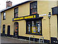
Church Row, Bury St Edmunds, Suffolk
Hardcore Hobbies is a shop on the corner of Church Row.
Image: © Christine Matthews
Taken: 8 May 2010
0.04 miles
2
St John Street, Bury St Edmunds, Suffolk
Looking down St John Street from the corner of Brentgovel Street.
Image: © Christine Matthews
Taken: 8 May 2010
0.05 miles
3
![Bury St Edmunds houses [233]](https://s2.geograph.org.uk/geophotos/06/68/67/6686742_e4f5d661_120x120.jpg)
Bury St Edmunds houses [233]
Numbers 21 and 22 Well Street were built in the early to mid 19th century in knapped flint with white brick dressings. The former coach house, part of number 22, is now a garage. Listed, grade II, with details at: https://historicengland.org.uk/listing/the-list/list-entry/1365877
North of the town centre Northgate Street and St John’s Street run towards the site of Northgate and the railway station and both streets have many older buildings. In between these two streets is a number of streets irregularly laid out (compared to the medieval grid of the town centre) containing mostly houses and buildings from the 19th century.
Bury St Edmunds is a market town which is the cultural and retail centre for West Suffolk and is known for brewing (Greene King) and sugar (British Sugar). There is scattered evidence of earlier activity but essentially Bury St Edmunds began as one of the royal boroughs of the Saxons and a monastery was founded which became the burial place of King Edmund. A new Benedictine abbey was built in 1020 which became rich and powerful and the town was laid out on a grid pattern by Abbot Baldwin. After the dissolution the abbey became ruinous. A new church, later the cathedral, was begun in the early 16th century.
Image: © Michael Dibb
Taken: 10 Sep 2020
0.05 miles
4
![Bury St Edmunds houses [232]](https://s1.geograph.org.uk/geophotos/06/68/67/6686741_eef3128f_120x120.jpg)
Bury St Edmunds houses [232]
Set back slightly from the street, number 20 Well Street was built in the early 19th century in knapped flint with white brick dressings. The low front railings and gate have ornate pierced heads to the balusters. Listed, grade II, with details at: https://historicengland.org.uk/listing/the-list/list-entry/1365875
North of the town centre Northgate Street and St John’s Street run towards the site of Northgate and the railway station and both streets have many older buildings. In between these two streets is a number of streets irregularly laid out (compared to the medieval grid of the town centre) containing mostly houses and buildings from the 19th century.
Bury St Edmunds is a market town which is the cultural and retail centre for West Suffolk and is known for brewing (Greene King) and sugar (British Sugar). There is scattered evidence of earlier activity but essentially Bury St Edmunds began as one of the royal boroughs of the Saxons and a monastery was founded which became the burial place of King Edmund. A new Benedictine abbey was built in 1020 which became rich and powerful and the town was laid out on a grid pattern by Abbot Baldwin. After the dissolution the abbey became ruinous. A new church, later the cathedral, was begun in the early 16th century.
Image: © Michael Dibb
Taken: 10 Sep 2020
0.05 miles
5
![Bury St Edmunds houses [234]](https://s3.geograph.org.uk/geophotos/06/68/67/6686743_307aa087_120x120.jpg)
Bury St Edmunds houses [234]
Number 23 Well Street is a three stoey house in red brick. Built in the mid 19th century with front and rear ranges, the rear range with a mansard roof. Listed, grade II, with details at: https://historicengland.org.uk/listing/the-list/list-entry/1365878
North of the town centre Northgate Street and St John’s Street run towards the site of Northgate and the railway station and both streets have many older buildings. In between these two streets is a number of streets irregularly laid out (compared to the medieval grid of the town centre) containing mostly houses and buildings from the 19th century.
Bury St Edmunds is a market town which is the cultural and retail centre for West Suffolk and is known for brewing (Greene King) and sugar (British Sugar). There is scattered evidence of earlier activity but essentially Bury St Edmunds began as one of the royal boroughs of the Saxons and a monastery was founded which became the burial place of King Edmund. A new Benedictine abbey was built in 1020 which became rich and powerful and the town was laid out on a grid pattern by Abbot Baldwin. After the dissolution the abbey became ruinous. A new church, later the cathedral, was begun in the early 16th century.
Image: © Michael Dibb
Taken: 10 Sep 2020
0.06 miles
6
![Bury St Edmunds houses [235]](https://s1.geograph.org.uk/geophotos/06/68/67/6686745_cdb12b52_120x120.jpg)
Bury St Edmunds houses [235]
This terrace of four houses, numbers 24 to 27 Well Street, was built in the mid 19th century with white brick to the front and red brick to the sides and rear. Listed, grade II, with details at: https://historicengland.org.uk/listing/the-list/list-entry/1365880
North of the town centre Northgate Street and St John’s Street run towards the site of Northgate and the railway station and both streets have many older buildings. In between these two streets is a number of streets irregularly laid out (compared to the medieval grid of the town centre) containing mostly houses and buildings from the 19th century.
Bury St Edmunds is a market town which is the cultural and retail centre for West Suffolk and is known for brewing (Greene King) and sugar (British Sugar). There is scattered evidence of earlier activity but essentially Bury St Edmunds began as one of the royal boroughs of the Saxons and a monastery was founded which became the burial place of King Edmund. A new Benedictine abbey was built in 1020 which became rich and powerful and the town was laid out on a grid pattern by Abbot Baldwin. After the dissolution the abbey became ruinous. A new church, later the cathedral, was begun in the early 16th century.
Image: © Michael Dibb
Taken: 10 Sep 2020
0.06 miles
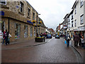
7
Orchard Street, Bury St Edmunds
Viewed from its junction with Short Brackland and Cannon Street, Orchard Street contains close-packed terraced housing. At the end of the street is the imposing church of St John the Evangelist, affectionately known locally as the 'Skyrocket', for obvious reasons.
Image: © Bob Jones
Taken: 7 Mar 2011
0.06 miles
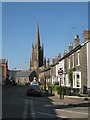
8
Church Row, Bury St Edmunds, Suffolk
Looking east down Church Row.
Image: © Christine Matthews
Taken: 8 May 2010
0.06 miles
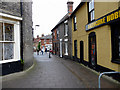
9
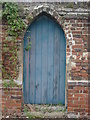
Door, Pump Lane
Aerial imagery on Multimap shows that this door leads to a large garden.
Image: © Oxyman
Taken: 11 Apr 2009
0.07 miles
10
![Bury St Edmunds houses [231]](https://s0.geograph.org.uk/geophotos/06/68/67/6686740_05a52602_120x120.jpg)
Bury St Edmunds houses [231]
Number 15 Well Street is one of a pair of identical detached houses (number 14 Well Street is the other Image). Built in the mid 19th century with white brick to the front and red brick to the sides and rear. Listed, grade II, with details at: https://historicengland.org.uk/listing/the-list/list-entry/1365871
North of the town centre Northgate Street and St John’s Street run towards the site of Northgate and the railway station and both streets have many older buildings. In between these two streets is a number of streets irregularly laid out (compared to the medieval grid of the town centre) containing mostly houses and buildings from the 19th century.
Bury St Edmunds is a market town which is the cultural and retail centre for West Suffolk and is known for brewing (Greene King) and sugar (British Sugar). There is scattered evidence of earlier activity but essentially Bury St Edmunds began as one of the royal boroughs of the Saxons and a monastery was founded which became the burial place of King Edmund. A new Benedictine abbey was built in 1020 which became rich and powerful and the town was laid out on a grid pattern by Abbot Baldwin. After the dissolution the abbey became ruinous. A new church, later the cathedral, was begun in the early 16th century.
Image: © Michael Dibb
Taken: 10 Sep 2020
0.07 miles