IMAGES TAKEN NEAR TO
Tupman Walk, BURY ST. EDMUNDS, IP33 1AJ
Introduction
This page details the photographs taken nearby to Tupman Walk, IP33 1AJ by members of the Geograph project.
The Geograph project started in 2005 with the aim of publishing, organising and preserving representative images for every square kilometre of Great Britain, Ireland and the Isle of Man.

There are currently over 7.5m images from over14,400 individuals and you can help contribute to the project by visiting https://www.geograph.org.uk
Image Map
Images are licensed for reuse under creativecommons.org/licenses/by-sa/2.0
Notes
- Clicking on the map will re-center to the selected point.
- The higher the marker number, the further away the image location is from the centre of the postcode.
Image Listing (424 Images Found)
Images are licensed for reuse under creativecommons.org/licenses/by-sa/2.0
Image
Details
Distance
1
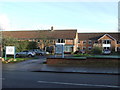
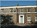
North Court
North Court nursing and residential home Northgate street Bury St.Edmunds Suffolk.
Image: © Keith Evans
Taken: 23 Dec 2007
0.05 miles
3
![Bury St Edmunds buildings [205]](https://s0.geograph.org.uk/geophotos/06/69/31/6693144_237f356d_120x120.jpg)
Bury St Edmunds buildings [205]
This rather unusual building at 109 Northgate Street is known as The Clock House and appears to be as much commercial as residential.
North of the town centre Northgate Street and St John’s Street run towards the site of Northgate and the railway station and both streets have many older buildings. In between these two streets is a number of streets irregularly laid out (compared to the medieval grid of the town centre) containing mostly houses and buildings from the 19th century.
Bury St Edmunds is a market town which is the cultural and retail centre for West Suffolk and is known for brewing (Greene King) and sugar (British Sugar). There is scattered evidence of earlier activity but essentially Bury St Edmunds began as one of the royal boroughs of the Saxons and a monastery was founded which became the burial place of King Edmund. A new Benedictine abbey was built in 1020 which became rich and powerful and the town was laid out on a grid pattern by Abbot Baldwin. After the dissolution the abbey became ruinous. A new church, later the cathedral, was begun in the early 16th century.
Image: © Michael Dibb
Taken: 10 Sep 2020
0.07 miles
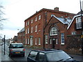
4
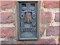
Ordnance Survey Flush Bracket S6734
This can be found on the roadside wall of a building (Falconbury) in Northgate Street, Bury St Edmunds.
For more detail see : http://www.bench-marks.org.uk/bm10750
Image: © Peter Wood
Taken: 14 Nov 2014
0.07 miles
5
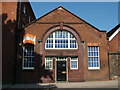
County School, Northgate Street
The school moved long ago. This is a strange mix of grand entrance and factory unit.
Image: © John Goldsmith
Taken: 4 Jun 2010
0.07 miles
6
Interesting clock, strange roof
Judging by the start of the downpipe, there must be some kind of facia in front of the roof.
Also odd is the brickwork of the house front which has lots of strange steps and joins.
Image: © John Goldsmith
Taken: 4 Jun 2010
0.07 miles
7
![Bury St Edmunds buildings [206]](https://s1.geograph.org.uk/geophotos/06/69/31/6693145_3049c49c_120x120.jpg)
Bury St Edmunds buildings [206]
Number 110 Northgate Street, now known as Regent House and used as offices, was built as a house in the early or mid 18th century and subsequently became the main block of the West Suffolk Grammar School and later The West Suffolk College of Further Education. Later extended on both sides with the northern extension now occupied as apartments. See also Image Listed, grade II, with details at: https://historicengland.org.uk/listing/the-list/list-entry/1365771
North of the town centre Northgate Street and St John’s Street run towards the site of Northgate and the railway station and both streets have many older buildings. In between these two streets is a number of streets irregularly laid out (compared to the medieval grid of the town centre) containing mostly houses and buildings from the 19th century.
Bury St Edmunds is a market town which is the cultural and retail centre for West Suffolk and is known for brewing (Greene King) and sugar (British Sugar). There is scattered evidence of earlier activity but essentially Bury St Edmunds began as one of the royal boroughs of the Saxons and a monastery was founded which became the burial place of King Edmund. A new Benedictine abbey was built in 1020 which became rich and powerful and the town was laid out on a grid pattern by Abbot Baldwin. After the dissolution the abbey became ruinous. A new church, later the cathedral, was begun in the early 16th century.
Image: © Michael Dibb
Taken: 10 Sep 2020
0.08 miles
10
Former County School In Northgate Street
The old former county school Northgate street Bury St.Edmunds Suffolk for an old view see http://www.burypastandpresent.org.uk/bg/BRO_K505_2046.jpg old view taken from see http://www.burypastandpresent.org.uk/index.htm
Image: © Keith Evans
Taken: 25 Feb 2007
0.08 miles