IMAGES TAKEN NEAR TO
Lancaster Avenue, BURY ST. EDMUNDS, IP32 6LW
Introduction
This page details the photographs taken nearby to Lancaster Avenue, IP32 6LW by members of the Geograph project.
The Geograph project started in 2005 with the aim of publishing, organising and preserving representative images for every square kilometre of Great Britain, Ireland and the Isle of Man.

There are currently over 7.5m images from over14,400 individuals and you can help contribute to the project by visiting https://www.geograph.org.uk
Image Map
Images are licensed for reuse under creativecommons.org/licenses/by-sa/2.0
Notes
- Clicking on the map will re-center to the selected point.
- The higher the marker number, the further away the image location is from the centre of the postcode.
Image Listing (11 Images Found)
Images are licensed for reuse under creativecommons.org/licenses/by-sa/2.0
Image
Details
Distance
1
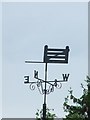
Tollgate
Weather vane in the form of a gate on Tollgate school Bury St.Edmunds Suffolk.
Image: © Keith Evans
Taken: 26 May 2008
0.17 miles
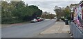
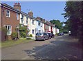
3
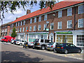
Lake Avenue
Shops on Lake Avenue Bury St.Edmunds, Suffolk.
Image: © Keith Evans
Taken: 19 Feb 2010
0.20 miles
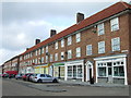
8
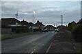
Looking from Tollgate Lane into Philip Road
Image: © Basher Eyre
Taken: 16 Sep 2018
0.24 miles
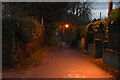
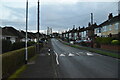
10
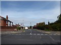
The Klondyke, western section
A gravelled road in three distinct sections: the western part, with a few old cottages; a central area comprising a footpath in a narrow strip of grass; and an eastern section with a few houses and bungalows.
Image: © Carl Grove
Taken: 5 Jul 2013
0.24 miles