IMAGES TAKEN NEAR TO
Sandy Lane, BURY ST. EDMUNDS, IP32 6AJ
Introduction
This page details the photographs taken nearby to Sandy Lane, IP32 6AJ by members of the Geograph project.
The Geograph project started in 2005 with the aim of publishing, organising and preserving representative images for every square kilometre of Great Britain, Ireland and the Isle of Man.

There are currently over 7.5m images from over14,400 individuals and you can help contribute to the project by visiting https://www.geograph.org.uk
Image Map
Images are licensed for reuse under creativecommons.org/licenses/by-sa/2.0
Notes
- Clicking on the map will re-center to the selected point.
- The higher the marker number, the further away the image location is from the centre of the postcode.
Image Listing (66 Images Found)
Images are licensed for reuse under creativecommons.org/licenses/by-sa/2.0
Image
Details
Distance
1
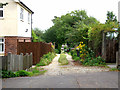
Dirt track joining Northgate Avenue to Fornham Road
Part of the rectangular grid of roads and tracks in this part of town. At the far end you can just see the brake lights of a car waiting to enter Fornham Road.
Image: © John Goldsmith
Taken: 21 Aug 2011
0.03 miles
4
Empty Fornham Road during England match
Looking north towards Fornham, from underneath the A14 road bridge, we see a very empty Fornham Road during an England World Cup football match - this is normally a very busy road. The reverse view appears in Image
There is a surprise lurking just behind the houses on the right - woods and lakes (officially 'ponds') belonging to the sugar factory, and private to them. There is a pedestrian gate just out of shot on the right.
Image: © John Goldsmith
Taken: 18 Jun 2010
0.05 miles
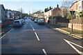
5
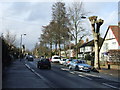
Fornham Road
Fornham Road Bury St.Edmunds, Suffolk.
Image: © Keith Evans
Taken: 21 Feb 2010
0.05 miles
6
Dirt track across Avenue Approach
Part of the rectangular array of roads and dirt tracks in this part of Bury St. Edmunds (See Image), this one runs across Avenue Approach, one of the metalled roads, and continues on the other side. Avenue Approach has unintentionally become one of the significant traffic routes across the town, despite various features inserted to annoy drivers.
Image: © John Goldsmith
Taken: 6 Sep 2009
0.08 miles
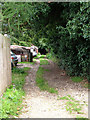
7
Dirt track off Avenue Approach plus classic car
A part of the rectangular grid in this part of Bury St. Edmunds, a further dirt track can be seen making a T junction at the end. This is the reverse view to Image
It's always a bonus to include a classic British car in the shot, such as this Triumph Herald convertible. But who installed such an awkward approach to the garage?
Image: © John Goldsmith
Taken: 21 Aug 2011
0.08 miles
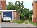
8
Dirt track with a dead end, northern Bury St. Edmunds
The grid pattern of roads and tracks in northern Bury St. Edmunds is generally complete, but this one has a dead end at the back of a row of houses.
Image: © John Goldsmith
Taken: 21 Aug 2011
0.08 miles
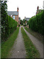
9
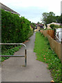
Footpath Fornham Road to Bell Meadow
This northern part of Bury St. Edmunds is divided up into a more or less rectangular grid by paved roads, unpaved roads, and footpaths. This footpath is opposite Avenue Approach so is presumably part of that grid.
Image: © John Goldsmith
Taken: 21 Aug 2011
0.08 miles
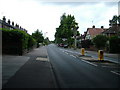
10
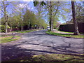
Norfolk Road
Taken from the northern end of Northgate Avenue looking towards Fornham Road
Image: © Carl Grove
Taken: 5 May 2013
0.08 miles