IMAGES TAKEN NEAR TO
Elmswell Road, BURY ST. EDMUNDS, IP31 3HH
Introduction
This page details the photographs taken nearby to Elmswell Road, IP31 3HH by members of the Geograph project.
The Geograph project started in 2005 with the aim of publishing, organising and preserving representative images for every square kilometre of Great Britain, Ireland and the Isle of Man.

There are currently over 7.5m images from over14,400 individuals and you can help contribute to the project by visiting https://www.geograph.org.uk
Image Map
Images are licensed for reuse under creativecommons.org/licenses/by-sa/2.0
Notes
- Clicking on the map will re-center to the selected point.
- The higher the marker number, the further away the image location is from the centre of the postcode.
Image Listing (6 Images Found)
Images are licensed for reuse under creativecommons.org/licenses/by-sa/2.0
Image
Details
Distance
1
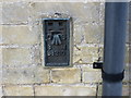
Ordnance Survey Flush Bracket S8210
This can be found on the house wall at Nebbits Farm.
For more detail see : http://www.bench-marks.org.uk/bm12635
Image: © Peter Wood
Taken: 21 Feb 2015
0.11 miles
2
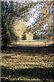
Footpath to Haugh Lane
This path at Great Ashfield leads eastwards from Elmswell Road towards the industrial estate at the former airfield.
Image: © Bob Jones
Taken: 12 Nov 2009
0.12 miles
3
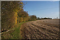
Footpath to Haugh Lane
This path at Great Ashfield follows the northern edge of a large field, leading towards the industrial estate at the former airfield.
Image: © Bob Jones
Taken: 12 Nov 2009
0.15 miles
4
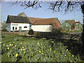
Lea Farm Buildings, Great Ashfield
These are some of the farm buildings at Lea Farm Great Ashfield. They were taken for the Millennium book, Great Ashfield Year 2000
Image: © Geoff Wadsworth
Taken: Unknown
0.20 miles
5
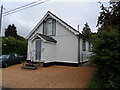
White board building, Great Ashfield
It looks as though it may have been a chapel originally.
Image: © Bikeboy
Taken: 29 May 2014
0.23 miles
6
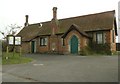
The village hall at Great Ashfield
This Victorian building was originally the village school.
Image: © Robert Edwards
Taken: 17 Mar 2011
0.25 miles