IMAGES TAKEN NEAR TO
Livermere Road, BURY ST. EDMUNDS, IP31 2QD
Introduction
This page details the photographs taken nearby to Livermere Road, IP31 2QD by members of the Geograph project.
The Geograph project started in 2005 with the aim of publishing, organising and preserving representative images for every square kilometre of Great Britain, Ireland and the Isle of Man.

There are currently over 7.5m images from over14,400 individuals and you can help contribute to the project by visiting https://www.geograph.org.uk
Image Map
Images are licensed for reuse under creativecommons.org/licenses/by-sa/2.0
Notes
- Clicking on the map will re-center to the selected point.
- The higher the marker number, the further away the image location is from the centre of the postcode.
Image Listing (6 Images Found)
Images are licensed for reuse under creativecommons.org/licenses/by-sa/2.0
Image
Details
Distance
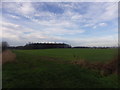
2
Livermere Thicks
Taken from the minor road that passes through the extreme south east corner of the square, this view also takes in a barley field and deserted farm buildings.
Image: © Bob Jones
Taken: 5 Jul 2005
0.09 miles
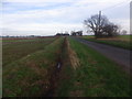
3
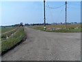
Track to Green Farm
Labelled on the OS map as "Nix Green Farm" but the sign here (between the poles) reads "Green farm"
Image: © Bikeboy
Taken: 10 Apr 2013
0.11 miles
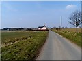
4
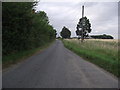
Livermere Road
Looking north along Livermere Road Great Barton, Suffolk.
Image: © Keith Evans
Taken: 7 Jul 2010
0.17 miles