IMAGES TAKEN NEAR TO
Thetford Road, BURY ST. EDMUNDS, IP31 2EY
Introduction
This page details the photographs taken nearby to Thetford Road, IP31 2EY by members of the Geograph project.
The Geograph project started in 2005 with the aim of publishing, organising and preserving representative images for every square kilometre of Great Britain, Ireland and the Isle of Man.

There are currently over 7.5m images from over14,400 individuals and you can help contribute to the project by visiting https://www.geograph.org.uk
Image Map
Images are licensed for reuse under creativecommons.org/licenses/by-sa/2.0
Notes
- Clicking on the map will re-center to the selected point.
- The higher the marker number, the further away the image location is from the centre of the postcode.
Image Listing (215 Images Found)
Images are licensed for reuse under creativecommons.org/licenses/by-sa/2.0
Image
Details
Distance
1
![Ixworth houses [33]](https://s0.geograph.org.uk/geophotos/06/70/80/6708052_456f0a49_120x120.jpg)
Ixworth houses [33]
Number 53 High Street is a 17th century cottage. Timber framed, roughcast front, rendered south gable end, brick and flint north gable end. Listed, grade II, with details at: https://historicengland.org.uk/listing/the-list/list-entry/1031454
Ixworth is a village some 7 miles north east of Bury St Edmunds. Settled in Roman times and the site of a Roman fort. Later a civilian settlement was established and it became an important junction in the Roman road system of East Anglia. An Augustinian priory was founded in about 1170 and dissolved in 1537. Ixworth is the site of the earliest rural council housing built in England. Now most working residents commute to Bury St Edmunds.
Image: © Michael Dibb
Taken: 7 Sep 2020
0.02 miles
2
![Ixworth houses [31]](https://s2.geograph.org.uk/geophotos/06/70/80/6708050_ad015af1_120x120.jpg)
Ixworth houses [31]
Number 51 High Street is early 19th century in painted brick. Listed, grade II, with details at: https://historicengland.org.uk/listing/the-list/list-entry/1031453
Ixworth is a village some 7 miles north east of Bury St Edmunds. Settled in Roman times and the site of a Roman fort. Later a civilian settlement was established and it became an important junction in the Roman road system of East Anglia. An Augustinian priory was founded in about 1170 and dissolved in 1537. Ixworth is the site of the earliest rural council housing built in England. Now most working residents commute to Bury St Edmunds.
Image: © Michael Dibb
Taken: 7 Sep 2020
0.03 miles
3
![Ixworth houses [35]](https://s0.geograph.org.uk/geophotos/06/70/80/6708072_76aff23c_120x120.jpg)
Ixworth houses [35]
Originally a row of three houses, now two. Numbers 55 and 57 High Street were built in the early 19th century, raised and altered in the mid 19th century and converted into two in the mid 20th century. Constructed in dark knapped flint with red brick dressings. The heightening is in gault brick, as are the later dressings. Listed, grade II, with details at: https://historicengland.org.uk/listing/the-list/list-entry/1376829
Ixworth is a village some 7 miles north east of Bury St Edmunds. Settled in Roman times and the site of a Roman fort. Later a civilian settlement was established and it became an important junction in the Roman road system of East Anglia. An Augustinian priory was founded in about 1170 and dissolved in 1537. Ixworth is the site of the earliest rural council housing built in England. Now most working residents commute to Bury St Edmunds.
Image: © Michael Dibb
Taken: 7 Sep 2020
0.03 miles
4
![Ixworth houses [37]](https://s1.geograph.org.uk/geophotos/06/70/81/6708121_c5d06e2f_120x120.jpg)
Ixworth houses [37]
Number 59 High Street is early 19th century, timber framed with roughcast front and stuccoed sides. Listed, grade II, with details at: https://historicengland.org.uk/listing/the-list/list-entry/1031455
Ixworth is a village some 7 miles north east of Bury St Edmunds. Settled in Roman times and the site of a Roman fort. Later a civilian settlement was established and it became an important junction in the Roman road system of East Anglia. An Augustinian priory was founded in about 1170 and dissolved in 1537. Ixworth is the site of the earliest rural council housing built in England. Now most working residents commute to Bury St Edmunds.
Image: © Michael Dibb
Taken: 7 Sep 2020
0.03 miles
5
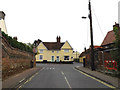
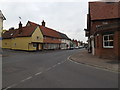
Thetford Road, Ixworth
At the junction with High Street
Image: © Geographer
Taken: 19 Sep 2016
0.03 miles
6
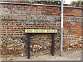
Thetford Road sign
On Thetford Road at the junction with High Street
Image: © Geographer
Taken: 19 Sep 2016
0.03 miles
7
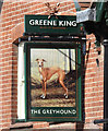
Sign of The Greyhound public house in Ixworth
https://www.geograph.org.uk/photo/6217361
Image: © Adrian S Pye
Taken: 21 Jul 2019
0.03 miles
8
The Greyhound public house, Ixworth
https://www.geograph.org.uk/photo/6217360
Image: © Adrian S Pye
Taken: 21 Jul 2019
0.03 miles
9
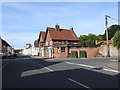
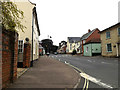
High Street, Ixworth
At the junction with Thetford Road near The Greyhound Public House
Image: © Geographer
Taken: 19 Sep 2016
0.04 miles
10
High Street, Ixworth
At the junction with Thetford Road
Image: © Geographer
Taken: 19 Sep 2016
0.04 miles