IMAGES TAKEN NEAR TO
Cliff Lane, IPSWICH, IP3 0PG
Introduction
This page details the photographs taken nearby to Cliff Lane, IP3 0PG by members of the Geograph project.
The Geograph project started in 2005 with the aim of publishing, organising and preserving representative images for every square kilometre of Great Britain, Ireland and the Isle of Man.

There are currently over 7.5m images from over14,400 individuals and you can help contribute to the project by visiting https://www.geograph.org.uk
Image Map
Images are licensed for reuse under creativecommons.org/licenses/by-sa/2.0
Notes
- Clicking on the map will re-center to the selected point.
- The higher the marker number, the further away the image location is from the centre of the postcode.
Image Listing (41 Images Found)
Images are licensed for reuse under creativecommons.org/licenses/by-sa/2.0
Image
Details
Distance
3
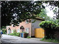
Old building in Holywells park
The park was gifted to the town in 1936, and the old house was demolished in the 60s. This is the only remaining building - it currently houses the ranger station, and looks as though it was once the stable block.
Image: © Oxymoron
Taken: 16 May 2009
0.03 miles
4
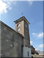
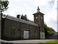
The clock tower of the Stable Block, Holywells Park
The Stable Block is one of the few parts remaining of the old Holywells House. The house was built in 1814 by the Cobbold Family, who had purchased what was then the Pitts Farm estate in 1811, to use the park's spring water for their nearby brewery business. The house was demolished in 1962. The Stable Block is now a visitor centre.
Image: © Chris Holifield
Taken: 2 Apr 2017
0.04 miles
5
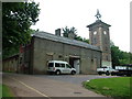
Stable block, Holywells Park
So glad it is not an unstable block.
Image: © John Goldsmith
Taken: 9 Jun 2009
0.04 miles
6
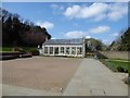
The Conservatory, Holywells Park
Once part of Holywells House, the Conservatory (also known as The Orangery) was refurbished in 2015: http://www.ipswichbuildingpreservationtrust.org.uk/news-2/holywells-orangery-and-stables/. The house itself was demolished in 1962.
Image: © Chris Holifield
Taken: 2 Apr 2017
0.05 miles
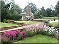
7

Orangery, Holywells Park
Late 19th century building; grade II listed. The knot garden on the left is suffering badly from heat and drought.
Image: © Keith Edkins
Taken: 8 Aug 2018
0.05 miles
8
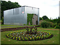
Mystery metal shed, Holywells Park
What old object is hidden under this shiny protective shed, so incongruous in the formal gardens? It has been there some time, as revealed by the creeper and the Google aerial image. It must be more than a garden shed.
Image: © John Goldsmith
Taken: 9 Jun 2009
0.06 miles
10
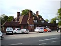
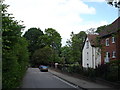
Margaret Catchpole
Public House on Cliff Lane, Ipswich.
http://www.suffolkcamra.co.uk/pubs/pub/516
Image: © Tim Marchant
Taken: 12 May 2009
0.07 miles