IMAGES TAKEN NEAR TO
The Meadows, BURY ST. EDMUNDS, IP30 9TS

Introduction

This page details the photographs taken nearby to The Meadows, IP30 9TS by members of the Geograph project.

The Geograph project started in 2005 with the aim of publishing, organising and preserving representative images for every square kilometre of Great Britain, Ireland and the Isle of Man.

There are currently over 7.5m images from over14,400 individuals and you can help contribute to the project by visiting https://www.geograph.org.uk

Image Map


Images are licensed for reuse under creativecommons.org/licenses/by-sa/2.0
Notes
  • Clicking on the map will re-center to the selected point.
  • The higher the marker number, the further away the image location is from the centre of the postcode.

Image Listing (11 Images Found)

Images are licensed for reuse under creativecommons.org/licenses/by-sa/2.0
Image
Details
Distance
1
Rattlesden Road, Drinkstone Green
Image: © Helen Steed Taken: 30 Jul 2012
0.02 miles
2
Drinkstone Green: Entrance to Drinkstone House
Image: © Michael Garlick Taken: 11 Jul 2020
0.08 miles
3
Drinkstone Green: Park Road looking towards junction with Gedding Road
Image: © Michael Garlick Taken: 11 Jul 2020
0.09 miles
4
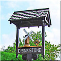
Drinkstone village sign
Drinkstone mill is well known in Suffolk and it is no surprise that it features on the village sign. In fact there are two mills, a post mill and a smock mill, both within 100 yards of each other. The post mill is the oldest postmill in Suffolk having been built 1689 and is Grade I listed. The Smock Mill was built in 1780 on a horse mill which had been in existence in 1689. The mills were known collectively as Clover's Mills as they were worked by the Clover family. Beside the mill is what appears to be a family’s arms, which is a replica of a floor tile in the church. The tile is possibly the coat of arms of Matthew Lovaine who had the advowson of the parish church until his death in 1320 or one of his successors as the tile is dated to the C14th and there are known to have been significant improvements in the church during the 14th century.  https://www.geograph.org.uk/photo/6760249
Image: © Adrian S Pye Taken: 25 Aug 2008
0.14 miles
5
Drinkstone, village sign
This sign was erected for the Queen's silver jubilee in 1977 (ERII, 1977 on post).
Image: © Bikeboy Taken: 29 May 2014
0.15 miles
6
Drinkstone village sign
Drinkstone mill is well known in Suffolk and it is no surprise that it features on the village sign. In fact there are two mills, a post mill and a smock mill, both within 100 yards of each other. The post mill is the oldest postmill in Suffolk having been built 1689 and is Grade I listed. The Smock Mill was built in 1780 on a horse mill which had been in existence in 1689. The mills were known collectively as Clover's Mills as they were worked by the Clover family. Beside the mill is what appears to be a family’s arms, which is a replica of a floor tile in the church. The tile is possibly the coat of arms of Matthew Lovaine who had the advowson of the parish church until his death in 1320 or one of his successors as the tile is dated to the C14th and there are known to have been significant improvements in the church during the 14th century.  https://www.geograph.org.uk/photo/4291804
Image: © Adrian S Pye Taken: 22 Feb 2021
0.15 miles
7
Drinkstone's village sign
Image: © Robert Edwards Taken: 24 Feb 2011
0.16 miles
8
Cross Street, Drinkstone Green
Image: © Helen Steed Taken: 30 Jul 2012
0.16 miles
9
A very overgrown footpath near Drinkstone Green
Image: © Helen Steed Taken: 30 Jul 2012
0.18 miles
10
Further along Rattlesden Road, Drinkstone Green
Image: © Helen Steed Taken: 30 Jul 2012
0.20 miles