IMAGES TAKEN NEAR TO
Rougham Industrial Estate, BURY ST. EDMUNDS, IP30 9ND
Introduction
This page details the photographs taken nearby to Rougham Industrial Estate, IP30 9ND by members of the Geograph project.
The Geograph project started in 2005 with the aim of publishing, organising and preserving representative images for every square kilometre of Great Britain, Ireland and the Isle of Man.

There are currently over 7.5m images from over14,400 individuals and you can help contribute to the project by visiting https://www.geograph.org.uk
Image Map
Images are licensed for reuse under creativecommons.org/licenses/by-sa/2.0
Notes
- Clicking on the map will re-center to the selected point.
- The higher the marker number, the further away the image location is from the centre of the postcode.
Image Listing (8 Images Found)
Images are licensed for reuse under creativecommons.org/licenses/by-sa/2.0
Image
Details
Distance
1
World War 2 buildings, Rougham Airfield
Viewed from General Castle Way, several 1940s buildings survive well into the next century. The airfield now provides an interesting mix of agriculture, industry and recreational facilities.
Image: © John Goldsmith
Taken: 4 May 2009
0.09 miles
2
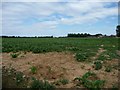
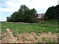
Sugar beet field, Rougham
East of the Rougham Control Tower Museum.
Image: © Christine Johnstone
Taken: 9 Aug 2015
0.15 miles
3
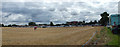
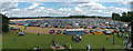
Car parking area for airshow, plus industrial buildings
Very early in the day but the car park is already filling. Behind the cars we can see the industrial operations based on the second world war airfield sites.
This is a two picture panorama.
Image: © John Goldsmith
Taken: 14 Aug 2011
0.17 miles
4
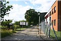
Rougham Industrial Estate
The industrial estate is situated on the former Rougham Airfield, home in World War II of the US Airforce 94th Bomb Group. The road in the photo leads to the old control tower.
Image: © Bob Jones
Taken: 20 Jul 2005
0.18 miles
5
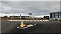
New Roundabout, New Road
Road network developments to the east of Bury St Edmunds.
Image: © Stuart Shepherd
Taken: 23 Sep 2018
0.18 miles
6
Car parking area, Rougham airshow
A harvested cereal field forms the car park for an airshow on the Rougham Airfield. This is a 2 shot panorama. Dozens of aircraft can be seen parked along the runway on the left (north). To the centre-right a row of industrial buildings can be seen, built along the perimeter track. Behind the tall hedge on the right there are further industrial premises, some based on former wartime buildings.
The photographs were taken from the top of the old control tower.
Image: © John Goldsmith
Taken: 14 Aug 2011
0.19 miles
7
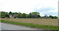
Boundary between industry and agriculture, Rougham
Part of the WW2 RAF Bury St Edmunds is now Rougham Industrial Estate. Part is farmland.
Image: © Christine Johnstone
Taken: 9 Aug 2015
0.20 miles
8
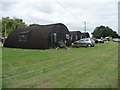
Three Nissen huts, Rougham Control Tower Museum
Two of the huts have been relocated from the former WW2 airfield at Shepherds Grove.
Image: © Christine Johnstone
Taken: 9 Aug 2015
0.24 miles