IMAGES TAKEN NEAR TO
Wintergreen Road, BURY ST. EDMUNDS, IP28 8WP

Introduction

This page details the photographs taken nearby to Wintergreen Road, IP28 8WP by members of the Geograph project.

The Geograph project started in 2005 with the aim of publishing, organising and preserving representative images for every square kilometre of Great Britain, Ireland and the Isle of Man.

There are currently over 7.5m images from over14,400 individuals and you can help contribute to the project by visiting https://www.geograph.org.uk

Image Map


Images are licensed for reuse under creativecommons.org/licenses/by-sa/2.0
Notes
  • Clicking on the map will re-center to the selected point.
  • The higher the marker number, the further away the image location is from the centre of the postcode.

Image Listing (12 Images Found)

Images are licensed for reuse under creativecommons.org/licenses/by-sa/2.0
Image
Details
Distance
1
New housing development, Red Lodge
Image: © N Chadwick Taken: 1 Jul 2011
0.07 miles
2
New housing at Red Lodge
One of several developments around the village. 2,3 and 4 bedroom houses built by Taylor Wimpey and rather abstractly called 'Concept'.
Image: © Hugh Venables Taken: 17 Jan 2010
0.08 miles
3
Wheels Manor, Red Lodge
Presumably owned by a transport magnate (the house name and the digger on the gatepost gives the game away). Note all the barbed wire along the fence and walls.
Image: © Bob Jones Taken: 1 Nov 2006
0.15 miles
4
Red Lodge Garage
This garage has long been disused, judging by the dilapidated state of the tiled cottage next door. It was probably abandoned when the A11 by-passed the village of Red Lodge, back in 1992.
Image: © Bob Jones Taken: 20 Apr 2009
0.15 miles
5
A11 near Red Lodge
Image: © N Chadwick Taken: 3 Jul 2013
0.17 miles
6
A11 near Red Lodge
Image: © N Chadwick Taken: 28 Jun 2012
0.18 miles
7
Eastbound exit slip road from A11 at Red Lodge
Image: © David Smith Taken: 16 Sep 2018
0.21 miles
8
New housing at Red Lodge
The village is expanding rapidly. The A11 gives a good transport link to Cambridge, Newmarket and Norwich. Not sure why they need to block the walking route along Turnpike Road.
Image: © Hugh Venables Taken: 13 Dec 2009
0.23 miles
9
Turnpike Road, Red Lodge
There is something vaguely American about Red Lodge with its dead straight dusty road, scattered modern buildings and roadside diners. The effect is heightened by the presence in the area of many actual Americans who work at nearby RAF Lakenheath and live 'off base'. This was formerly the A11 but is now designated the B1085 since the village was by-passed.
Image: © Stephen McKay Taken: 30 Mar 2019
0.24 miles
10
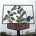
Red Lodge village sign
Red Lodge became a civil parish in 1987, having previously been part of Freckenham parish. The sign is a celebration of the natural history featuring flora and fauna of Red Lodge Heath, which is an area of acid grassland and lowland and is an SSSI, with a number of nationally rare plants and animals. https://www.geograph.org.uk/photo/6767587
Image: © Adrian S Pye Taken: 2 Mar 2021
0.24 miles