IMAGES TAKEN NEAR TO
Sedge Fen, BRANDON, IP27 9LH
Introduction
This page details the photographs taken nearby to IP27 9LH by members of the Geograph project.
The Geograph project started in 2005 with the aim of publishing, organising and preserving representative images for every square kilometre of Great Britain, Ireland and the Isle of Man.

There are currently over 7.5m images from over14,400 individuals and you can help contribute to the project by visiting https://www.geograph.org.uk
Image Map
Images are licensed for reuse under creativecommons.org/licenses/by-sa/2.0
Notes
- Clicking on the map will re-center to the selected point.
- The higher the marker number, the further away the image location is from the centre of the postcode.
Image Listing (4 Images Found)
Images are licensed for reuse under creativecommons.org/licenses/by-sa/2.0
Image
Details
Distance
1
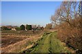
Old Decoy Farm
The bridleway along the bank of the River Little Ouse passes the farm on its way to Brandon Bank.
Image: © Bob Jones
Taken: 21 Nov 2007
0.12 miles
2
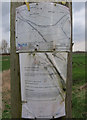
New Bridleway details
When rights of way were formalised they were done county by county. Different counties had different levels of enthusiasm, with several paths stopping at the Suffolk border. This path had a gap in it as it dipped into Suffolk but this has now been filled.
Image: © Hugh Venables
Taken: 10 Mar 2012
0.16 miles
3
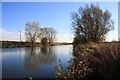
Little Ouse River at Decoy Fen
This navigable river is quite wide at this point, opposite Old Decoy Farm.
Image: © Bob Jones
Taken: 21 Nov 2007
0.19 miles
4
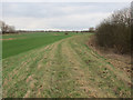
Norfolk Suffolk border
The bridleway stopped here until it re-entered Norfolk but this gap has now been patched, see Image
Image: © Hugh Venables
Taken: 10 Mar 2012
0.21 miles