IMAGES TAKEN NEAR TO
Inghams Lane, THETFORD, IP26 5LF
Introduction
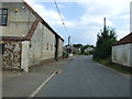
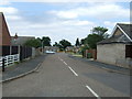
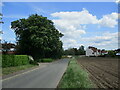
This page details the photographs taken nearby to Inghams Lane, IP26 5LF by members of the Geograph project.
The Geograph project started in 2005 with the aim of publishing, organising and preserving representative images for every square kilometre of Great Britain, Ireland and the Isle of Man.

There are currently over 7.5m images from over14,400 individuals and you can help contribute to the project by visiting https://www.geograph.org.uk
Image Map
Images are licensed for reuse under creativecommons.org/licenses/by-sa/2.0
Notes
- Clicking on the map will re-center to the selected point.
- The higher the marker number, the further away the image location is from the centre of the postcode.
Image Listing (8 Images Found)
Images are licensed for reuse under creativecommons.org/licenses/by-sa/2.0
Image
Details
Distance
1
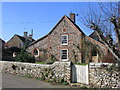
Cottage in Northwold
"WM 1641" carved above top window
Image: © Graham Hardy
Taken: 18 Feb 2006
0.02 miles
2
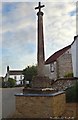
Old Central Cross by West End, Northwold Parish
Northwold Cross, old shaft, base and steps in a new cross by the wayside, in parish of Northwold (Kings Lynn and West Norfolk District), West End.
Grade II* listed. List Entry Number: 1306081
https://historicengland.org.uk/listing/the-list/list-entry/1306081
To be surveyed
Milestone Society National ID: NOKL_NOR
Image: © Milestone Society
Taken: Unknown
0.05 miles
7
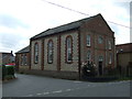
Northwold Tile Centre
In The Old Chapel on High Street.
Image: © JThomas
Taken: 16 Jul 2015
0.20 miles