IMAGES TAKEN NEAR TO
Walnut Drive, THETFORD, IP26 5BG
Introduction
This page details the photographs taken nearby to Walnut Drive, IP26 5BG by members of the Geograph project.
The Geograph project started in 2005 with the aim of publishing, organising and preserving representative images for every square kilometre of Great Britain, Ireland and the Isle of Man.

There are currently over 7.5m images from over14,400 individuals and you can help contribute to the project by visiting https://www.geograph.org.uk
Image Map
Images are licensed for reuse under creativecommons.org/licenses/by-sa/2.0
Notes
- Clicking on the map will re-center to the selected point.
- The higher the marker number, the further away the image location is from the centre of the postcode.
Image Listing (74 Images Found)
Images are licensed for reuse under creativecommons.org/licenses/by-sa/2.0
Image
Details
Distance
1
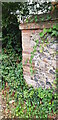
Wall End with Benchmark, Hilborough
There is a cut benchmark in the brickwork at the end of the wall, north side of Swaffham Road. It is shown on the 1905 OS map at 85.3 feet above mean sea level.
Image: © Paul Collins
Taken: 26 Sep 2021
0.03 miles
2
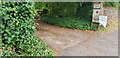
Entrance to The Nunnery, Hilborough
The Nunnery was formerly The Rectory. The left hand gate pillar, covered in ivy, houses an Ordnance Survey Flush Bracket, S160, just visible. See Image
Image: © Paul Collins
Taken: 26 Sep 2021
0.04 miles
3
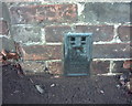
OS Flush Bracket S 0160
Hilborough, The Nunnery.
www.bench-marks.org.uk/bm12062
Image: © Richard Neale
Taken: 1 Nov 2001
0.04 miles
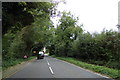
5
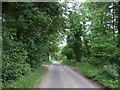
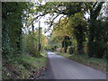
Minor road approaching the A1065, Hilborough
Looking south east.
Image: © JThomas
Taken: 17 Jun 2017
0.08 miles
6
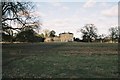
Hilborough Hall
Taken from All Saints Church where lord Horatio Nelson's grandfather, father, uncle, brother and brother-in-law were all rector in succession. The old rectory stood just to the left of the photograph but was demolished during the incumbency of William Nelson who built the Nunnery. The most famous, if least significant, resident of the hall (1858-63) was Richard Wellesley, 2nd Duke of Wellington who, before his fathers death, was the Tory MP for the City of Norwich.
Image: © Chae Cruickshank
Taken: 3 Mar 2006
0.08 miles
8
Field seen from the churchyard at All Saints Church, Hilborough, Norfolk
Image: © John Salmon
Taken: 17 Jun 2008
0.14 miles
9
Gate infield from churchyard All Saints Church, Hilborough, Norfolk
Image: © John Salmon
Taken: 17 Jun 2008
0.15 miles
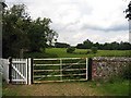
10
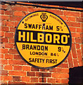
Old circular AA Sign on the A1065 in Hilborough
Old AA Sign on a brick house, once the PO, on west side of the A1065 in Hilborough, 5 miles south of Swaffham. Hilborough parish.
This is the circular, village name on black band, no Motor Union symbol or name type, dating from 1923, and showing distances Swaffham 5¾ Brandon 9¼ London 84¾. Not visible on Google Earth.
There were five series of AA signs, mostly dating from 1923 and made by Francis & Co / Franco in Deptford, London. The village name and distance to London were displayed.
Milestone Society National ID: NO-HILB
Image: © Milestone Society
Taken: Unknown
0.15 miles