
IMAGES TAKEN NEAR TO
Brandon Road, THETFORD, IP26 4RH
Introduction
This page details the photographs taken nearby to Brandon Road, IP26 4RH by members of the Geograph project.
The Geograph project started in 2005 with the aim of publishing, organising and preserving representative images for every square kilometre of Great Britain, Ireland and the Isle of Man.

There are currently over 7.5m images from over14,400 individuals and you can help contribute to the project by visiting https://www.geograph.org.uk
Image Map
Images are licensed for reuse under creativecommons.org/licenses/by-sa/2.0
Notes
- Clicking on the map will re-center to the selected point.
- The higher the marker number, the further away the image location is from the centre of the postcode.
Image Listing (13 Images Found)
Images are licensed for reuse under creativecommons.org/licenses/by-sa/2.0
Image
Details
Distance
1
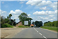
B1112 Brandon Road, Methwold
The main road misses the village centre, which is off to the left.
Image: © Robin Webster
Taken: 12 Jul 2020
0.01 miles
2
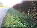
Old Milestone
Old milestone on the B1112 at Methwold, Norfolk. For close up view see http://www.geograph.org.uk/photo/1601848 For more info see http://milestones.megalithia.com/sites/tl738945.htm do look at their home page.
Image: © Keith Evans
Taken: 1 Dec 2009
0.04 miles
3

Old Milestone by the B1112, Brandon Road, Methwold
Carved stone post by the B1112, in parish of METHWOLD (KINGS LYNN AND WEST NORFOLK District), Brandon Road, Methwold, on the verge, on East side of road. Erected by the Stoke Ferry turnpike trust in the 19th century.
Inscription once read:-
: (Brandon / 6 / Miles) : : (Stoke / 4 / Miles ) :
Norfolk HER.
NHER Number: 56736 https://www.heritagegateway.org.uk/Gateway/Results_Single.aspx?uid=MNF63147&resourceID=1002
Milestone Society National ID: NO_SFB4
Image: © M Hallett
Taken: 25 Jan 2004
0.06 miles
4
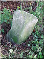
Stoke 4 Brandon 6
Old milestone on the B1112 at Methwold, Norfolk. For overall view see http://www.geograph.org.uk/photo/1601862 For more info see http://milestones.megalithia.com/sites/tl738945.htm do look at their home page.
Image: © Keith Evans
Taken: 1 Dec 2009
0.07 miles
5
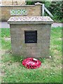
Memorial to R.A.F Methwold
A very plain memorial to R.A.F. Methwold Norfolk.
Image: © Keith Evans
Taken: 29 May 2008
0.11 miles
6
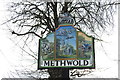
Methwold village sign featuring a Lockheed Ventura ?
RAF Methwold was a bomber base in WW2 and was home to a number of different aircraft: Vickers Wellington, Lockheed Ventura, Short Stirling, Avro Lancaster, Airspeed Horsa and the North American Harvard.
The airfield closed as an operational airfield in 1946 but was kept in care and maintenance until 1960 when it was eventually sold.
Two of the hangars are still in use, although one has been reclad.
The other, in its original state can be seen here
Image: © Adrian S Pye
Taken: 26 Feb 2020
0.11 miles
7
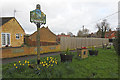
Methwold village sign and RAF Methwold memorial
The village sign features a rather poor representation of a Lockheed Ventura over St George's church, flanked by farming through the ages.
A detail of the sign can be seen here https://www.geograph.org.uk/photo/6399662
Click the https://www.geograph.org.uk/photo/6399666 for a closer view of the memorial
Image: © Adrian S Pye
Taken: 26 Feb 2020
0.11 miles
8
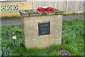
RAF Methwold; in memory of all who served there 1939-1958
RAF Methwold opened as a dispersal airfield for RAF Feltwell in the Winter of 1938. Vickers Wellington bombers from Feltwell continued to use the site as a satellite base until the grass airfield was transferred to No. 2 Group in the exchange of bases with No. 3 Group, in the summer of 1942. Several asphalt hardstandings were put down for aircraft during 1940-1941. In August 1943 the airfield was closed to flying while it was upgraded to A standard. Three concrete runways were built, the main aligned on 06-24 (2,000 yards), 11-29 (1,600 yards) and 17-35 (1,500 yards). 36 hardstandings were built, 35 of the loop type and a single pan. The original asphalt pans were not retained. Following this work, RAF Methwold was a higher standard base than its parent at Feltwell. The airfield was returned to No. 3 Group and became a sub-station of RAF Mildenhall. After closure as an operational airfield in April 1946, the airfield remained under care and maintenance until it was finally sold in the 1960s. Today the majority of the site has been returned to agriculture, with two hangars remaining in use as agricultural grain stores and two others used for packaging Quorn and Cauldron products (Marlow Foods) for sale in supermarkets. To the southern edge of the site a well-preserved battle headquarters and some gunpits along with a number of air raid shelters may be found. (Wikipedia)
Image: © Adrian S Pye
Taken: 26 Feb 2020
0.11 miles
9
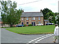
Cottages, Globe Street, Methwold, Norfolk
Image: © Paul Loveday
Taken: 4 Jun 2005
0.13 miles
10
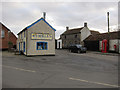
Rumbles Fish Bar, Methwold
Fast food outlet at the junction between High Street and Millgate Street.
Image: © Hugh Venables
Taken: 7 Jan 2012
0.17 miles