IMAGES TAKEN NEAR TO
Hockwold, THETFORD, IP26 4NF
Introduction
This page details the photographs taken nearby to IP26 4NF by members of the Geograph project.
The Geograph project started in 2005 with the aim of publishing, organising and preserving representative images for every square kilometre of Great Britain, Ireland and the Isle of Man.

There are currently over 7.5m images from over14,400 individuals and you can help contribute to the project by visiting https://www.geograph.org.uk
Image Map
Images are licensed for reuse under creativecommons.org/licenses/by-sa/2.0
Notes
- Clicking on the map will re-center to the selected point.
- The higher the marker number, the further away the image location is from the centre of the postcode.
Image Listing (9 Images Found)
Images are licensed for reuse under creativecommons.org/licenses/by-sa/2.0
Image
Details
Distance
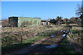
1
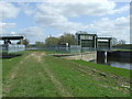
Sluices
Sluices on the Little Ouse River near to Hockwold Cum Wilton, Norfolk.
Image: © Keith Evans
Taken: 19 Apr 2016
0.15 miles
2
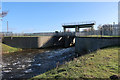
Sluice from Little Ouse River
Water dropping down from the Little Ouse River to a link to the Cut-off Channel.
Image: © Hugh Venables
Taken: 1 Mar 2020
0.16 miles
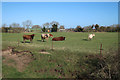
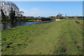
5
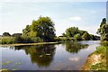
River Little Ouse
At Hockwold cum Wilton. The Norfolk/Suffolk borders runs along the river, with Suffolk on the far side in this view.
Image: © Bob Jones
Taken: 10 Aug 2007
0.20 miles
8
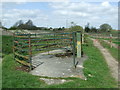
Large Kissing Gate
Very large kissing gate near to Hockwold Cum Wilton, Norfolk.
Image: © Keith Evans
Taken: 19 Apr 2016
0.24 miles
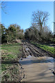
9
Bridleway by Little Ouse River
Looking towards the aqueduct over the Cut-off Channel.
Image: © Hugh Venables
Taken: 1 Mar 2020
0.25 miles