1
The Red Lion in Wilton cum Hockwold, Norfolk
The Red Lion public house is in the centre of the village of Wilton just a stone's throw away from the church of St James. > http://www.geograph.org.uk/photo/2000006
Image: © Adrian S Pye
Taken: 5 Aug 2010
0.14 miles
2
Houses on Main Street, Hockwold cum Wilton
Image: © JThomas
Taken: 19 Aug 2017
0.15 miles
3
Hockwold Store and Post Office
On Main Street.
Image: © JThomas
Taken: 19 Aug 2017
0.16 miles
4
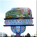
Hockwold cum Wilton village sign
Hockwold cum Wilton's sign is located at the bowls green. It depicts the two churches, on the left, the church of Wilton St James and its rare 14th century spire. On the right is the now redundant church of St Peter, Hockwold. The stream depicts the Little Ouse, which is the southern boundary of the parishes and the county. In the foreground are a hare, two dogs and their handler, recalling the activities of the widely known Hockwold Coursing Club (1920-1939). Below the name, are three devices. Three bee skeps relate to the 17 mentioned in the Domesday Book. The wool sacks recall the days of the 15th and 16th century wool industry. Finally, the chequerboard pattern symbolises the blue and gold arms of Earl William de Warenne who held much land in the area after Domesday.
The previous sign also bore six loaves of bread and acorns. The loaves represented an early charity when six loaves were provided weekly for six poor Protestants, and the acorns represented the 'pannage for 200 hogs and 30 goats'. https://www.geograph.org.uk/photo/6793533
Image: © Adrian S Pye
Taken: 29 Mar 2021
0.16 miles
5
Hockwold village sign
Hockwold cum Wilton's sign is located at the bowls green. It depicts the two churches, on the left, the church of Wilton St James and its rare 14th century spire. On the right is the now redundant church of St Peter, Hockwold. The stream depicts the Little Ouse, which is the southern boundary of the parishes and the county. In the foreground are a hare, two dogs and their handler, recalling the activities of the widely known Hockwold Coursing Club (1920-1939). Below the name, are three devices. Three bee skeps relate to the 17 mentioned in the Domesday Book. The wool sacks recall the days of the 15th and 16th century wool industry. Finally, the chequerboard pattern symbolises the blue and gold arms of Earl William de Warenne who held much land in the area after Domesday.
The previous sign also bore six loaves of bread and acorns. The loaves represented an early charity when six loaves were provided weekly for six poor Protestants, and the acorns represented the 'pannage for 200 hogs and 30 goats'. https://www.geograph.org.uk/photo/6793536
Image: © Adrian S Pye
Taken: 29 Mar 2021
0.16 miles
6
Hockwold Village Hall
Image: © JThomas
Taken: 19 Aug 2017
0.17 miles
7
Hockwold Methodist Church 1875
Image: © Adrian S Pye
Taken: 5 Aug 2010
0.20 miles
8
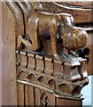
St James Church, Hockwold cum Wilton, Norfolk - Bench elbow
Image: © John Salmon
Taken: 18 Jul 2008
0.22 miles
9
St James Church, Hockwold cum Wilton, Norfolk - Window
Image: © John Salmon
Taken: 18 Jul 2008
0.22 miles
10
The church of St James in Wilton
After the consolidation of the parishes of the adjoining villages of Hockwold and Wilton, and St Peter's church > http://www.geograph.org.uk/photo/1998399 in Hockwold became redundant, St James' now serves as the parish church. The church was built in the 13th and 14th centuries with a spire that is constructed entirely of limestone. The church was extensively restored in the 19th century but retains a (restored) rood screen with interesting carvings > http://www.geograph.org.uk/photo/1999980 and a full set of C15 benches with pierced and traceried backs and carved figures > http://www.geograph.org.uk/photo/1999955 on their ends. Fragments of medieval stained glass > http://www.geograph.org.uk/photo/1999991 can be seen in one of the chancel south windows.
Image: © Evelyn Simak
Taken: 5 Aug 2010
0.22 miles


