IMAGES TAKEN NEAR TO
Corkway Drove, THETFORD, IP26 4JR
Introduction
This page details the photographs taken nearby to Corkway Drove, IP26 4JR by members of the Geograph project.
The Geograph project started in 2005 with the aim of publishing, organising and preserving representative images for every square kilometre of Great Britain, Ireland and the Isle of Man.

There are currently over 7.5m images from over14,400 individuals and you can help contribute to the project by visiting https://www.geograph.org.uk
Image Map
Images are licensed for reuse under creativecommons.org/licenses/by-sa/2.0
Notes
- Clicking on the map will re-center to the selected point.
- The higher the marker number, the further away the image location is from the centre of the postcode.
Image Listing (4 Images Found)
Images are licensed for reuse under creativecommons.org/licenses/by-sa/2.0
Image
Details
Distance
1
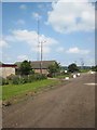
Middle Farm, Feltwell Anchor
The single-storey buildings house the offices of the huge Q Lawns operation, growing turf. It is not certain what the telecommunications mast is for.
Image: © Oliver Dixon
Taken: 8 Jun 2007
0.10 miles
3
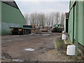
Middle Farm
The wide slick tyres are for working on the turf fields.
Image: © Hugh Venables
Taken: 10 Mar 2012
0.16 miles
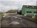
4
New buildings at Middle Farm
The farm produces a mix of vegetables and turf.
Image: © Hugh Venables
Taken: 10 Mar 2012
0.22 miles