IMAGES TAKEN NEAR TO
Southery Road, THETFORD, IP26 4EJ
Introduction
This page details the photographs taken nearby to Southery Road, IP26 4EJ by members of the Geograph project.
The Geograph project started in 2005 with the aim of publishing, organising and preserving representative images for every square kilometre of Great Britain, Ireland and the Isle of Man.

There are currently over 7.5m images from over14,400 individuals and you can help contribute to the project by visiting https://www.geograph.org.uk
Image Map
Images are licensed for reuse under creativecommons.org/licenses/by-sa/2.0
Notes
- Clicking on the map will re-center to the selected point.
- The higher the marker number, the further away the image location is from the centre of the postcode.
Image Listing (4 Images Found)
Images are licensed for reuse under creativecommons.org/licenses/by-sa/2.0
Image
Details
Distance
1
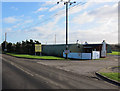
Whitebridge Farm
Offering a range of services, including motor repairs, fishing lake and hot and cold food.
Image: © Hugh Venables
Taken: 7 Jan 2012
0.02 miles
2
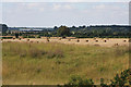
Farmland west of Feltwell
Viewed from the eastern bank of the Cut-off Channel, with farm buildings in the distance at Whitebridge Farm. The grassy bank in the foreground is the western bank of the drainage channel.
Image: © Bob Jones
Taken: 11 Aug 2009
0.18 miles
3
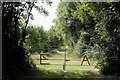
Environment Agency gateway
This gate and track lead southwards from the minor road between Feltwell and Southery, providing access to the western side of the Cut-off Channel.
Image: © Bob Jones
Taken: 11 Aug 2009
0.22 miles
4
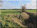
RAF Outfall Drain
One of many ditches in Feltwell Common.
Image: © Hugh Venables
Taken: 7 Jan 2012
0.22 miles