IMAGES TAKEN NEAR TO
St. Marys Street, THETFORD, IP26 4DA
Introduction
This page details the photographs taken nearby to St. Marys Street, IP26 4DA by members of the Geograph project.
The Geograph project started in 2005 with the aim of publishing, organising and preserving representative images for every square kilometre of Great Britain, Ireland and the Isle of Man.

There are currently over 7.5m images from over14,400 individuals and you can help contribute to the project by visiting https://www.geograph.org.uk
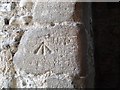
Image Map
Images are licensed for reuse under creativecommons.org/licenses/by-sa/2.0
Notes
- Clicking on the map will re-center to the selected point.
- The higher the marker number, the further away the image location is from the centre of the postcode.
Image Listing (178 Images Found)
Images are licensed for reuse under creativecommons.org/licenses/by-sa/2.0
Image
Details
Distance
1
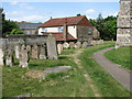
St Mary's church in Feltwell - churchyard
For a view of the church see > http://www.geograph.org.uk/photo/1880999.
Image: © Evelyn Simak
Taken: 25 May 2010
0.01 miles
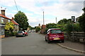
2
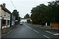
Looking from Bell Street into St Mary's Street
Image: © Basher Eyre
Taken: 26 Sep 2021
0.02 miles
4
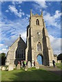
The Church of St Mary at Feltwell
Viewed from the west.
Image: © Peter Wood
Taken: 11 Oct 2014
0.02 miles
5

Ordnance Survey Flush Bracket 10784
This can be found on the wall of St Mary's Church at Feltwell.
For more detail see : http://www.bench-marks.org.uk/bm11824
Image: © Peter Wood
Taken: 11 Oct 2014
0.02 miles
6
Mark on the window of Feltwell St Mary's church
Thought originally to be a pivot bench mark it situated on the reveal of the south window of the clock room (third stage of the tower) at Feltwell St Mary's church in Norfolk. The mark faces east.
For a view of the window in full, click > http://www.geograph.org.uk/photo/1997772
Many suggestions have been made as to its purpose and no conclusions were reached but it could be a Mason's mark, unless somebody can come up with a better suggestion.
Thanks to all who contributed to the discussion.
Image: © Adrian S Pye
Taken: 5 Aug 2010
0.02 miles
7
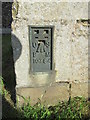
Ordnance Survey Flush Bracket (10784)
This OS Flush Bracket can be found on the west face of St Mary's Church. It marks a point 7.9199m above mean sea level.
Image: © Adrian Dust
Taken: 11 Oct 2014
0.02 miles
8
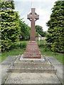
Memorial to the fallen at Feltwell
The Memorial is to those that fell in both 1914-18 and the 1939-1945 Wars. It is situated just south-west of St Mary's church in Feltwell, Norfolk.
Image: © Adrian S Pye
Taken: 5 Aug 2010
0.02 miles
9
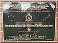
Memorial to 75 (New Zealand) Squadron RAF
This is a close up of the memorial featured here > http://www.geograph.org.uk/photo/1997810
Image: © Adrian S Pye
Taken: 5 Aug 2010
0.02 miles
10
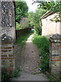
Path from the churchyard
This path leads from St Mary's > http://www.geograph.org.uk/photo/1880999 churchyard to The Beck, a short distance further to the north, emerging near the Post Office > http://www.geograph.org.uk/photo/1880992.
Image: © Evelyn Simak
Taken: 25 May 2010
0.03 miles