IMAGES TAKEN NEAR TO
Barkers Drive, THETFORD, IP26 4BN
Introduction
This page details the photographs taken nearby to Barkers Drive, IP26 4BN by members of the Geograph project.
The Geograph project started in 2005 with the aim of publishing, organising and preserving representative images for every square kilometre of Great Britain, Ireland and the Isle of Man.

There are currently over 7.5m images from over14,400 individuals and you can help contribute to the project by visiting https://www.geograph.org.uk
Image Map
Images are licensed for reuse under creativecommons.org/licenses/by-sa/2.0
Notes
- Clicking on the map will re-center to the selected point.
- The higher the marker number, the further away the image location is from the centre of the postcode.
Image Listing (136 Images Found)
Images are licensed for reuse under creativecommons.org/licenses/by-sa/2.0
Image
Details
Distance
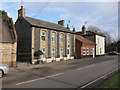
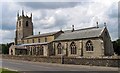
2
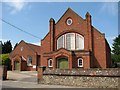
Methodist church in Beck Street, Feltwell
Image: © Evelyn Simak
Taken: 25 May 2010
0.04 miles
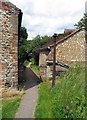
3
Bell Street, Feltwell
Empty building just east of the Church.
Image: © Hugh Venables
Taken: 7 Jan 2012
0.04 miles
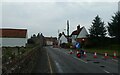
4
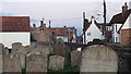
East along Bell Street from St Mary's churchyard, Feltwell
Image: © Chris Brown
Taken: 5 Nov 2017
0.05 miles
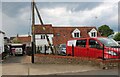
10
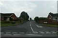
Looking from Bell Street into Newcombe Drive
Image: © Basher Eyre
Taken: 26 Sep 2021
0.08 miles