IMAGES TAKEN NEAR TO
The Street, HARLESTON, IP20 9NP
Introduction
This page details the photographs taken nearby to The Street, IP20 9NP by members of the Geograph project.
The Geograph project started in 2005 with the aim of publishing, organising and preserving representative images for every square kilometre of Great Britain, Ireland and the Isle of Man.

There are currently over 7.5m images from over14,400 individuals and you can help contribute to the project by visiting https://www.geograph.org.uk
Image Map
Images are licensed for reuse under creativecommons.org/licenses/by-sa/2.0
Notes
- Clicking on the map will re-center to the selected point.
- The higher the marker number, the further away the image location is from the centre of the postcode.
Image Listing (110 Images Found)
Images are licensed for reuse under creativecommons.org/licenses/by-sa/2.0
Image
Details
Distance
1
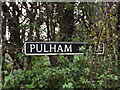
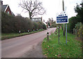
Pulham Road sign
On Pulham Road entering Sparton near Sparston Village Name sign
Road No.C.8777
Image: © Geographer
Taken: 22 Nov 2014
0.05 miles
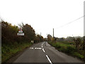
2
Sparston Village Name sign on Pulham Road
Road No.C877
Image: © Geographer
Taken: 22 Nov 2014
0.05 miles
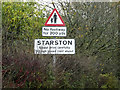
3
Entering Sparston on Pulham Road
Road No.C877
Image: © Geographer
Taken: 22 Nov 2014
0.05 miles
4
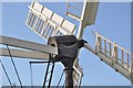
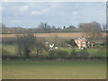
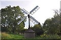
Starston Windpump
A view of the small spring sails (without shutters) and the cog mechanisms in the 'cap'.
This windpump, located in the corner of a field south of The Street, is a Grade 2 Scheduled Ancient Monument and believed to be the only one of its type left. It was erected in 1832 and has been restored with help from English Heritage and Norfolk County Council.
It pumped water from the nearby beck to massive tanks at a nearby home and also a local farm.
Image: © Ashley Dace
Taken: 9 Sep 2010
0.06 miles
5
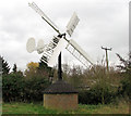
Traditional wind turbine
On the edge of Starston, it even has a turbine.
Image: © Ashley Dace
Taken: 29 Mar 2009
0.07 miles
6
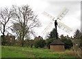
Hollow post windpump in Starston
This windpump, located in the corner of a field south of The Street, is a Grade 2 Scheduled Ancient Monument and believed to be the only one of its type left. It was erected in 1832 and has been restored with help from English Heritage and Norfolk County Council. The windpump has since been adopted as a symbol for the village of Starston > http://www.geograph.org.uk/photo/1592935.
Image: © Evelyn Simak
Taken: 23 Nov 2009
0.07 miles
7
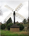
Hollow post windpump in Starston
This windpump, located in the corner of a field south of The Street, is a Grade 2 Scheduled Ancient Monument and believed to be the only one of its type left. It was erected in 1832 and has been restored with help from English Heritage and Norfolk County Council. The windpump has since been adopted as a symbol for the village of Starston > http://www.geograph.org.uk/photo/1592935.
Image: © Evelyn Simak
Taken: 23 Nov 2009
0.07 miles
8
Hollow post windpump in Starston
This windpump, located in the corner of a field south of The Street, is a Grade 2 Scheduled Ancient Monument and believed to be the only one of its type left. It was erected in 1832 and has been restored with help from English Heritage and Norfolk County Council. The windpump has since been adopted as a symbol for the village of Starston > http://www.geograph.org.uk/photo/1592935.
Image: © Evelyn Simak
Taken: 23 Nov 2009
0.07 miles
9
Starston Hollow Windpump
This windpump, located in the corner of a field south of The Street, is a Grade 2 Scheduled Ancient Monument and believed to be the only one of its type left. It was erected in 1832 and has been restored with help from English Heritage and Norfolk County Council.
It pumped water from the nearby beck to massive tanks at a nearby home and also a local farm.
Image: © Ashley Dace
Taken: 9 Sep 2010
0.07 miles
10
Starston village sign on The Street
The village sign is located a short distance north of the hollow post windpump > http://www.geograph.org.uk/photo/1592950 it has adpoted.
The village of Starston covers an area of 9.02 square kilometres and has a population of approximately 320. Between 1856 and 1866 it had its own railway station on the Waveney Valley Line before it was shut to passenger trains through lack of usage. Starston station > http://www.geograph.org.uk/photo/1592857 was one of the first station to close in 1866 but freight and passenger through trains continued until the 1960s. The station has since been converted into a private dwelling house. The parish church, St Margaret's > http://www.geograph.org.uk/photo/1593311 is located on an elevation overlooking the Beck and the main street, called The Street. Starston is without pub (closed in the 1950s) and no longer has a village shop (closed in the early 1980s) and the village school was closed in 1968.
Image: © Evelyn Simak
Taken: 23 Nov 2009
0.08 miles