IMAGES TAKEN NEAR TO
Denton Low Road, HARLESTON, IP20 0AT
Introduction
This page details the photographs taken nearby to Denton Low Road, IP20 0AT by members of the Geograph project.
The Geograph project started in 2005 with the aim of publishing, organising and preserving representative images for every square kilometre of Great Britain, Ireland and the Isle of Man.

There are currently over 7.5m images from over14,400 individuals and you can help contribute to the project by visiting https://www.geograph.org.uk
Image Map
Images are licensed for reuse under creativecommons.org/licenses/by-sa/2.0
Notes
- Clicking on the map will re-center to the selected point.
- The higher the marker number, the further away the image location is from the centre of the postcode.
Image Listing (68 Images Found)
Images are licensed for reuse under creativecommons.org/licenses/by-sa/2.0
Image
Details
Distance
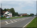
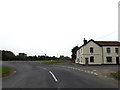
1
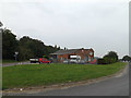
Station Road Motors
Off Denton Low Road at the junction with Station Road
Image: © Geographer
Taken: 11 Sep 2014
0.00 miles
2
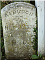
Old Milestone by Station Road Motors, Low Road, Alburgh parish
Carved stone post by the UC road, in parish of ALBURGH (SOUTH NORFOLK District), re-located to near entrance to Station Road Motors, by gate post in garden, on South side of road. GY-S wedge, erected by an unknown authority in the 19th century.
Original Grid Ref approx: TM 2840 8629
Inscription reads:-
: ALBURGH / {-} / TO / BUNGAY / 4 / MILES : : ALBURGH / {-} / TO / HARLESTON / 3 / MILES :
Carved benchmark on top.
Milestone Society National ID: NO_HBu3.
Image: © CW Haines
Taken: 14 Oct 2006
0.01 miles
3
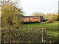
Homersfield goods shed from the former track
Homersfield goods shed had an adjoining grain store attached in 1898 and the building is still in use today as a vehicle repair facility.
Image: © Adrian S Pye
Taken: 24 Nov 2022
0.01 miles
4
The site of the former goods yard at Homersfield
The goods yard has two sidings to a cattle pen and a turntable (centre - right of the picture near the tree) with three short spur sidings with a connection to a large goods shed and adjoining grain store added in 1898. The building remains extant and in use as a vehicle repair facility.
Image: © Adrian S Pye
Taken: 24 Nov 2022
0.01 miles
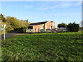
5
Site of Homersfield railway station
This is the site of the small station at Homersfield. It was on the Waveney Valley railway which ran from Beccles to Tivetshall. The line closed in the 1950s and the trackbed used for the road in the 1970s. This road used the trackbed from Ditchingham to Harleston.
The garage is the old goods shed , the station being approx where the junction is.
http://pre-grouping.fotopic.net/p13009707.html
Image: © Ashley Dace
Taken: 6 Aug 2009
0.01 miles
6
Former Homersfield goods shed and station site
On the former Waveney valley railway running from Beccles to Tivetshall. Homersfield station served a largely agricultural area, although its importance in WW2 was increased with a large 1 mile siding nearby. It was used for bomb transportation to nearby airfields like Flixton.
The station was demolished when most of the route from Dichingham to Harleston was turned into a road, the goods shed survives as a reminder that at this quaint rural branch, famous engines like the surviving J15 at the North Norfolk railway used to regularly work. The goods shed is now a garage.
Image: © Ashley Dace
Taken: 7 Mar 2007
0.02 miles
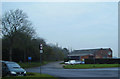
7
Denton Low Road, Alburgh
At the junction with Station Road
Image: © Geographer
Taken: 11 Sep 2014
0.03 miles
8
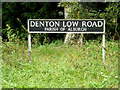
Denton Low Road sign
On Denton Low Road at the junction with Station Road
Image: © Geographer
Taken: 11 Sep 2014
0.03 miles
9
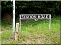
Station Road sign
On Station Road at the junction with Denton Low Road
Image: © Geographer
Taken: 11 Sep 2014
0.03 miles
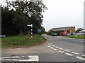
10
Denton Low Road, Alburgh
At the junction with Station Road approaching the A143 Bungay Road
Image: © Geographer
Taken: 11 Sep 2014
0.03 miles