IMAGES TAKEN NEAR TO
Mells, HALESWORTH, IP19 9DD
Introduction
This page details the photographs taken nearby to IP19 9DD by members of the Geograph project.
The Geograph project started in 2005 with the aim of publishing, organising and preserving representative images for every square kilometre of Great Britain, Ireland and the Isle of Man.

There are currently over 7.5m images from over14,400 individuals and you can help contribute to the project by visiting https://www.geograph.org.uk
Image Map
Images are licensed for reuse under creativecommons.org/licenses/by-sa/2.0
Notes
- Clicking on the map will re-center to the selected point.
- The higher the marker number, the further away the image location is from the centre of the postcode.
Image Listing (38 Images Found)
Images are licensed for reuse under creativecommons.org/licenses/by-sa/2.0
Image
Details
Distance
1
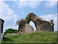
Mells St Margaret's chapel
The chapel was abandoned centuries ago but once served the hamlet of Mells.
More information is available in my book, ‘A photographic and Historical Guide to the Parish Churches of East Suffolk’.
Image: © Adrian S Pye
Taken: 22 May 2007
0.03 miles
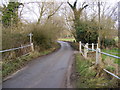
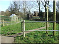
2
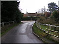
Bridge Lane, Mells
Near the Water Gauging Station
Road No.U2620
Image: © Geographer
Taken: 29 Jan 2009
0.05 miles
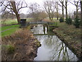

5
Mells gauging station on the River Blyth
Taken from the road bridge, the river is shallow at the moment and the water murky with the banks overgrown and neglected
Image: © Adrian S Pye
Taken: 4 Feb 2023
0.06 miles
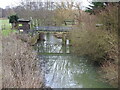
6
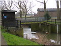
River Blyth Gauging Station
Near St.Margaret's Farm
Image: © Geographer
Taken: 29 Jan 2009
0.06 miles
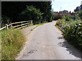
7
Holton Road at Mells Village
Looking towards the B1123 Southwold Road near the footpaths to Blyford Bridge & New Reach & also the Water Gauging Station
Road No.C201
Image: © Geographer
Taken: 29 Jan 2009
0.06 miles
8
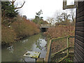
Road bridge over the River Blyth
Taken from the gauging station. The river is overgrown and neglected, despite being publicised as a popular, enjoyable walk. Fallen trees and mud-banks spoil the river and the path is muddy and made narrow by overgrown hedges on some stretches.
Image: © Adrian S Pye
Taken: 4 Feb 2023
0.06 miles
10
Footpath
Footpath looking east that runs next to the River Blyth near to Mells, Suffolk.
Image: © Keith Evans
Taken: 12 Mar 2015
0.07 miles