IMAGES TAKEN NEAR TO
Mill Road, HALESWORTH, IP19 0NT
Introduction
This page details the photographs taken nearby to Mill Road, IP19 0NT by members of the Geograph project.
The Geograph project started in 2005 with the aim of publishing, organising and preserving representative images for every square kilometre of Great Britain, Ireland and the Isle of Man.

There are currently over 7.5m images from over14,400 individuals and you can help contribute to the project by visiting https://www.geograph.org.uk
Image Map
Images are licensed for reuse under creativecommons.org/licenses/by-sa/2.0
Notes
- Clicking on the map will re-center to the selected point.
- The higher the marker number, the further away the image location is from the centre of the postcode.
Image Listing (35 Images Found)
Images are licensed for reuse under creativecommons.org/licenses/by-sa/2.0
Image
Details
Distance
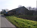
1
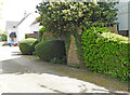
The wall is partially obscured by hedges
To be found in a small development called The Forge, not surprisingly where the Rumburgh Blacksmith, Robert Green, once used to ply his trade.
Image: © Adrian S Pye
Taken: 4 May 2023
0.02 miles
2
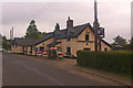
The Rumburgh Buck
A 16th century freehouse. For closeup of sign painted on wall see Image
Image: © Ian Capper
Taken: 3 Aug 2008
0.02 miles
3
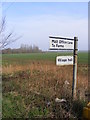
Roadsign on Mill Road
At the junction with Malt Office Lane
Image: © Geographer
Taken: 17 Feb 2011
0.02 miles
4

The Rumburgh Buck
See Image Closeup of sign painted on wall.
Image: © Ian Capper
Taken: 3 Aug 2008
0.02 miles
5
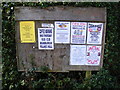
Rumburgh & St.James Village Notice Board
On the corner of Malt Office Lane
Image: © Geographer
Taken: 17 Feb 2011
0.03 miles
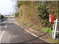
6
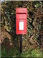
Malt Office Lane Postbox
On Malt Office Lane at the junction with Mill Road
Postbox No.IP19 5525
Image: © Geographer
Taken: 17 Feb 2011
0.03 miles
7
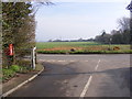
Malt Office Lane & Malt Office Lane Postbox
On Malt Office Lane at the junction with Mill Road
Postbox No.IP19 5525
Image: © Geographer
Taken: 17 Feb 2011
0.03 miles
8
Malt Office Lane & Malt Office Lane Postbox
On Malt Office Lane at the junction with Mill Road
Postbox No.IP19 5525
Image: © Geographer
Taken: 17 Feb 2011
0.03 miles
9
Rumburgh and St. Michael's Village Hall
Dating from 1937 and constructed out of a WWI hut, it was built for the use of the residents of Rumburgh, and managed by St Michaels Church, hence the combined title.
Image: © Ian Capper
Taken: 3 Aug 2008
0.03 miles
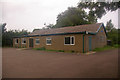
10
Rumburgh & St James Village Hall
On Malt Office Lane at the junction with Mill Road
Image: © Geographer
Taken: 17 Feb 2011
0.03 miles