IMAGES TAKEN NEAR TO
Walberswick, SOUTHWOLD, IP18 6UT
Introduction
This page details the photographs taken nearby to IP18 6UT by members of the Geograph project.
The Geograph project started in 2005 with the aim of publishing, organising and preserving representative images for every square kilometre of Great Britain, Ireland and the Isle of Man.

There are currently over 7.5m images from over14,400 individuals and you can help contribute to the project by visiting https://www.geograph.org.uk
Image Map
Images are licensed for reuse under creativecommons.org/licenses/by-sa/2.0
Notes
- Clicking on the map will re-center to the selected point.
- The higher the marker number, the further away the image location is from the centre of the postcode.
Image Listing (25 Images Found)
Images are licensed for reuse under creativecommons.org/licenses/by-sa/2.0
Image
Details
Distance
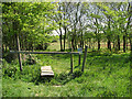
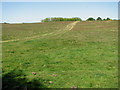
1
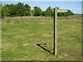
Footpath sign south of Tinker's Barn, Walberswick Common
The house can be glimpsed amongst the trees seen in the background. The Common comprises over 162 acres (65 hectares) of land, mainly heathland, in and around Walberswick. It was once traversed by the Southwold to Halesworth railway line which has since been dismantled, with sections of it serving as footpaths. The Common is managed by the Walberswick Common Lands Charity (founded in 1901) which uses the income from its lands to protect the environment and provide charitable benefit to the inhabitants of Walberswick.
Image: © Evelyn Simak
Taken: 1 May 2011
0.04 miles
2
Approaching Tinker's Barn, Walberswick Common
The house can be glimpsed amongst the trees seen in the background. The Common comprises over 162 acres (65 hectares) of land, mainly heathland, in and around Walberswick. It was once traversed by the Southwold to Halesworth railway line which has since been dismantled, with sections of it serving as footpaths. The Common is managed by the Walberswick Common Lands Charity (founded in 1901) which uses the income from its lands to protect the environment and provide charitable benefit to the inhabitants of Walberswick.
Image: © Evelyn Simak
Taken: 1 May 2011
0.05 miles
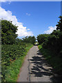
3
Path up past Tinker's Barn
From Tinker's House the path up past Tinker's Barn
Image: © Shaun Ferguson
Taken: 15 Jun 2021
0.05 miles
4
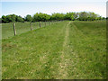
Footpath to Walberswick Common
It leads alongside a stock fence. A stile takes the path across the fence and onto the Common, a short distance further to the east.
Image: © Evelyn Simak
Taken: 1 May 2011
0.06 miles
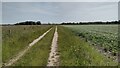
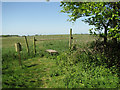
5
Stile on footpath leading onto Walberswick Common
The stile takes the footpath over a stockfence and into the Common.
Image: © Evelyn Simak
Taken: 1 May 2011
0.07 miles
6
Stile on footpath south of Tinker's Barn, Walberswick Common
The stile takes the footpath out of Walberswick Common and onto farmland further to the west.
Image: © Evelyn Simak
Taken: 1 May 2011
0.07 miles
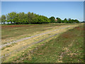
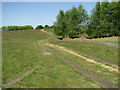
7
Old Railway line - Walberswick Common, Suffolk
The long dismantled Southwold Branch line now provides a footpath across the common
Image: © John Winfield
Taken: 25 Aug 2005
0.08 miles
8
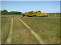
Flowering gorse beside the track to Tinker's Barn, Walberswick Common
The Common comprises over 162 acres (65 hectares) of land, mainly heathland, in and around Walberswick. It was once traversed by the Southwold to Halesworth railway line which has since been dismantled, with sections of it serving as footpaths. The Common is managed by the Walberswick Common Lands Charity (founded in 1901) which uses the income from its lands to protect the environment and provide charitable benefit to the inhabitants of Walberswick.
Gorse is closely related to the brooms and all species have yellow flowers, some with a very long flowering season. The only species native in most of western Europe is Common Gorse (Ulex europaeus). Common Gorse flowers most profusely in spring, but it bears flowers throughout the year and there is an old saying that when gorse is out of blossom, kissing is out of fashion. Other names for gorse are furse, whin and furze.
Image: © Evelyn Simak
Taken: 1 May 2011
0.09 miles
9
Path on Walberswick Common
The Common comprises over 162 acres (65 hectares) of land, mainly heathland, in and around Walberswick. It was once traversed by the Southwold to Halesworth railway line which has since been dismantled, with sections of it serving as footpaths. The Common is managed by the Walberswick Common Lands Charity (founded in 1901) which uses the income from its lands to protect the environment and provide charitable benefit to the inhabitants of Walberswick.
Image: © Evelyn Simak
Taken: 1 May 2011
0.11 miles
10
Path to Tinker's Barn, Walberswick Common
The Common comprises over 162 acres (65 hectares) of land, mainly heathland, in and around Walberswick. It was once traversed by the Southwold to Halesworth railway line which has since been dismantled, with sections of it serving as footpaths. The Common is managed by the Walberswick Common Lands Charity (founded in 1901) which uses the income from its lands to protect the environment and provide charitable benefit to the inhabitants of Walberswick.
Image: © Evelyn Simak
Taken: 1 May 2011
0.11 miles