
IMAGES TAKEN NEAR TO
The Green, SOUTHWOLD, IP18 6TX
Introduction
This page details the photographs taken nearby to The Green, IP18 6TX by members of the Geograph project.
The Geograph project started in 2005 with the aim of publishing, organising and preserving representative images for every square kilometre of Great Britain, Ireland and the Isle of Man.

There are currently over 7.5m images from over14,400 individuals and you can help contribute to the project by visiting https://www.geograph.org.uk
Image Map
Images are licensed for reuse under creativecommons.org/licenses/by-sa/2.0
Notes
- Clicking on the map will re-center to the selected point.
- The higher the marker number, the further away the image location is from the centre of the postcode.
Image Listing (226 Images Found)
Images are licensed for reuse under creativecommons.org/licenses/by-sa/2.0
Image
Details
Distance
1
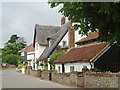
Cottages, Walberswick
Cottages with pantile and thatched roofs behind a flint wall in the village of Walberswick.
Image: © Eileen Henderson
Taken: 19 Jun 2006
0.01 miles
2

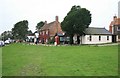
Sign for the Bell Inn, Walberswick
Adnams is brewed across the river in Southwold.
Image: © Maigheach-gheal
Taken: 17 Apr 2008
0.03 miles
4
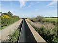
Inner flood protection wall at Walberswick
The wall is between two floodgates, see > http://www.geograph.org.uk/photo/2080578
Image: © Adrian S Pye
Taken: 22 Sep 2010
0.04 miles
6

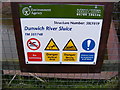
Walberswick village sign
Close-up of the sign by the village green in 2000. You can play spot the differences with later photos, euch as Image (2009).
(It appears that the ship has been away on a cruise.)
The plaques imply this sign was erected to commemorate the Coronation in 1953, and re-erected in August 1987. However, it is actually a reduced-scale replacement for the original sign.
The 1953 sign had been erected on the approach to the village but was stolen in the 1980s. It resurfaced in 2012, when it was renovated and erected near the church.
See Image
Image: © Ian Taylor
Taken: 22 Apr 2000
0.04 miles
7
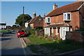
Ferry Road, Walberswick
Taken from the end of The Street.
Image: © Trevor Harris
Taken: 3 Jul 2011
0.04 miles
8
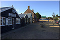
Ferry Road, Walberswick. Looking towards the green.
Image: © Robert Eva
Taken: 28 Jul 2018
0.04 miles
9
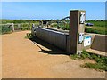
Flood defences at Walberswick
This massive gate on the road to the carpark can be closed to protect the village of Walberswick from flooding by the sea.
Image: © Oliver Dixon
Taken: 6 Jun 2006
0.04 miles
10
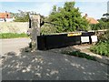
Floodgate at Walberswick, Suffolk
This is just one of the floodgates on the inner flood protection wall. Normally it is in this position, open; but when a surge or spring tide threatens they are closed to protect the village from the floodwaters.
Image: © Adrian S Pye
Taken: 22 Sep 2010
0.05 miles