
IMAGES TAKEN NEAR TO
Easton Lane, SOUTHWOLD, IP18 6SS
Introduction
This page details the photographs taken nearby to Easton Lane, IP18 6SS by members of the Geograph project.
The Geograph project started in 2005 with the aim of publishing, organising and preserving representative images for every square kilometre of Great Britain, Ireland and the Isle of Man.

There are currently over 7.5m images from over14,400 individuals and you can help contribute to the project by visiting https://www.geograph.org.uk
Image Map
Images are licensed for reuse under creativecommons.org/licenses/by-sa/2.0
Notes
- Clicking on the map will re-center to the selected point.
- The higher the marker number, the further away the image location is from the centre of the postcode.
Image Listing (5 Images Found)
Images are licensed for reuse under creativecommons.org/licenses/by-sa/2.0
Image
Details
Distance
1
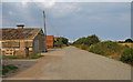
Easton Farm, Easton Bavents, Reydon
The road is marked "private".
Easton Bavents was once a thriving village, at one time extending over a mile east from the current shoreline into the North Sea. Until the C17 most easterly parish in England.
Currently the sea continues to erode the coastline, with agricultural land leading up to the cliff edge.
Image: © Roger Jones
Taken: 7 Jul 2018
0.02 miles
2
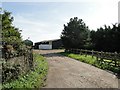
Entrance to Broadside Park Farm
Broadside Park Farm is just to the north-east of Reydon Industrial complex.
Image: © Adrian S Pye
Taken: 21 Sep 2010
0.12 miles
4
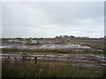
Pigs in muck
Free range pig farming west of Lowestoft Road.
Image: © JThomas
Taken: 11 Oct 2016
0.22 miles
5

Erosion at Easton Cliffs
The house is on Easton Lane.
Image: © Mat Fascione
Taken: 25 Jun 2018
0.25 miles