IMAGES TAKEN NEAR TO
The Street, SAXMUNDHAM, IP17 3NL

Introduction

This page details the photographs taken nearby to The Street, IP17 3NL by members of the Geograph project.

The Geograph project started in 2005 with the aim of publishing, organising and preserving representative images for every square kilometre of Great Britain, Ireland and the Isle of Man.

There are currently over 7.5m images from over14,400 individuals and you can help contribute to the project by visiting https://www.geograph.org.uk

Image Map


Images are licensed for reuse under creativecommons.org/licenses/by-sa/2.0
Notes
  • Clicking on the map will re-center to the selected point.
  • The higher the marker number, the further away the image location is from the centre of the postcode.

Image Listing (99 Images Found)

Images are licensed for reuse under creativecommons.org/licenses/by-sa/2.0
  • ...
Image
Details
Distance
1
Bus shelter and old telephone box on the green, Middleton
Image: © Evelyn Simak Taken: 14 Aug 2011
0.01 miles
2
Middleton: the corner of Rectory Road
The former chapel to the right of the van is dated 1828.
Image: © John Sutton Taken: 22 May 2018
0.01 miles
3
Middleton village green
Image: © Evelyn Simak Taken: 14 Aug 2011
0.01 miles
4
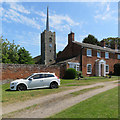
Middleton: towards Holy Trinity
"W tower with tall flushwork-panelled battlements. Recessed lead needle-spire" (Nikolaus Pevsner).
Image: © John Sutton Taken: 22 May 2018
0.02 miles
5
Holy Trinity: the parish church of Middleton
The church dates back to the Norman period and stands at the heart of the very pretty village of Middleton.
Image: © Robert Edwards Taken: 26 Jun 2014
0.02 miles
6
Middleton: Rectory Road
The primary school is on the right.
Image: © John Sutton Taken: 22 May 2018
0.02 miles
7
Middleton: benches outside The Bell Inn
The former chapel on the right is dated 1828.
Image: © John Sutton Taken: 22 May 2018
0.02 miles
8
Pink cottages by the green, Middleton
Image: © Evelyn Simak Taken: 14 Aug 2011
0.02 miles
9
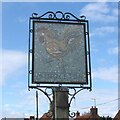
Middleton (Suffolk) village sign - the reverse
A dark mosaic sign depicting a cockerel on a blue background on one side and probably representative of the Weathercock on the church steeple. The other side of the sign shows the church of the Holy Trinity but the detail is indistinguishable. On the post is a bell remindful of The Bell Inn public house just a few yards away. https://www.geograph.org.uk/photo/6633082 I have received an email from a gentleman informing me that "The artist who created this sign was Jessica Costello, my grandmother. She lived at Vine Cottage in Middleton from the early 1970s to the early or mid 80s. The design of the sign references a story about the church weathercock: apparently, it vanished one night and was not found on the ground, hence the depiction of the cockerel stepping forward or walking away." My sincere thanks to him for getting in touch.
Image: © Adrian S Pye Taken: 27 Oct 2007
0.03 miles
10
Middleton (Suffolk) village sign
A dark mosaic sign depicting a cockerel on a blue background on one side and probably representative of the Weathercock on the church steeple. The other side of the sign shows the church of the Holy Trinity but the detail is indistinguishable. On the post is a bell remindful of The Bell Inn public house just a few yards away. https://www.geograph.org.uk/photo/6633083
Image: © Adrian S Pye Taken: 27 Oct 2007
0.03 miles
  • ...