IMAGES TAKEN NEAR TO
Post Office Road, SAXMUNDHAM, IP17 1UG
Introduction
This page details the photographs taken nearby to Post Office Road, IP17 1UG by members of the Geograph project.
The Geograph project started in 2005 with the aim of publishing, organising and preserving representative images for every square kilometre of Great Britain, Ireland and the Isle of Man.

There are currently over 7.5m images from over14,400 individuals and you can help contribute to the project by visiting https://www.geograph.org.uk
Image Map
Images are licensed for reuse under creativecommons.org/licenses/by-sa/2.0
Notes
- Clicking on the map will re-center to the selected point.
- The higher the marker number, the further away the image location is from the centre of the postcode.
Image Listing (76 Images Found)
Images are licensed for reuse under creativecommons.org/licenses/by-sa/2.0
Image
Details
Distance
1
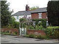
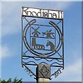
Knodishall Common
The cottages face the village sign by the B1069. On the base of the sign is a plaque that reads: "This sign was erected in the year 2000 by the residents of Knodishall to mark the millennium. Time capsule in base."
Image: © David Squire
Taken: 21 May 2006
0.01 miles
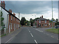
2
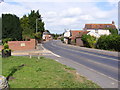
Post Office Road, Knodishall
At the junction with the B1069 Snape Road
Image: © Geographer
Taken: 21 Jul 2011
0.01 miles
4
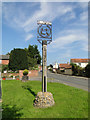
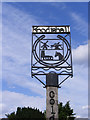
Knodishall village sign
The sign is primarily for the parish of Knoddishall but it hasn’t forgotten the hamlet of Coldfair Green or the parish of Buxlow which no longer has a church and has become very much a part of Knoddishall after 1865. The sign depicts a horseshoe in the centre of which is the windmill, which once stood in the centre of the village in Mill Road. A blacksmith’s anvil, complete with hammer and tongs. The church of St Lawrence which is located in the northwest corner of the parish and a donkey representing Knodishall Whin
Image: © Adrian S Pye
Taken: 15 Sep 2014
0.03 miles
5
Knoddishall and Buxlow village sign
The sign is primarily for the parish of Knoddishall but it hasn’t forgotten the hamlet of Coldfair Green or the parish of Buxlow which no longer has a church and has become very much a part of Knoddishall after 1865. The sign depicts a horseshoe in the centre of which is the windmill, which once stood in the centre of the village in Mill Road. A blacksmith’s anvil, complete with hammer and tongs. The church of St Lawrence which is located in the northwest corner of the parish and a donkey representing Knodishall Whin
The other side includes Coldfair https://www.geograph.org.uk/photo/4166644
Image: © Adrian S Pye
Taken: 4 Feb 2021
0.03 miles
6
Village sign for Knodishall and Coldfair
The sign is primarily for the parish of Knoddishall but it hasn’t forgotten the hamlet of Coldfair Green or the parish of Buxlow which no longer has a church and has become very much a part of Knoddishall after 1865. The sign depicts a horseshoe in the centre of which is the windmill, which once stood in the centre of the village in Mill Road. A blacksmith’s anvil, complete with hammer and tongs. The church of St Lawrence which is located in the northwest corner of the parish and a donkey representing Knodishall Whin.
Image: © Adrian S Pye
Taken: 15 Sep 2014
0.03 miles
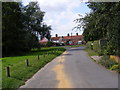
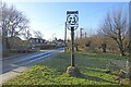
7
Knodishall Village Sign
On the B1069 Leiston Road at Coldfair Green
Image: © Geographer
Taken: 17 Aug 2009
0.03 miles
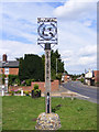
8
Knodishall Village Sign
On the B1069 Leiston Road at Coldfair Green
Coldfair Green
(Close up)
Image: © Geographer
Taken: 17 Aug 2009
0.03 miles
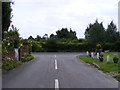
9
B1069 Leiston Road, Coldfair Green
Looking towards Leiston near Knodishall Village Sign
Image: © Geographer
Taken: 17 Aug 2009
0.03 miles