
IMAGES TAKEN NEAR TO
High Street, SAXMUNDHAM, IP17 1DF
Introduction
This page details the photographs taken nearby to High Street, IP17 1DF by members of the Geograph project.
The Geograph project started in 2005 with the aim of publishing, organising and preserving representative images for every square kilometre of Great Britain, Ireland and the Isle of Man.

There are currently over 7.5m images from over14,400 individuals and you can help contribute to the project by visiting https://www.geograph.org.uk
Image Map
Images are licensed for reuse under creativecommons.org/licenses/by-sa/2.0
Notes
- Clicking on the map will re-center to the selected point.
- The higher the marker number, the further away the image location is from the centre of the postcode.
Image Listing (712 Images Found)
Images are licensed for reuse under creativecommons.org/licenses/by-sa/2.0
Image
Details
Distance
1
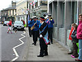
St. George's day celebration, Saxmundham High Street
Unicycling clown meets band outside Barclays. Behind that The Cotton Tree (formerly Martin's), the Bistro (formerly the Martin family home), Flicks (formerly Ashfords), Elisabeth's, etc.
Image: © John Goldsmith
Taken: 17 Apr 2008
0.00 miles
3
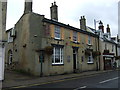
The Queens Head, Saxmundham
On High Street.
Image: © JThomas
Taken: 16 Sep 2015
0.01 miles
4
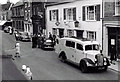
Accident in the High Street , about 1960
An Austin A30 (not an A35, as it has the small rear window) has had a collision and although no damage is visible an ambulance has been called. It is hard to imagine how the accident occurred, as there is dropped oil and/or water on the other side of the street.
At that time the subject was the accident but now the old street scene is the main interest. The road was the main A12, now carried on a bypass. The buildings have hardly changed, though all but the two banks do contain different businesses.
The photo was taken from upstairs at number 17/19.
Image: © Frank Goldsmith
Taken: Unknown
0.01 miles
5
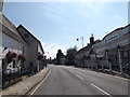
B1121 High Street, Saxmundham
Near the Co-op Pharmacy
Image: © Geographer
Taken: 7 Aug 2015
0.01 miles
7
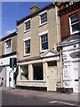
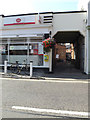
Former Post Office, Saxmundham
On the B1122 High Street
Image: © Geographer
Taken: 26 May 2013
0.01 miles
8
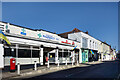
Pharmacy, Post Office and Other Shops
Shops on Saxmundham High Street. The pharmacy and post office building is different from the rest of the terrace, with a touch of deco in its appearance and a ramp up to the door.
Image: © Des Blenkinsopp
Taken: 19 Mar 2022
0.01 miles
9
![Saxmundham buildings [4]](https://s2.geograph.org.uk/geophotos/06/72/79/6727990_dbb53023_120x120.jpg)
Saxmundham buildings [4]
Number 10 High Street, now offices with a maisonette above, was built as a house in the early 19th century with the top floor added circa 1840. Built in red brick with a gault brick front. The shop front is 20th century. Listed, grade II, with details at: https://historicengland.org.uk/listing/the-list/list-entry/1268188
Saxmundham is a small market town about 5 miles from the Sussex coast and some 18 miles north east of Ipswich. The River Fromus, a tributary of the River Alde flows through the town. A market charter was first granted in 1272 and a market is still held every Wednesday. Until 1988 the town was astride the A12 trunk road but is now bypassed.
Image: © Michael Dibb
Taken: 10 Sep 2020
0.01 miles
10

Saxmundham High Street with Christmas lights
Image: © Christopher Hilton
Taken: 2 Jan 2026
0.01 miles