IMAGES TAKEN NEAR TO
Aldringham, LEISTON, IP16 4QP
Introduction
This page details the photographs taken nearby to IP16 4QP by members of the Geograph project.
The Geograph project started in 2005 with the aim of publishing, organising and preserving representative images for every square kilometre of Great Britain, Ireland and the Isle of Man.

There are currently over 7.5m images from over14,400 individuals and you can help contribute to the project by visiting https://www.geograph.org.uk
Image Map
Images are licensed for reuse under creativecommons.org/licenses/by-sa/2.0
Notes
- Clicking on the map will re-center to the selected point.
- The higher the marker number, the further away the image location is from the centre of the postcode.
Image Listing (27 Images Found)
Images are licensed for reuse under creativecommons.org/licenses/by-sa/2.0
Image
Details
Distance
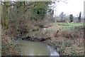
1
Footbridge over Hundred River , Aldringham
Image: © Roger Miller
Taken: 4 Mar 2007
0.07 miles
2
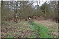
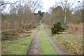
Footpath towards Bird's Farm
Looking north-east from Leiston Road. The path used to cross the heathland of North Warren, but is now largely wooded.
Image: © Simon Mortimer
Taken: 13 Apr 2022
0.08 miles
5
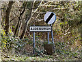
Aldeburgh Town Name sign
On the B1122 Aldeburgh Road
Image: © Geographer
Taken: 3 Feb 2015
0.14 miles
6
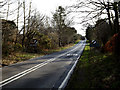
Entering Aldeburgh on the B1122 Aldeburgh Road
Image: © Geographer
Taken: 3 Feb 2015
0.14 miles
7
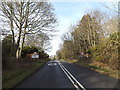
Entering Aldrington on the B1122 Aldeburgh Road
Image: © Geographer
Taken: 3 Feb 2015
0.14 miles
8
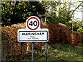
Aldringham Village Name sign
On the B1122 Aldeburgh Road
Image: © Geographer
Taken: 3 Feb 2015
0.14 miles
9
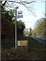
Bus Stop & Birch Tree Lodge sign
On the B1122 Aldeburgh Road
Image: © Geographer
Taken: 3 Feb 2015
0.14 miles
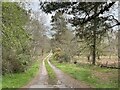
10
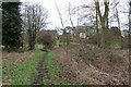
Footpath leading to Bird's Farm, Aldringham
Image: © Roger Miller
Taken: 4 Mar 2007
0.16 miles