IMAGES TAKEN NEAR TO
Ravensfield Road, IPSWICH, IP1 5ED
Introduction
This page details the photographs taken nearby to Ravensfield Road, IP1 5ED by members of the Geograph project.
The Geograph project started in 2005 with the aim of publishing, organising and preserving representative images for every square kilometre of Great Britain, Ireland and the Isle of Man.

There are currently over 7.5m images from over14,400 individuals and you can help contribute to the project by visiting https://www.geograph.org.uk
Image Map
Images are licensed for reuse under creativecommons.org/licenses/by-sa/2.0
Notes
- Clicking on the map will re-center to the selected point.
- The higher the marker number, the further away the image location is from the centre of the postcode.
Image Listing (17 Images Found)
Images are licensed for reuse under creativecommons.org/licenses/by-sa/2.0
Image
Details
Distance
1
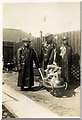
The local Fire Guard Station.
The Photograph was taken in 1940 (World War 2)
Image: © Eric Woodhouse
Taken: Unknown
0.06 miles
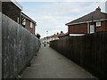
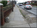
3
Footpath alongside Westbourne Acadaemy
Image: © Jonathan Thacker
Taken: 12 May 2022
0.13 miles
4
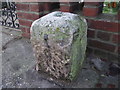
Old Milestone by the A1156, Norwich Road, Ipswich
Stone post (plate lost) by the A1156, in parish of IPSWICH (IPSWICH District), Norwich Road, by the road, on West side of road. Erected by the Claydon, Blakenham, Brockford & Stowmarket turnpike trust in the 19th century.
Inscription once read:-
(Bury St Edmunds)
(24)
(Ipswich)
(2)
Milestone Society National ID: SU_SMIW10.
Image: © R Mudhar
Taken: 7 Nov 2001
0.13 miles
5
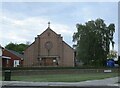
Church of St. Mary Magdalene, Ipswich
Image: © Jonathan Thacker
Taken: 12 May 2022
0.14 miles
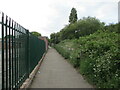
6
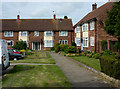
Houses set back from Highfield Road
The northern of two short spurs off Highfield Road.
Image: © Andrew Hill
Taken: 9 May 2009
0.17 miles
7
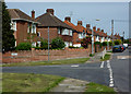
Houses on Highfield Road
Looking beyond the junction with Highfield Road, a short street connecting with the main Norwich Road.
Image: © Andrew Hill
Taken: 9 May 2009
0.18 miles
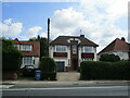
9
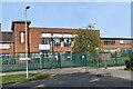
Westbourne Academy, Ipswich
The school dates back to 1939 and the facade seen here reflects the 1930s architecture of the origincal building. The school has been known as Western Senior Girls' School, Westbourne School, Westbourne High School and Westbourne Sports College before becoming an academy in 2013.
Image: © Simon Mortimer
Taken: 12 Sep 2020
0.18 miles
10
Old Milepost
Old milepost Norwich Road Ipswich, Suffolk on what was the old A45 / A140. For close up view see http://www.geograph.org.uk/photo/1168442 for info on the post see http://milestones.megalithia.com/sites/tm144467.htm do look at their home page.
Image: © Keith Evans
Taken: 18 Feb 2009
0.19 miles