IMAGES TAKEN NEAR TO
Parham, WOODBRIDGE, IP13 9NB
Introduction
This page details the photographs taken nearby to IP13 9NB by members of the Geograph project.
The Geograph project started in 2005 with the aim of publishing, organising and preserving representative images for every square kilometre of Great Britain, Ireland and the Isle of Man.

There are currently over 7.5m images from over14,400 individuals and you can help contribute to the project by visiting https://www.geograph.org.uk
Image Map
Images are licensed for reuse under creativecommons.org/licenses/by-sa/2.0
Notes
- Clicking on the map will re-center to the selected point.
- The higher the marker number, the further away the image location is from the centre of the postcode.
Image Listing (40 Images Found)
Images are licensed for reuse under creativecommons.org/licenses/by-sa/2.0
Image
Details
Distance
2
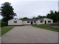
Parham Village Hall
Off the B1116 Main Road
Image: © Geographer
Taken: 11 Jun 2010
0.14 miles
3
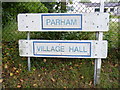
Parham Village Hall sign
Off the B1116 Main Road
Image: © Geographer
Taken: 11 Jun 2010
0.17 miles
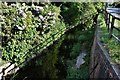
5
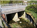
Culvert under The Street, Parham
The River Ore flowing under
Image: © Geographer
Taken: 11 Apr 2011
0.22 miles
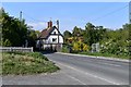
6
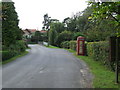
The street Parham
Telephone box The Street Parham Suffolk.
Image: © Keith Evans
Taken: 30 Sep 2007
0.22 miles
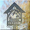
7
Parham village sign (new)
The sign incorporates many aspects of the community including the lychgate of the church and the woodsman standing under it representing Parham Wood an ancient wood of about 23 hectares. A B17, Fortress which flew from the USAAF station during WW2 not only represents the sacrifice made by those who served but also the Museum in the old control tower. The church of St. Mary the Virgin is shown with pears hanging from the tree alluding to the name of the parish.
The old sign was this https://www.geograph.org.uk/photo/4293716
Image: © Adrian S Pye
Taken: 20 Dec 2020
0.23 miles
8
Parham village sign (new)
The sign incorporates many aspects of the community including the lychgate of the church and the woodsman standing under it representing Parham Wood an ancient wood of about 23 hectares. A B17, Fortress which flew from the USAAF station during WW2 not only represents the sacrifice made by those who served but also the Museum in the old control tower. The church of St. Mary the Virgin is shown with pears hanging from the tree alluding to the name of the parish.
The old sign was this https://www.geograph.org.uk/photo/4293716
Image: © Adrian S Pye
Taken: 20 Dec 2020
0.23 miles
9

Framlingham Road Postbox
On the B1116 Main Road
Postbox No.IP13 6305
Image: © Geographer
Taken: 22 Aug 2010
0.23 miles
10

B1116 Framlingham Road & Framlingham Road Postbox
Looking towards Hatcheston
Postbox No.IP13 6305
Image: © Geographer
Taken: 22 Aug 2010
0.23 miles